
Flood zone check for a list of sites
Find out which of your sites sit in a flood zone.
Give Mapstack your list of sites and the flood zone map for your area. You get every site checked against the zones: a list, a map and a table.
Free to start. No card.
| Open schools | Schools |
|---|---|
| Flood zone 3 | 5 |
| Flood zone 2 | 5 |
| Outside both | 64 |
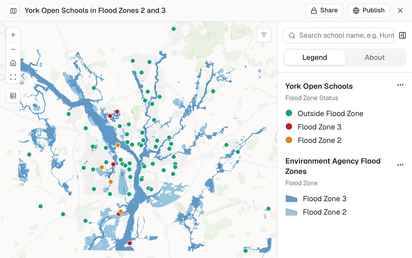
10 of the 74 open schools are in a flood zone.
For whoever gets asked
An insurer asks.A board asks.A planner asks.
Which of your sites are at risk, and how do you know?
The usual answer is to look sites up one at a time on a public flood map, and hope nobody asks about the ones near an edge.
This checks the whole list at once, and hands you the table.
One real check
74 schools, two flood zones, ten flagged
Two public files: the Department for Education's register of schools in York, and the Environment Agency's Flood Map for Planning for the same area.
- The sites
- 74open schools, each at its exact location
- The zones
- 1,467flood zone shapes, zone 2 and zone 3
- The answer
- 10schools inside a flood zone
- Flood zone 3
- 5
- Flood zone 2
- 5
- Outside both
- 64
Every site is in the table, not only the flagged ones: all 74, each with its zone.
Zone 3 is land with the highest chance of flooding from rivers or the sea; zone 2 has a medium chance.
Schools: Department for Education, Get Information About Schools. Flood zones: Environment Agency, Flood Map for Planning (Rivers and Sea), zones 2 and 3. Both downloaded 11 November 2026.
Check the ones near an edge
A site a few metres from the edge of a zone is the one to look at twice. Name it, say what your own check found, and ask.
Treat the first answer the way you would treat a colleague's: check the close calls, say what you found, and have it put right.
Our own check puts Saint Barnabas in flood zone 2, about 30 m outside the nearest zone 3 area, and Clifton With Rawcliffe Primary inside zone 3. Can you check both schools against the flood zone polygons again and correct the table if they're wrong?
Mapstack ran the check again for all 74 open schools, on the exact coordinates from the register, and gave a final table. The map was updated with it.
How it goes
You bring the sites and the zones, and say the rule. Mapstack does the checking.
Attach your sites and the zones.
Mapstack checks every site against the zones and makes the map.
You get the table someone asked for: every site, its postcode, its zone.
The step-by-step guide is in the documentation: Check which of your sites sit in a flood zone.
Flood is one layer
The same check works for any list of sites and any layer of zones. Each of these is something you can ask for today.
Other hazards
Bring the zones as a file, cut to your area.
- Which of our sites are inside a wildfire zone?
- Flag every depot on land at risk of subsidence.
- Which sites are inside a landslide zone?
Other lines on the map
A zone is any area with an edge.
- Which of our properties are inside a conservation area?
- Which of these addresses fall inside our service area?
Then hand it over
The answer is for someone: an insurer, a board, a planner.
- Make it a table I can give to the insurer.
- Is the Clifton site in a flood zone?
- Put it on a map I can share with the board.
Common questions
What happens to my site list?
It stays in your workspace. Only people with a seat in your workspace can see it. Nothing leaves unless you publish it yourself.
It is not used to train AI. Your data and your conversations are not used to train AI models.
It is still yours. You keep ownership of what you bring in. Delete it and it is removed.
The full answer is in the documentation: Your data, privacy and security.
What does it cost?
Free to start. One seat, for you, with a starter amount of work each month. No card.
This job is on the free seat. Maps, datasets, analysis, your own files and public sharing are all included.
Pay per person for more. A paid seat brings more work each month, and seats for your team.
The prices are on the pricing page.
How does the check work?
You bring the zones. The official flood risk map for your area, as a file. In England that is the Environment Agency's Flood Map for Planning (rivers and the sea); in the United States, FEMA's flood maps.
By where it really is. Each site is tested at its own location against the shapes of the zones.
By your rule. Say how to treat a site that touches two zones. "Worst zone wins" is the usual one.
Nothing dropped quietly. A site it could not place is reported, not skipped.
Check yours.
Free to start. No card.