
Mapstack Analysis
AI spatial analysis for GIS work.
Ask the question. Mapstack runs the analysis on your data and shows its working.
Free to start. No card.
Watch a question get answered
One question, start to finish: asked in plain words, worked out on the data, handed back for your review.
Answer more questions. Build fewer workflows.
Your AI teammate does the analysis
From a question to an answer you can check, handed back for your review.
Ask the question, not the tool
Say what you need to know, in plain words or in GIS terms. Mapstack picks the method and runs it, so you skip building the workflow.
An answer, not a layer
You get the figure, the ranking or the shortlist you asked for, not a pile of output layers to dig the answer out of.
Mapstack shows its working
Every answer comes with the method, the settings and the sources, so you can check it before you repeat it to anyone.
One question leads to the next
Narrow it, compare it, try a what-if. Each follow-up builds on the last answer, so you never set the analysis up again.
Keep what it worked out
Every result is saved as a dataset. Map it, share it or take it into your desktop GIS, so the work is never locked in a chat.
Run it again next month
Set an analysis to rerun when new data arrives, so the monthly update stops being your job.
The answer, in the form you need
Mapstack is not a map vending machine. Sometimes the answer is a number, sometimes a table, sometimes a map, sometimes a report for someone else. You get whichever fits the question.
Which sites reach the most households?
Harbour Road reaches the most.
Site Households Harbour Road 61,200 Mill Lane 48,900 Station Square 44,300 A straight answer
A figure, a ranking or a short table, said in the conversation.
Households within 15 minutes24 rows
Site Minutes Households Harbour Road 15 61,200 Mill Lane 15 48,900 Station Square 15 44,300 Quay Street 15 39,700 Northgate 15 36,100 Abbey Park 15 31,800 A dataset
Every result kept as a table you can sort, map or take away.
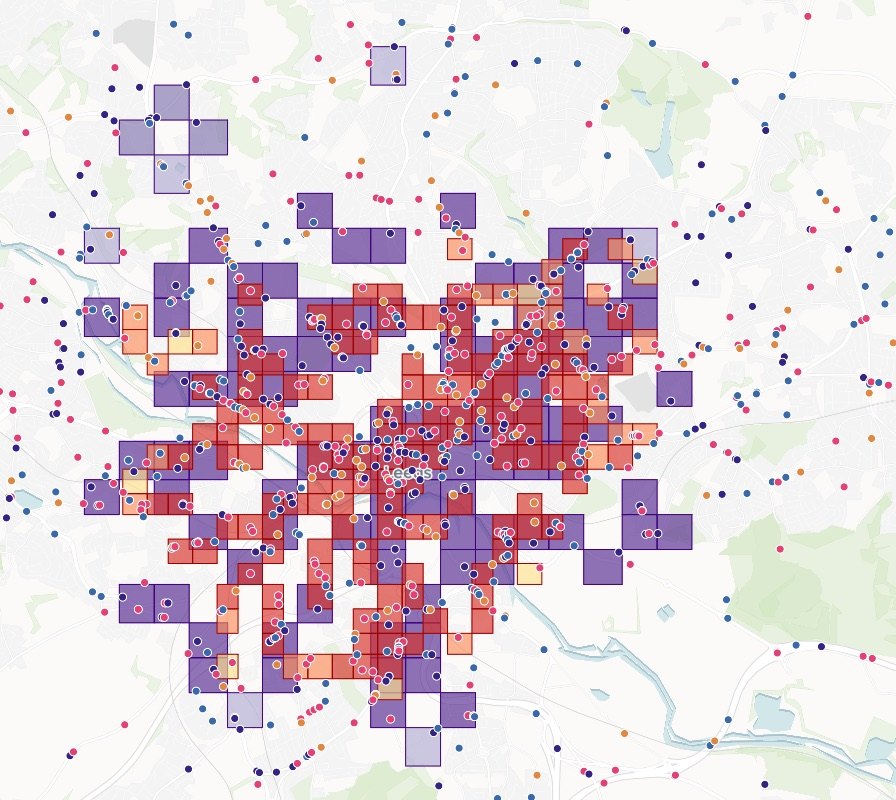
A map
The answer drawn where it applies, ready to share.
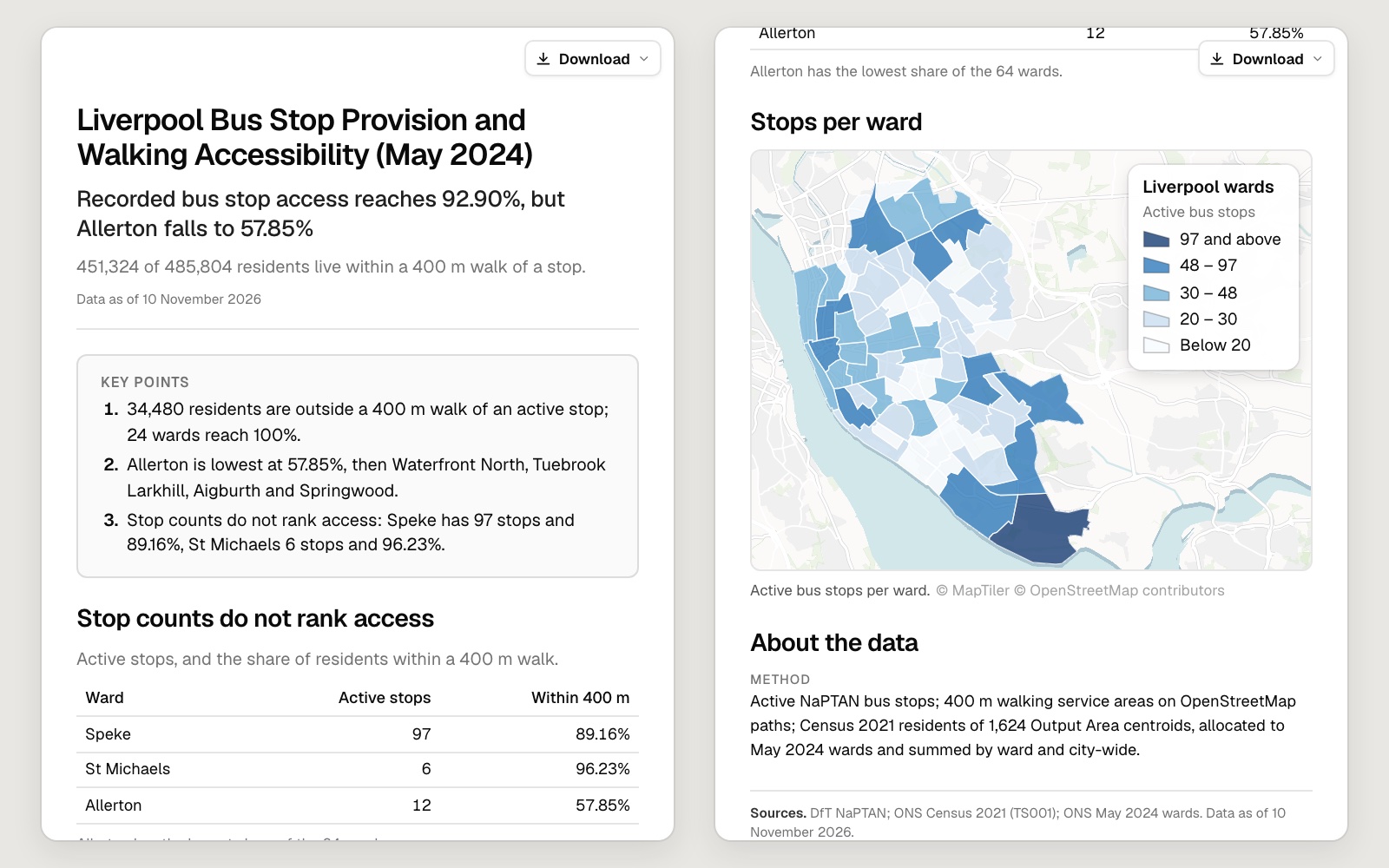
A report
The findings written up with figures and maps, for whoever asked.
Every answer shows its working
No black box. Each result comes back with what was done and what it was done with, so you can check it the way you would check a colleague’s.
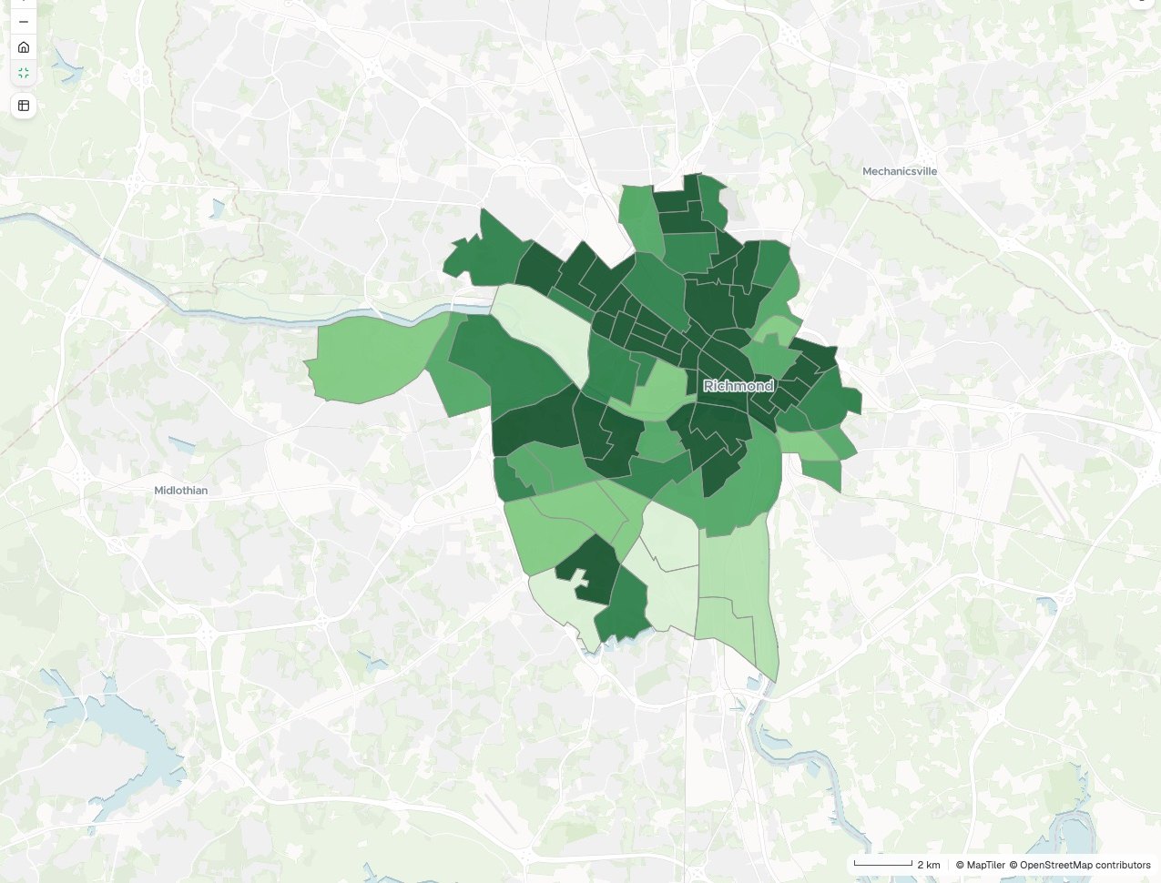
Access score
Shops, transit and parks within a 10-minute walk
- 6 – 7
- 5
- 4
- 3
- 1 – 2
Neighbourhoods by score
- 6 – 79
- 514
- 421
- 312
- 1 – 27
- The answer, on the map. The result drawn where it applies, with a legend that says what was measured.
- The figures behind it. The numbers summarised beside the map, linked to what is on screen.
- Method and sources. What was run, with which settings, on which data. Written out, not hidden.
- Any place, looked up. Search for one area and see its own figure.
- Yours to pass on. Share the answer by link, or take the result out as data.
Ask the questions you never have time for
Four questions, as someone would type them, and what came back.
See who is within reach
Kindred, a modern vet-clinic group choosing its next site
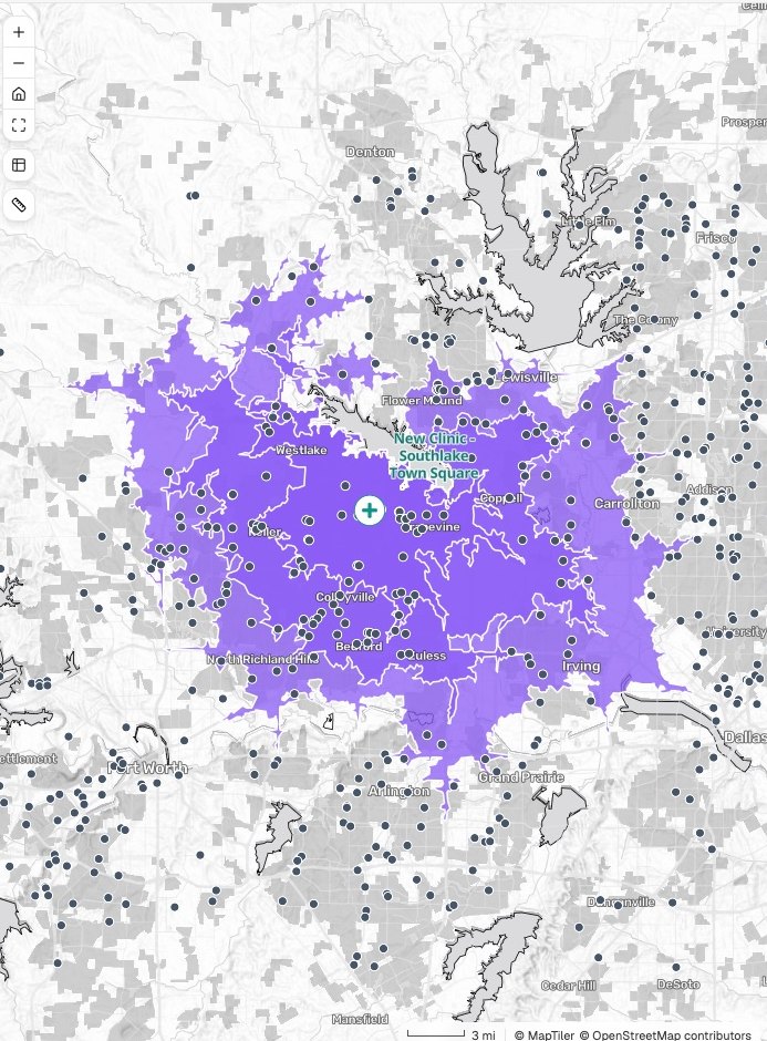
Drive time
Households inside each band
- 10 minutes · 44,600
- 15 minutes · 184,900
- 20 minutes · 423,700
The request
We are looking at a site in the town square for our next clinic. How many households are within a 10, 15 and 20-minute drive, and how many other vet clinics are inside each band?
What came back
- Three drive-time bands, by road
- Households and competitors counted in each
- A summary table to put in front of the board
Share the stops between your vans
Northbean, a coffee roaster delivering to cafés
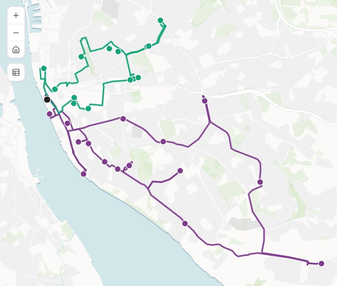
Routes
Stops and driving time
- Van 1 · 22 stops · 4 h 10
- Van 2 · 19 stops · 3 h 35
The request
Attached are Thursday’s 41 café deliveries. Share them between two vans leaving the roastery at 7, in the order that keeps driving time lowest. Each van has to be back by 1.
What came back
- Two routes, each stop in order
- Driving time for each van, inside the working day
- A stop list for each driver
Find where it is more than chance
Dashly, a grocery-delivery app chasing late orders
Hot spots
Confidence that it is not chance
- Evening · 99%
- Evening · 95%
- Late night · 99%
- Late night · 95%
The request
Attached is every late delivery from the last quarter, with a time and a location. Find the hot spots for the evening rush and for late night, and tell me which are statistically significant.
What came back
- Hot spots tested, not just counted
- Evening and late night shown apart
- The confidence of each hot spot in the legend
Find who is left out
Freshlane, an online grocer placing pick-up lockers
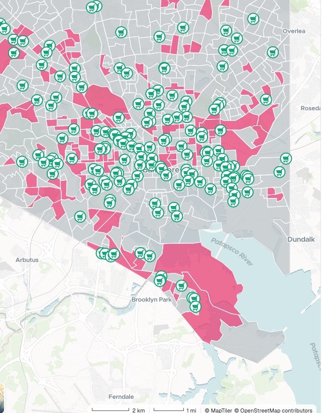
Neighbourhoods
Walking access and car ownership
- Priority · 108 areas
- Other areas
- Supermarket
The request
Where in the city are people more than a 10-minute walk from a supermarket and unlikely to own a car? Flag those neighbourhoods and tell me how many people live in them.
What came back
- Walking access worked out for every neighbourhood
- The priority areas flagged, with the people in each
- Sources and limits stated beside the answer
Works alongside the GIS you have
Bring what you already hold. Take the answer wherever it needs to go.
- What you bringAttach it, or name something you brought in before.
- ShapefileGeoPackageFile GeodatabaseGeoJSONSpreadsheet or CSVImagery and elevation
- What Mapstack finds for youAsk, and it goes and gets it. That is time you do not spend searching.
- Public datasets from around the worldData it finds on the web
- What you take awayThe answer is yours to pass on, and so is the data behind it.
- The result as a datasetGeoPackage for your desktop GISGeoJSON or CSVA live map of the answer
Mapstack does the analysis. You make the call.
You would check a colleague’s numbers before you repeated them. It works the same way here.

- See the method. Each answer says what was run and why that method, so the review starts from reasons.
- Set the parameters. Give the distance, the bands, the weights or the number of groups, and they are used exactly.
- Check the inputs. Open the data behind any figure and see what went in and what was left out.
- Go back whenever you like. Earlier versions are kept, so trying a what-if costs nothing.
- Asked, not assumed. When a choice would change the answer, Mapstack checks with you before it runs.
An example of how it goes
Asked at 9:40. Answered by 9:52.
Priya is the GIS analyst at a medical-device company. Sales has six new reps starting on Monday and has asked her for territories the reps would call fair.
- accounts.csv
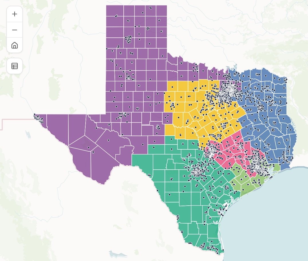
Split the state into six territories of whole counties, with about the same number of accounts in each.
Friday 9:40
She asks
One sentence and the account list. Then she goes back to the network model she was building.
- Six territories, balanced by accounts
Friday 9:52
The answer is back
Six territories of whole counties, within a handful of accounts of each other.
- Six territories, balanced by accounts
Which territory has the longest drives?
Friday 9:55
She asks the next question
The follow-up is answered on the same map. Nothing is set up again.
- Six territories, balanced by accountsCentral
Central
214 accounts · 38 counties
Monday 9:00
Everyone uses it
Each new rep opens the link and looks up their own patch.
Priya had fair territories before lunch.
Balancing territories by hand used to take her two days. She spent them on the network model only she can build, and every rep could see for themselves why their patch was fair.
The jobs this analysis gets done
- Compare a shortlist of sites before you signYour candidate sites, set side by side on who lives around them.
- Split accounts into fair sales territoriesEven territories from your account list, drawn on a map.
- Find where incidents really clusterHot spots tested, not just counted.
- See how much of your city each station reaches in timeDrive-time coverage, and the residents inside and outside.
- See how much two sites shareThe overlap between two catchments, and what a third would take.
- Find what share of residents can walk to a stopWalking access to a service, area by area.
What it costs
Mapstack is priced per person. Analysis is included for everyone, on the free plan too.
Free
$0for one person
Ask questions of your own files. The answers stay private to you until you choose to publish one.
Creator
$16a person a month, billed yearly
Adds sharing privately with your team, reports and prints of your results, and analyses that rerun without you.
Creator Max
$80a person a month, billed yearly
The same, with a larger monthly allowance for people who run analysis every day.
Colleagues who only need the answers take a Viewer seat at $10 a month. They open every result and ask it their own questions in plain words: “which area scores lowest?” See every plan.
Common questions
What kinds of analysis can Mapstack do?
What is within a distance or a travel time, and what is nearest. Counts and summaries by area or grid. Hot spots, outliers and clusters, tested against chance. Balanced territories and routes. Scoring places and choosing sites. Joining, clipping and overlaying layers.
Do I need to know which method to ask for?
No. Ask the question as you would ask a colleague and Mapstack chooses the method. If you do have a method in mind, name it and that is the one it runs.
How do I know the method is right?
Every answer comes back with the method, the settings and the sources written out, for your review. If you would have done it differently, say so and it is rerun your way.
How is this different from a chatbot writing me a script?
A script still has to be run, debugged and fed the right data, by you. Mapstack runs the analysis itself, on your data, and hands you the answer with its working.
Can I take the results back to the GIS I use now?
Yes. Every result is a dataset you can take out in standard formats that open in desktop GIS.
Is the data I upload private?
Yes, on every plan, Free included. Your files and the results made from them are private to you by default. Nothing is public unless you choose to publish it, and you can unpublish it again.
What happens to my data?
It stays in your workspace and it stays yours. Only the people you give a seat to can see it. It is not used to train AI, and when you delete it, it is removed.
Ask your first question.
Free to start. No card.