
Mapstack Apps and dashboards
The AI app builder for GIS work.
Describe the tool. Mapstack builds the web app or live dashboard from your data.
Free to start. Apps on a paid seat.
Watch an app get built
One request, start to finish: the job described in plain words, the app built and tested, handed back for your review.
Stop answering the same question. Hand over the tool.
Your AI teammate builds the app
From a description of the job to a working tool, handed back for your review.
Describe the job, not the interface
Say who the app is for and what they need to do with it. Mapstack designs the screens, so you skip the configuration and the code.
Built around one job
Its own search, its own panels, its own look. People get the answer they came for without learning to read a GIS.
Tested before you see it
Every build is opened in a real browser and tried at phone and tablet sizes. What reaches you already works.
Change it by asking
Move a panel, add a comparison, change the wording. The rest of the app stays as it was, and any earlier build is one step back.
Open to exactly who you choose
Private to your team until you publish. Then anyone with the link can use it, with no account and nothing to install.
A dashboard that stays current
When the screen has to follow the data, Mapstack builds it as a live map with charts and filters that refreshes on its own.
Not one template. The tool the job needs.
A dashboard builder gives everyone the same grid of widgets. Mapstack lays each app out around what its users are there to do.
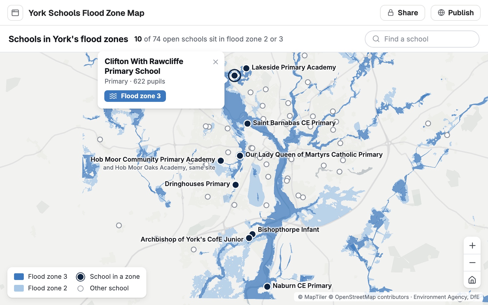
A lookup
Search for a place and see what applies to it.
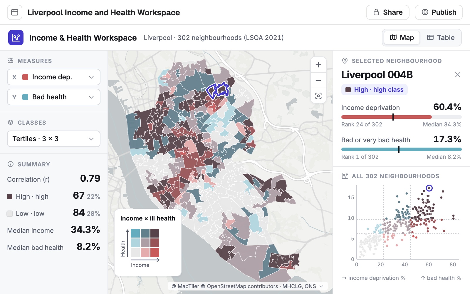
A workspace
Pick the measures, compare the areas, read the chart.
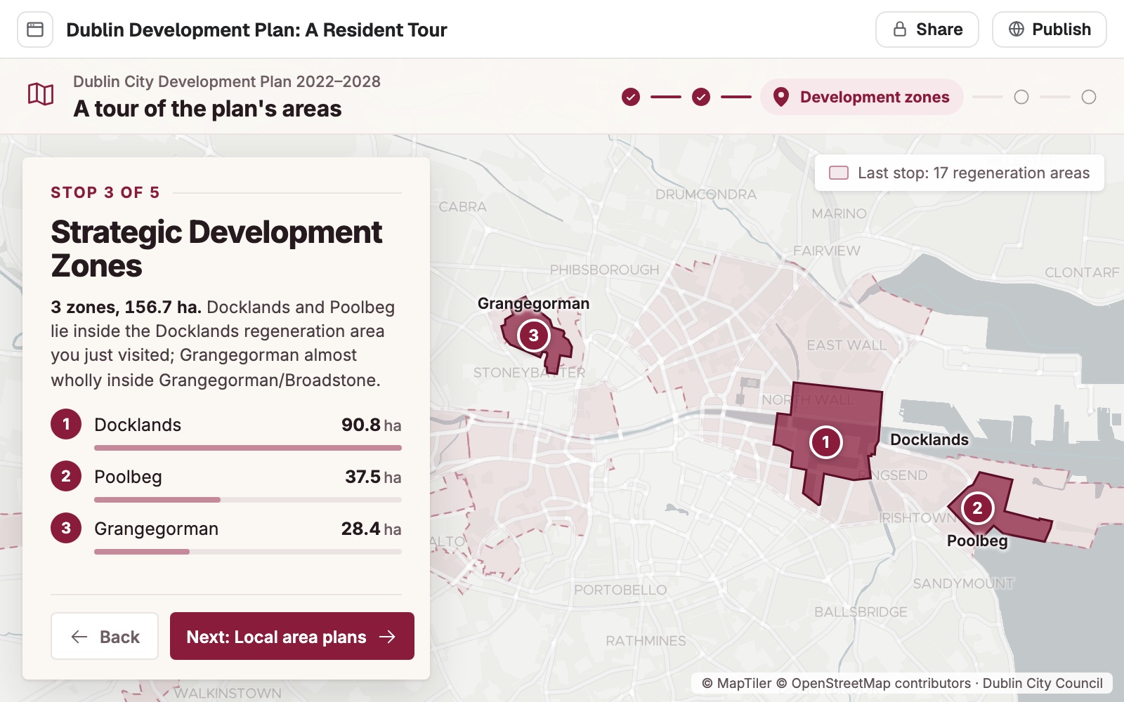
A guided tour
Walk people through a plan, one stop at a time.
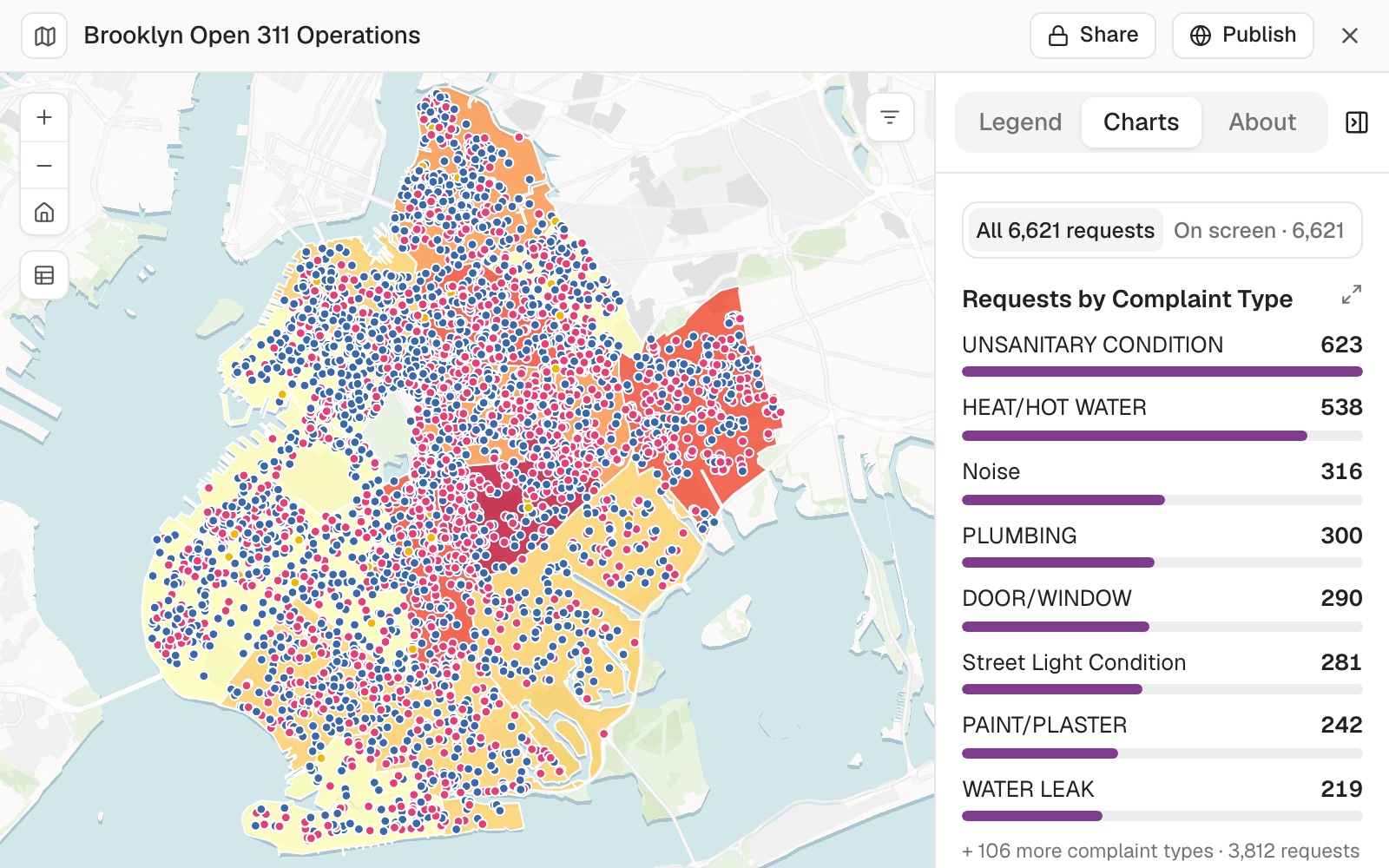
A live dashboard
Counts, charts and filters that follow the data.
Every app is built around one job
Here the job is “how well served is my area?” Everything on the screen is there to answer it, and nothing else is.
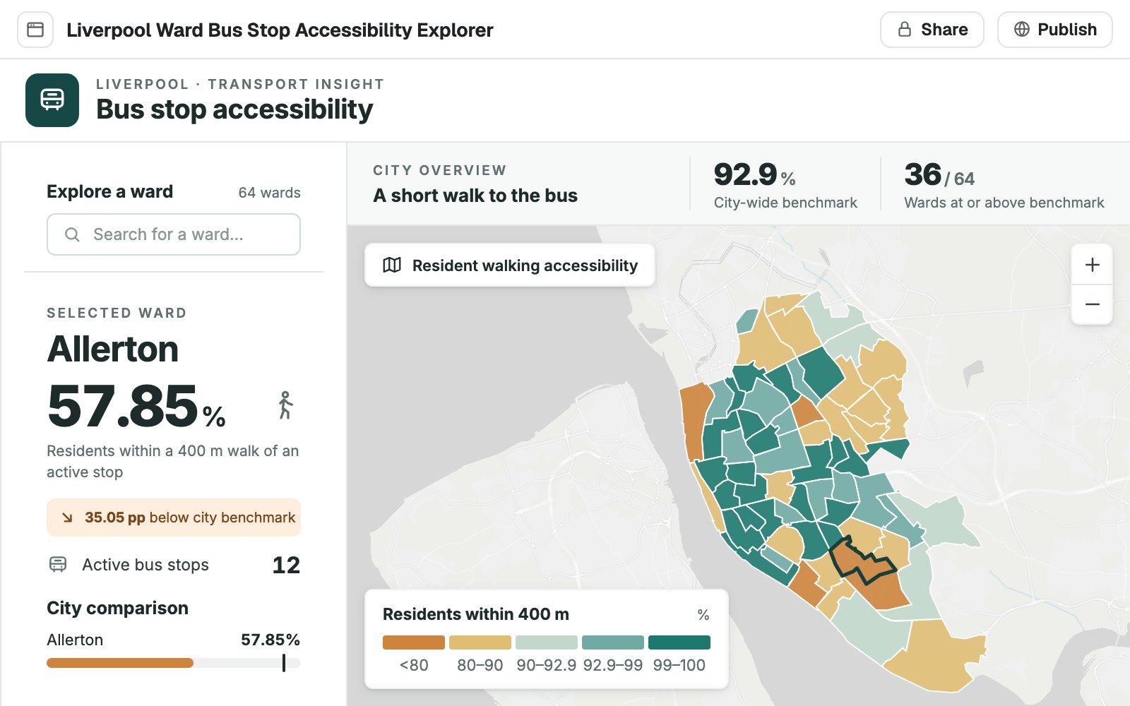
- Its own search. People find their place by the name they know it by.
- The figure they came for. Stated large, in plain words, for the place they chose.
- Set against the rest. How this place compares, so the number means something.
- The map, where it helps. There to show where, and to be clicked instead of searched.
- Private until you publish. Shared with your team by link, or opened to anyone.
Ask for the tool people keep asking you for
Four requests, as someone would type them, and what came back.
Let a team try the what-ifs themselves
Pretzel Hatch, a bakery chain planning its next openings
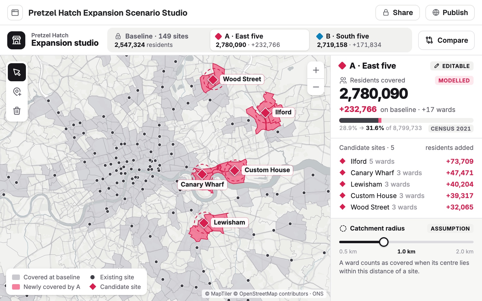
The request
Build a studio for the expansion team. They pick candidate sites, set a catchment radius, and see how many more residents each scenario reaches compared with today.
What came back
- Two scenarios to switch between and compare
- Residents added by each candidate site
- A radius the team can change for themselves
Walk a committee through the findings
A bike-share operator briefing its city’s transport committee
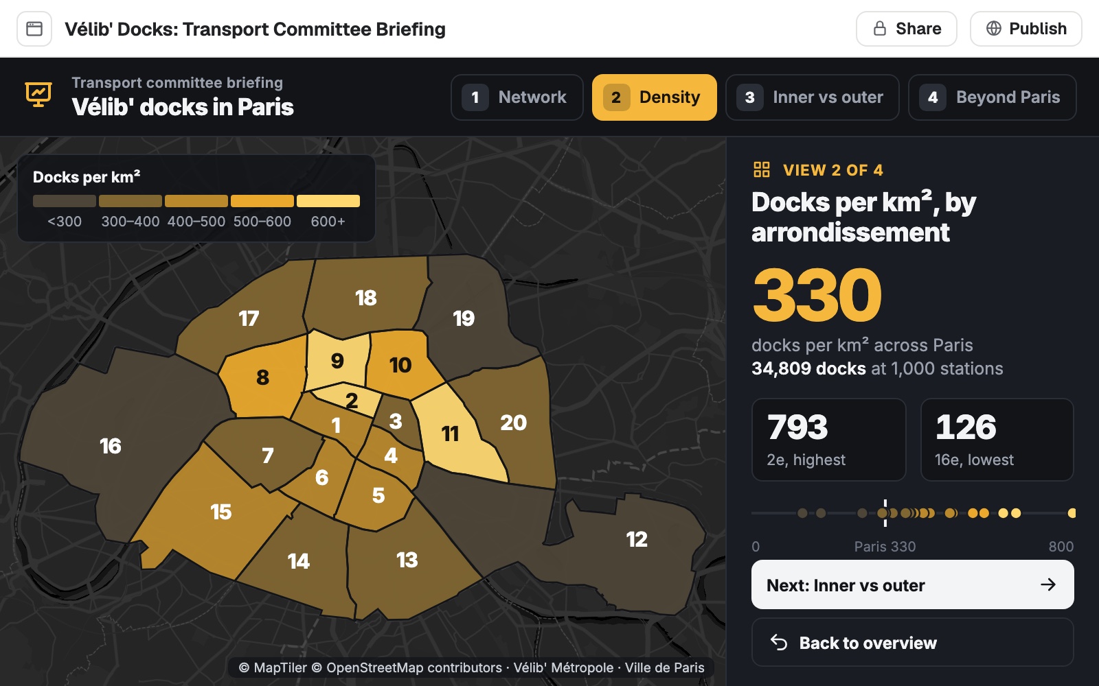
The request
Turn the dock density analysis into a four-step briefing for the committee: the network, density by district, inner against outer, and what lies beyond the city limits.
What came back
- Four steps, one finding on each
- The headline figure stated large
- A map that changes with the step
Put the day’s work on one screen
A city’s service-request team, watching the day’s open requests
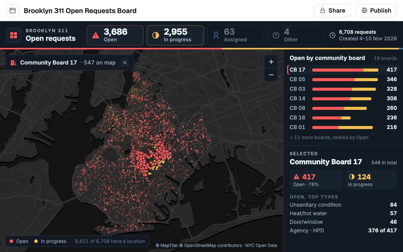
The request
Build a board for the control room from the open requests: totals by status across the top, the boards ranked by open requests, and click a board to see what is driving it.
What came back
- Open, in progress and assigned, counted
- Every area ranked, worst first
- Click an area to see its own breakdown
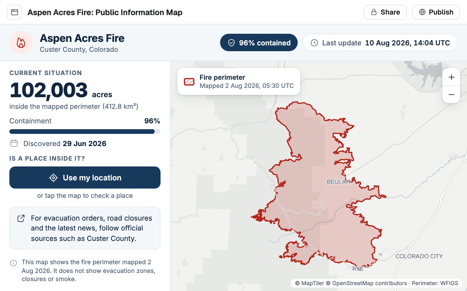
Give the public one clear answer
A county emergency office keeping residents informed during a wildfire
The request
Build a public page for the fire: the current perimeter, how much is contained, when it was last updated, and a way for people to check whether a place is inside it.
What came back
- The situation in three figures
- “Is my place inside it?” answered in one tap
- Laid out for a phone first
Built from the data you already have
Your datasets go in. A tool people can open comes out.
- What it is built fromAny dataset in your workspace, yours or one Mapstack found for you.
- Your own layers and tablesResults of an analysisBoundaries and census figuresPlaces and businesses
- What an app can holdWhatever the job needs, arranged for the people doing it.
- A mapSearchCharts and headline figuresFilters and comparisonsSteps and toursA file to download
- Where people open itIn a browser, from a link. Nothing to install.
- DesktopTabletPhoneA public link, no account
Mapstack builds it. You decide when it goes live.
You would try a colleague’s tool before you sent it round. It works the same way here.

- Private until you publish. Only your team can open an app until you choose to make it public.
- Checked before it reaches you. A build that does not load never goes live, and you are told when a check finds something to improve.
- Change one thing, keep the rest. Ask for an edit and only that part moves.
- Go back whenever you like. Every earlier build is kept, and going back to one can itself be undone.
- Asked, not assumed. When a request could mean more than one part of the app, Mapstack asks which.
An example of how it goes
Asked at 11:05. Built by 11:21.
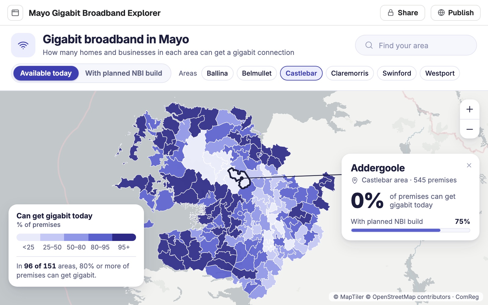
Aoife is the GIS analyst at a rural broadband provider. The support team asks her the same question forty times a week: can this area get gigabit yet?
- premises-by-area
Build an explorer for the support team: search an area, see what share of premises can get gigabit today.
Thursday 11:05
She describes it
Who it is for and what they need to see. Then she goes back to the build plan she was modelling.
Thursday 11:21
The app is back
Built, opened in a browser and tried at phone size before she ever saw it.
Add a switch for coverage after the planned build.
Thursday 11:25
She asks for one change
The switch is added. Everything else stays where it was.
- Addergoole
Addergoole
Today 0% · after the build 75%
Friday 9:00
Support uses it
The team looks up each caller’s area themselves, while they are still on the call.
Aoife stopped being the lookup service.
Forty interruptions a week became none. A tool like this had sat on her list for a year because building it meant a week she never had.
The jobs this gets done
- Build one screen that shows what is happening whereOpen work on a map, with charts and filters.
- Show residents how each area is doing against its targetA map of every area’s rate, and a plain-English report on who met it.
- Turn your figures into a story readers can followA headline, key points and short passages, each with a map or chart.
- Give buyers a map of a property sale listEvery parcel by kind, with the filters and pop-up a buyer needs.
- Make a visitor guide map of your town centreWhat to see, where to eat, toilets and car parks, on one map for phones.
- Map every building you hold, and the leases coming dueOwned and leased on one map, by when each lease ends.
What it costs
Mapstack is priced per person. Apps come with a Creator seat; the people who use them need no seat at all once an app is public.
Free
$0for one person
Make maps from your own files, with search, filters and charts built in. Private to you until you publish.
Creator
$16a person a month, billed yearly
Adds apps, dashboards that refresh on their own, reports, prints and private sharing with your team.
Creator Max
$80a person a month, billed yearly
The same, with a larger monthly allowance for people who build every day.
Colleagues who only use what you build take a Viewer seat at $10 a month. They open every private app and map in the workspace. A public app needs no seat. See every plan.
Common questions
What is the difference between an app and a map?
A map lets people explore your data, with a legend, search, filters and charts. An app is laid out around one job, with its own screens, wording and design, so someone who has never used a GIS gets their answer straight away.
Do I need to write code or configure widgets?
No. You say which data, who the app is for and what they must be able to do. Mapstack designs and builds it, and you change it by asking.
Does it stay up to date when my data changes?
A dashboard built as a live map follows its data and can refresh on its own, as often as every hour. An app is built from the data as it stood, and is brought up to date when you ask.
Who can open what I build?
Your team, until you publish it. Once you make it public, anyone with the link can use it in a browser with no account. You can make it private again at any time.
Does it work on a phone?
Yes. Every build is tried at phone and tablet sizes before it reaches you.
Which plan do I need?
Building apps needs a Creator seat. Live dashboards built as maps work on the free plan; having them refresh on their own needs a Creator seat.
Is the data I upload private?
Yes, on every plan, Free included. Your files and everything made from them are private to your workspace by default. Nothing is public unless you choose to publish it, and you can make it private again.
What happens to my data?
It stays in your workspace and it stays yours. Only the people you give a seat to can see it. It is stored in the United States, it is not used to train AI, and when you delete it, it is removed.
Describe your first app.
Free to start. Apps on a paid seat.