
Mapstack Sharing
AI map sharing for GIS teams.
Send the work as a link. The people who open it ask their own questions in plain words.
Free to start. No card.
Watch a map get handed over
One map, start to finish: made, checked, then sent to the people who need it in the form each of them wants.
Stop being the person everyone has to ask.
Your AI teammate handles the hand-over
From something on your screen to something a colleague can use, on your say-so.
One link, nothing to install
Colleagues and clients open your work in a browser. No licence to buy them and no file to explain.
They ask, Mapstack answers
People put their own questions to the map in plain words and get an answer from the data, so the follow-ups stop landing on you.
Private until you say so
Everything starts private to your team. Publishing is your decision, made on screen, and one click takes it back.
Always the current version
A shared map follows its data. Nobody is left working from last month’s attachment.
Seats for people who only look
A Viewer opens everything in the workspace and asks it questions, without a seat that makes things.
A file when a link will not do
Take it out as Word, PDF, an image or a GIS file, for the people and the systems that need one.
Every shared map answers for itself
The person who opens it does not need you beside them. What it shows, where it came from and what it means are all on the page.
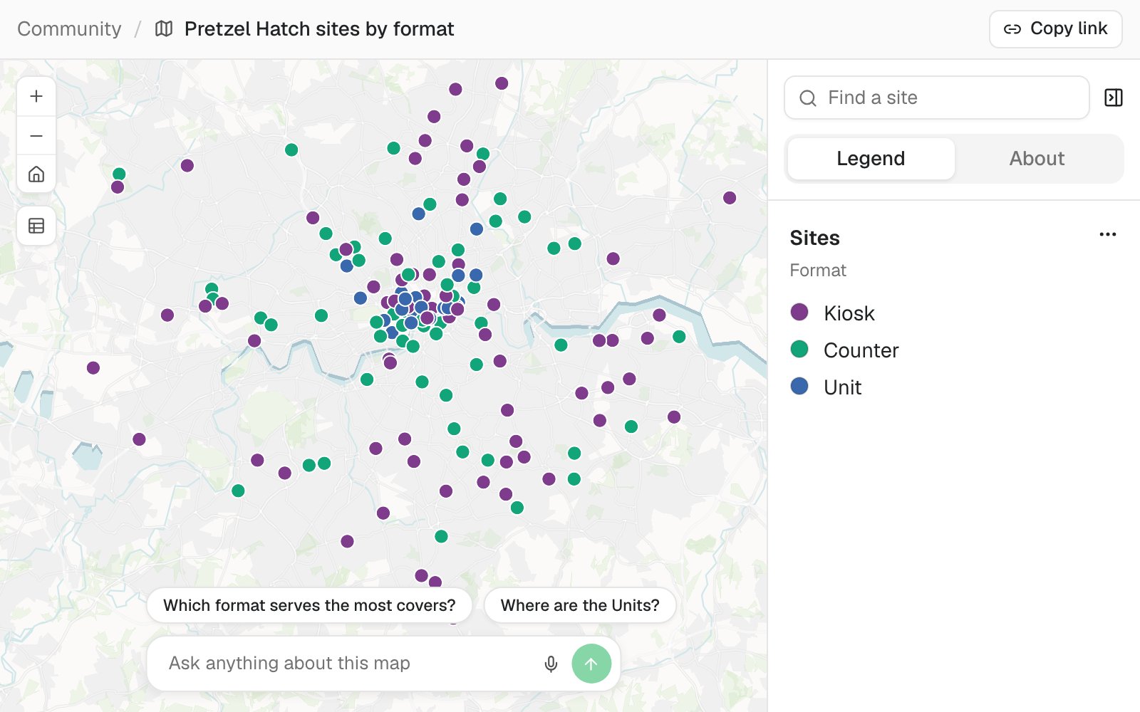
- A link to pass on. Anyone who has it can open the map. No account, nothing to install.
- Their place, found. Search for a site by the name they know it by.
- A legend in plain words. What the colours mean, and an About tab for the sources.
- Questions to start from. Suggested for this map, for people who do not know what to ask.
- Their own questions, answered. Asked in plain words, answered from the data behind the map.
Get your work to the people it is for
Four hand-overs, and what each person on the other end gets.
Give your team the whole workspace
Fieldwork, a planning consultancy working with a client’s team
The request
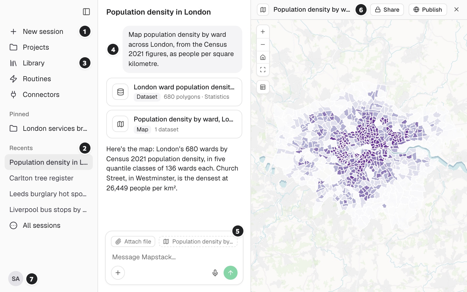
Map population density by ward for the client’s planning team. The four of them only need to look and ask questions, so I am adding them as Viewers.
What came back
- Every map, dataset and report open to them
- Their questions answered from the data
- Nothing they can change or publish by mistake
Send a client something they can open
Studio Marin, an architecture practice presenting a district
The request
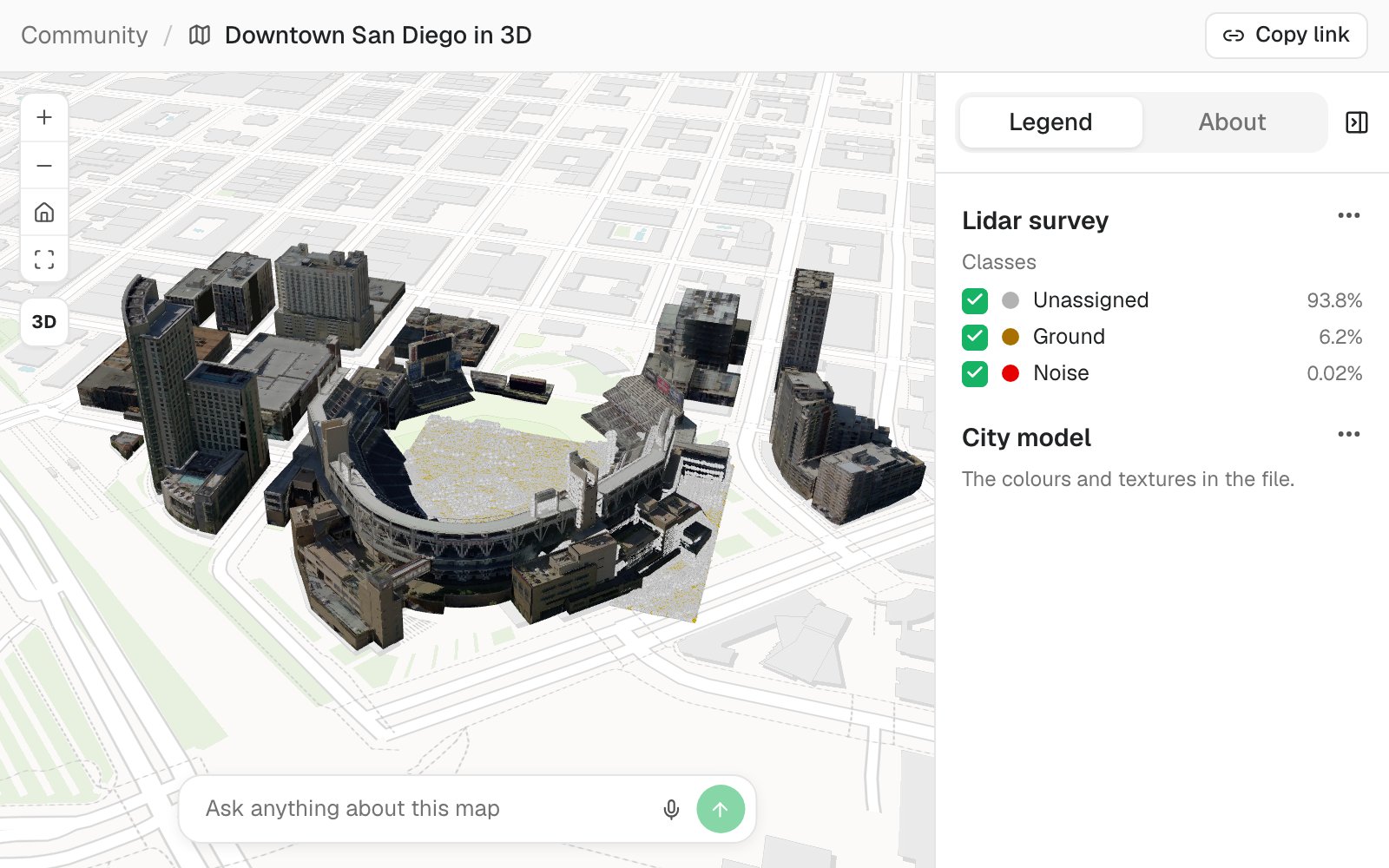
Get the downtown model ready for the planning panel, with a legend and the sources stated. I will publish it and email them the link before the hearing.
What came back
- A public page for the model, opened in a browser
- A legend and an About tab already on it
- A box for the panel’s own questions
Publish it for everyone
A city planning team consulting residents on its development plan
The request
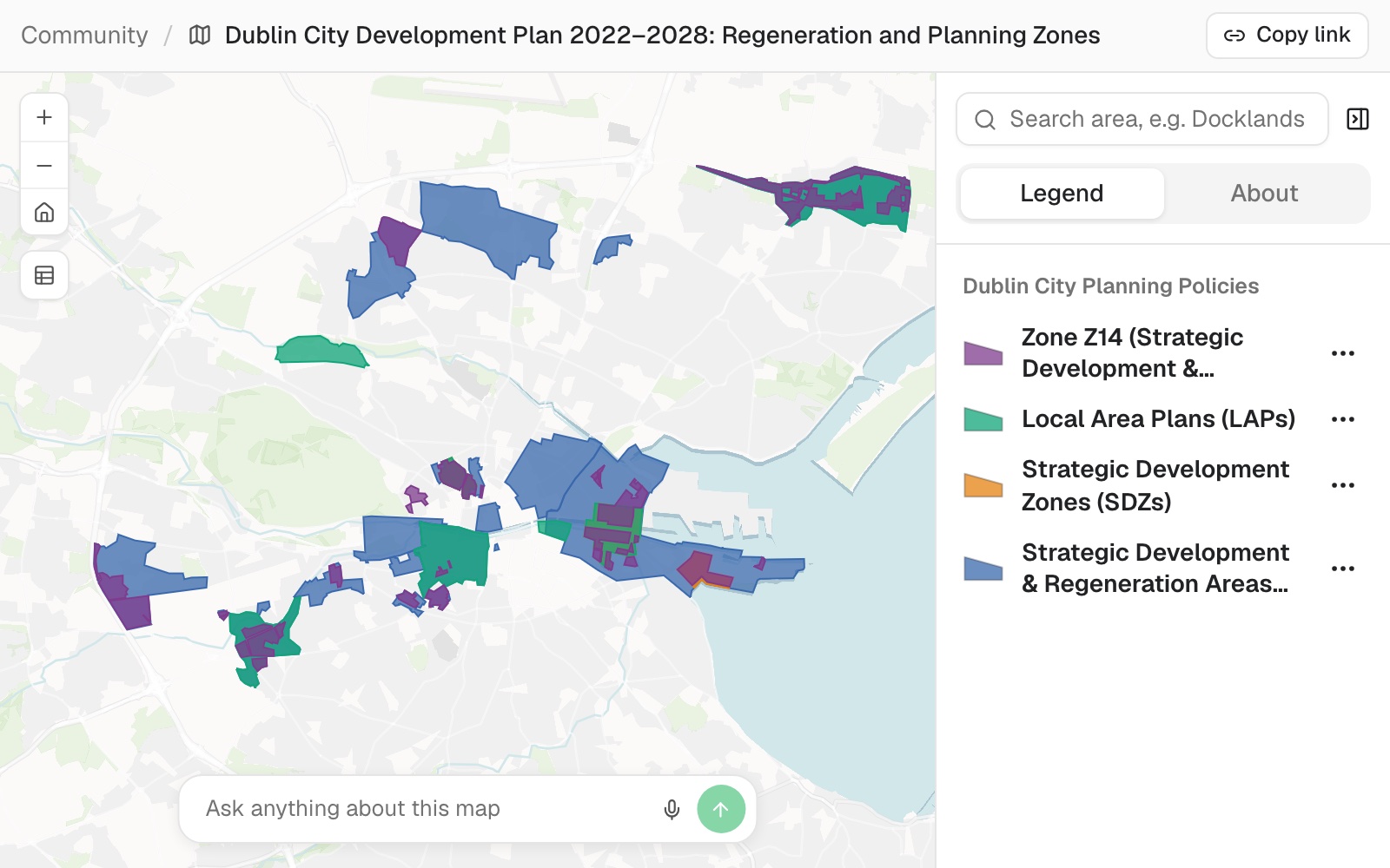
Get the plan layers ready for the consultation. Residents should be able to search for an area and see which policies apply to it. I will make it public on Monday.
What came back
- A public link, with no sign-in
- Each plan layer named in the legend
- Taken down again with one click when the consultation closes
Send the file when a link will not do
A bike-share operator briefing its city’s transport committee
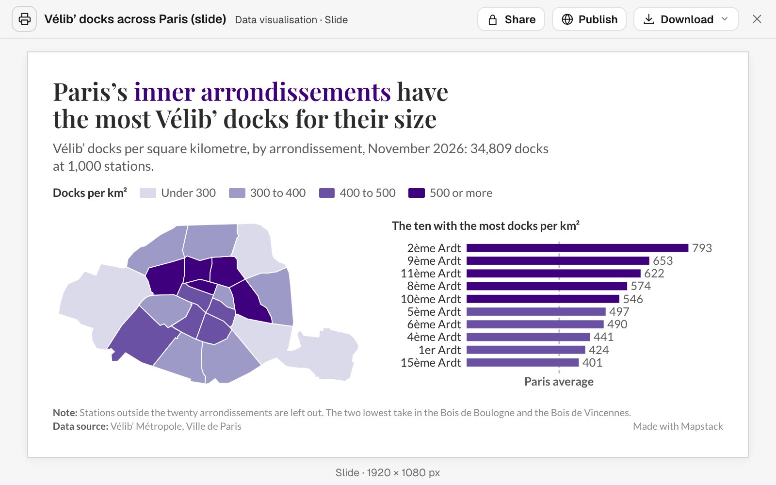
The request
The committee clerk needs it as a slide and the city’s GIS team wants the data. Give me the slide as a PDF and the districts as a GeoPackage.
What came back
- The slide, at slide size
- The data, in a format desktop GIS opens
- The same figures in both, because both come from one result
Reaches people however they work
A link for most. A file for the rest.
- Who can open itYou choose how far each piece of work travels.
- Your team, with a seatViewers, who look and askAnyone with the link, once public
- What they can do with itMore than look at a picture of a map.
- Search and filterRead the legend and the sourcesAsk their own questionsOpen it on a phone
- What you can send insteadFor the inbox, the deck and the other GIS.
- WordPDFPNGGeoPackageGeoJSONCSV
Mapstack answers. You decide who sees what.
Sharing is the one step that is always yours. Nothing leaves your workspace on its own.

- Private by default. Everything you make starts out visible to your workspace and nobody else.
- Publishing is your click. Mapstack never publishes or shares for you. You do it on screen, knowingly.
- Take it back whenever you like. Make a public page private again and the link stops working.
- Viewers cannot change your work. They open, ask and download. They cannot edit, publish or delete.
- Answers come from your data. When someone asks a question, Mapstack can show the rows behind the answer.
An example of how it goes
Shared at 10:07. No follow-ups since.
Sofia is the GIS analyst at a renewable-energy developer. Every week four project managers ask her which sites are at which stage, and every week she answers them one by one.
- project-sites.gpkg
Map our project sites, coloured by stage, for the project managers.
Monday 10:00
She asks for the map
One sentence and the sites file she already keeps.
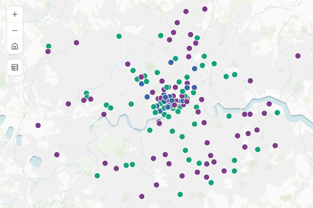
- Project sites by stage
Monday 10:05
The map is back
Every site coloured by stage, with a search box and a legend.
- Project sites by stage
Add the grid connection date to each site’s pop-up.
Monday 10:07
She adds a detail and shares it
One change, then a link to the four project managers.
- Project sites by stageAsked on the map
“Which sites are in permitting?”
14 sites, listed and highlighted
Tuesday 8:40
They ask it themselves
A project manager types a question into the map and gets the answer before Sofia is at her desk.
Sofia stopped fielding the follow-ups.
The weekly round of “which sites are…?” used to cost her an afternoon in small pieces. The project managers now ask the map, and it is never out of date.
The jobs this gets done
- Turn a map into a slide, a print or a linkFor people who will never open Mapstack.
- Share a map privately with a clientA Viewer seat to open it, filter it and ask it questions, changing nothing.
- Put a plan online for residentsOne public map, a display sheet and a plain page.
- Give your team one map of the whole operationEvery site by its rating, and the areas that need you first.
- Give a new rep a map of their patchEvery account on the districts they cover, a tap from its address.
- Publish open data as a map and a downloadYour portal export tidied, mapped by kind, with the licence and attribution on the map.
What it costs
Mapstack is priced per person. People who make things take a Creator seat; people who only look take a Viewer seat; the public needs no seat at all.
Free
$0for one person
Make maps from your own files and publish any of them with a public link. Private to you until you do.
Creator
$16a person a month, billed yearly
Adds sharing privately with your team, Viewer seats for colleagues, reports and prints.
Creator Max
$80a person a month, billed yearly
The same, with a larger monthly allowance for people who work in Mapstack every day.
Colleagues who only need to look take a Viewer seat at $10 a month. They open everything in the workspace, download it, and ask it their own questions in plain words. See every plan.
Common questions
Who can see what I make?
Only people with a seat in your workspace, until you publish something. A published page can be opened by anyone with its link. You can make it private again at any time.
Do the people I share with need an account?
Not for a public page: they open the link in a browser. To see private work, a colleague needs a seat in your workspace, and a Viewer seat is enough.
What can a Viewer do?
Open every map, dataset, report, print and app in the workspace, download them, and ask questions that Mapstack answers from the data. A Viewer cannot make, change, publish or delete anything.
Can people really ask a shared map questions?
Yes. A public map has a box for questions, with a few suggested to start from, and the answers come from the data behind the map.
Does a shared map update when my data changes?
Yes. A map is drawn from its data as it stands now, and the link stays the same. Reports and prints are dated records, so those stay as they were made.
Can I keep different clients apart?
Yes. Give each client or team its own workspace. A seat opens one workspace and nothing outside it.
Is the data I upload private?
Yes, on every plan, Free included. Your files and everything made from them are private to your workspace by default. Nothing is public unless you choose to publish it, and you can make it private again.
What happens to my data?
It stays in your workspace and it stays yours. Only the people you give a seat to can see it. It is stored in the United States, it is not used to train AI, and when you delete it, it is removed.
Make something worth sharing.
Free to start. No card.