
Mapstack Data
AI data preparation for GIS work.
Hand over the file. Mapstack cleans it, joins it and tells you what it changed.
Free to start. No card.
Watch a messy file get cleaned
One export, start to finish: handed over as it was, tidied and located, with a count of everything that changed.
Spend the day on the analysis, not the clean-up.
Your AI teammate does the data preparation
From the file as it arrived to data you can use, handed back for your review.
Hand it over as it is
Title rows, totals, odd encodings, a format from another system. Mapstack reads the file as it arrives, so you skip the tidying before the work.
Mapstack tells you what it changed
Rows in, rows out, what was repaired and what could not be placed. Every change is counted, so you can vouch for the result.
Joins without the fiddle
By a shared column, by location or both. Mapstack reports what matched and what did not, so a bad key never passes unnoticed.
The data you do not have, found
Boundaries, census figures, places and open datasets. Ask, and Mapstack goes and gets them, so you stop losing mornings to portals.
Change it by asking, or by hand
Describe an edit and it is applied to every row that fits, or move a single point yourself. Whichever is quicker.
Every version kept
Each change makes a new version and the old ones stay. Going back is one step, so trying something never costs you the original.
Every dataset explains itself
What it holds, where it came from and what was done to it, written down with the data. You are never left guessing at a file someone sent you.
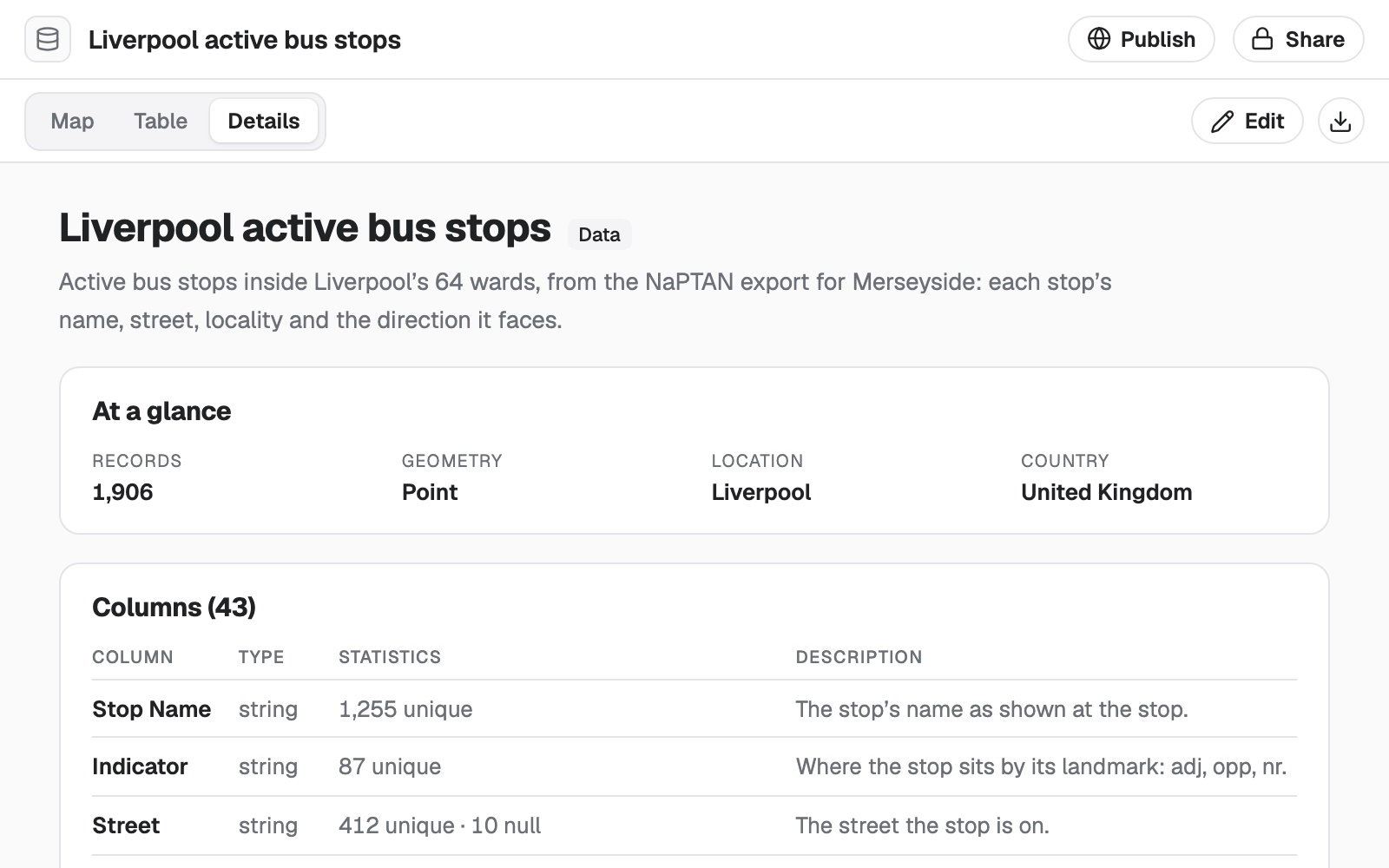
- What it is. A plain description of the data and where it came from.
- The facts at a glance. How many records, what kind of shapes, and where in the world.
- Every column, described. Its type, how many values it has and how many are missing.
- Three ways to look. On a map, as a table, or as these details.
- Yours to edit and take away. Change it here, or download it for your desktop GIS.
Hand over the jobs that eat your week
Four requests, as someone would type them, and what came back.
Turn a list of addresses into points
Tandem, an e-bike subscription company
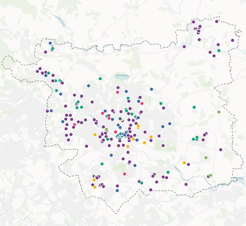
Match quality
How precisely each address was placed
- Premises · 3,612
- Street · 344
- Area only · 58
27 rows could not be placed. They are listed, not dropped silently.
The request
Attached is our customer export, about 4,000 rows. Locate every address, and tell me how good each match is so I know which to check.
What came back
- Every address placed, with the quality of its match
- The rows it could not place, listed with the reason
- A count of rows in, rows out and rows dropped
Join your table to the areas it describes
Tandem again, a week later
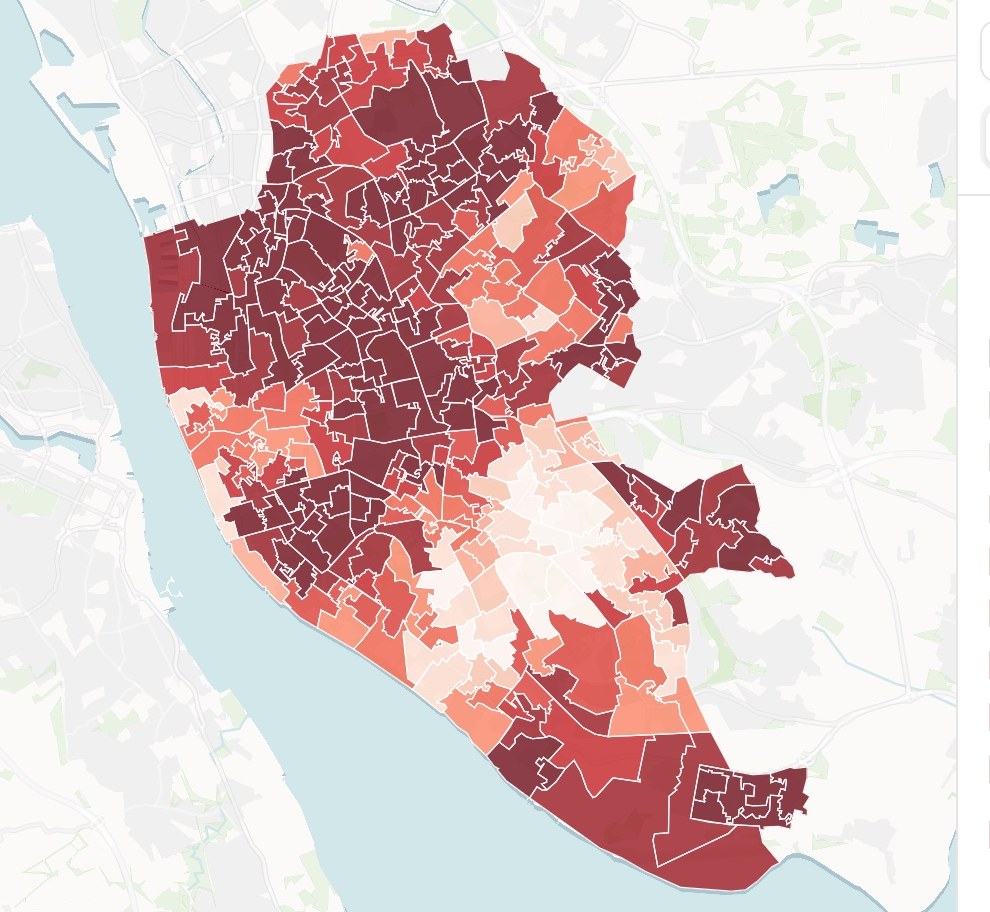
Subscribers
Per 1,000 residents
- 42 and above
- 30 – 42
- 19 – 30
- 9 – 19
- Below 9
The request
Join the located customers to the neighbourhood boundaries, add the resident population of each, and work out subscribers per 1,000 residents.
What came back
- Boundaries and population found and joined
- Every customer counted into its neighbourhood
- The unmatched rows reported, not hidden
Find the data you do not have
Hollow & Pine, a boutique-fitness brand scouting a new city
The request
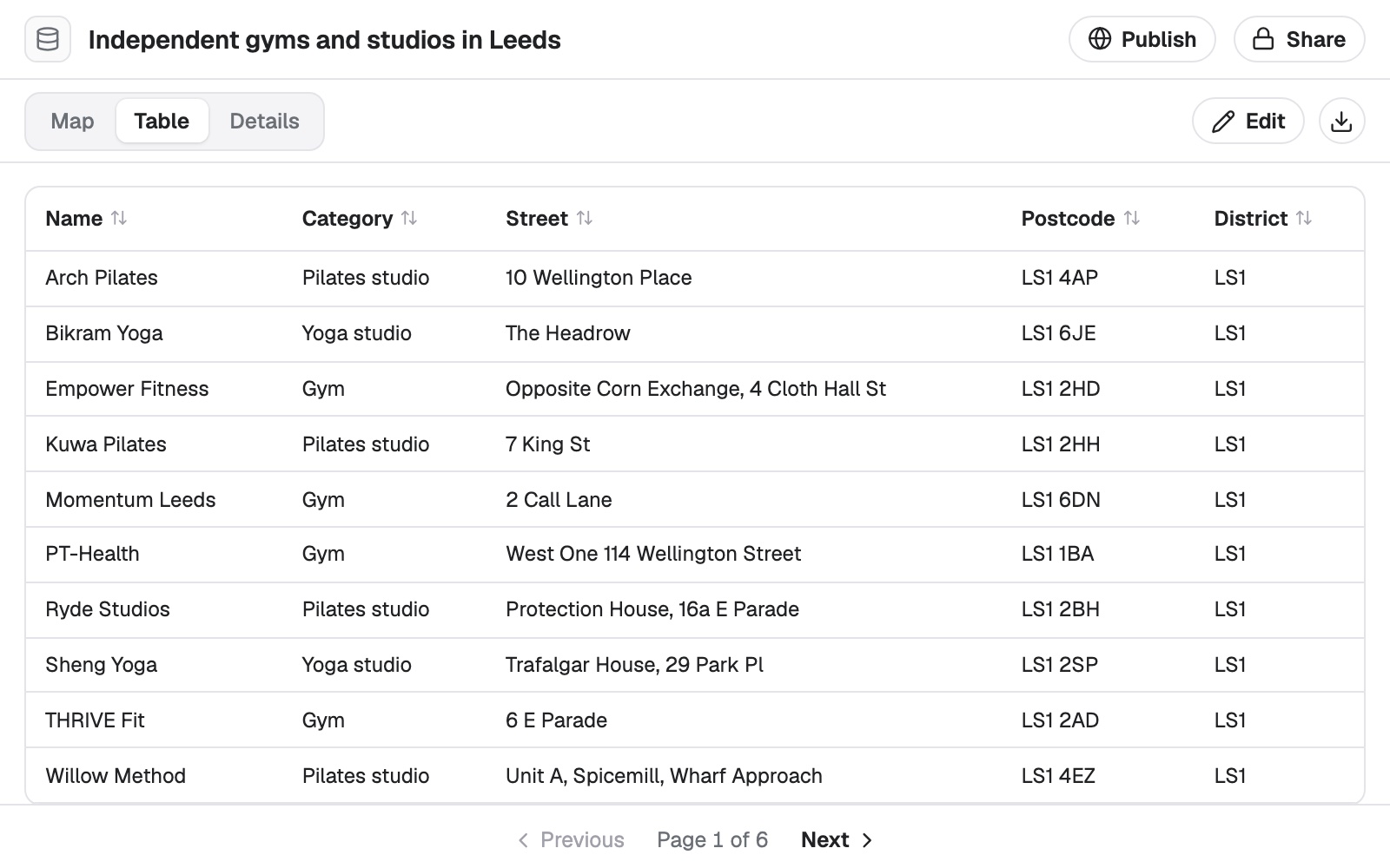
Find every independent gym and studio in Leeds, with its category, street and postcode. Leave out the national chains.
What came back
- A dataset of places, each with a confidence
- Duplicates merged or flagged
- The source named, with what it does and does not cover
Fix it by hand when that is quicker
Greenline, an urban tree-care contractor
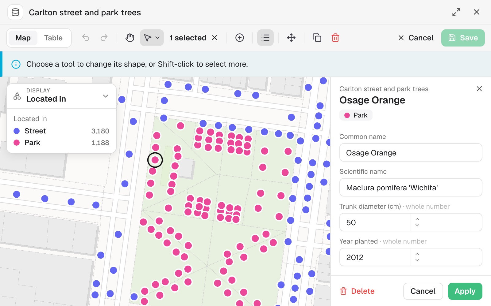
The request
Mark every tree planted before 1990 as due for inspection. I will correct the species on the few I checked on site myself.
What came back
- The rule applied to every row that fits
- Single records opened and corrected by hand
- Each change saved as a version you can go back to
Works alongside the GIS you have
Bring what you already hold. Take it back out when you are done.
- What you bringAttach it, paste it, or pick it from your cloud drive.
- ShapefileGeoPackageFile GeodatabaseGeoJSON, KML and GPXSpreadsheet or CSVGoogle Drive, OneDrive and Dropbox
- What Mapstack finds for youAsk, and it goes and gets it. That is time you do not spend searching.
- BoundariesCensus figuresPlaces and businessesOpen datasets from the web
- What you take awayThe data stays yours, in formats your desktop GIS opens.
- GeoPackageGeoJSONCSVA live map of the data
Mapstack prepares the data. You sign it off.
You would not pass on a colleague’s cleaned file without a look. It works the same way here.

- See every change. What was repaired, converted, dropped or left alone is listed with a count.
- Nothing is guessed in silence. The coordinate system is read from the file or asked for, and the dataset says which.
- The original is untouched. A join or a clean-up makes a new dataset. Your source stays as you gave it.
- Go back whenever you like. Earlier versions are kept, and restoring one never deletes the others.
- Asked, not assumed. Before an edit that would change most of a dataset, Mapstack checks with you.
An example of how it goes
Sent at 2:10. Ready by 2:16.
Tomás is the GIS analyst at an e-bike subscription company. Every month operations sends him the customer export, and every month it arrives in a slightly different shape.
- customers-november.xlsx
Clean this up, locate every address and tell me what you could not place.
Tuesday 2:10
He hands it over
One sentence and the export, as it arrived. Then he goes back to the coverage model he was building.
- Customers, located
Tuesday 2:16
The dataset is back
Every address placed and graded by how good the match is. The handful it could not place are listed with the reason.
- Subscribers per 1,000 residents, by neighbourhood
Join it to the neighbourhoods and count subscribers in each.
Tuesday 2:19
He asks for the join
Boundaries found, customers counted into each. Nothing is set up again.
- Subscribers per 1,000 residents, by neighbourhoodDownloaded as
GeoPackage
Opened in his desktop GIS
Tuesday 2:25
He takes it with him
The result goes straight into the model he was already working on.
Tomás skipped the clean-up.
The monthly export used to take him most of a morning before any real work began. He spent that morning on the coverage model, and he could say exactly what had been done to the data.
The jobs this gets done
- Clean up a messy file, with a logFiltered, placed and tidied, with every change counted.
- Put coordinates on every address in a listLatitude, longitude and how precisely each matched, in your own file.
- Join two tables, and see what did not matchMatched on a shared ID, counted on both sides.
- Join a table of figures to area boundariesYour figures, on the shapes they belong to.
- Get official boundaries and the figures for themBy name and edition, with the source of each part.
- Add area facts to every row of a customer listCensus income, age and household size, by address.
What it costs
Mapstack is priced per person. Bringing in, cleaning, joining and editing data is included for everyone, on the free plan too.
Free
$0for one person
Bring in your own files, clean them, join them and edit them. They stay private to you until you choose to publish one.
Creator
$16a person a month, billed yearly
Adds imagery and 3D files, sharing privately with your team, and data that is fetched again without you.
Creator Max
$80a person a month, billed yearly
The same, with a larger monthly allowance for people who prepare data every day.
Colleagues who only need to look take a Viewer seat at $10 a month. They open every dataset, download it and ask it their own questions in plain words: “how many rows have no postcode?” See every plan.
Common questions
Which file formats can Mapstack read?
Shapefile, GeoPackage, File Geodatabase, GeoJSON, KML and KMZ, GPX, MapInfo TAB, FlatGeobuf, GeoParquet, and spreadsheets as CSV or Excel. You can also paste rows straight in, or pick a file from Google Drive, OneDrive or Dropbox.
How does it handle coordinate systems?
It reads the coordinate system from the file. If the file does not say, it checks the coordinates against where the data should be, or asks you. The dataset records which of those happened, so nothing is placed on a guess you cannot see.
Can it geocode addresses?
Yes. Attach a list with an address column and each row is placed, with a note of how precise the match is: the premises, the street or the area. Rows it cannot place are listed, never put somewhere arbitrary.
How large a file can I bring?
A dataset holds up to 100,000 records, and spreadsheets and GIS files can be up to 50 MB each. A file over the limit is refused whole, never quietly trimmed.
Where does the data it finds come from?
From published sources: official statistics, open boundary sets, open data portals and open place data. Each dataset it brings back names its source, and Mapstack never makes data up to fill a gap.
Can I get my data back out?
Yes. Every dataset downloads as a GeoPackage, GeoJSON or CSV, which open in desktop GIS.
Is the data I upload private?
Yes, on every plan, Free included. Your files and everything made from them are private to your workspace by default. Nothing is public unless you choose to publish it, and you can make it private again.
What happens to my data?
It stays in your workspace and it stays yours. Only the people you give a seat to can see it. It is stored in the United States, it is not used to train AI, and when you delete it, it is removed.
Hand over your first file.
Free to start. No card.