
Damage assessment from a fire perimeter
Count the people and homes inside the burn area.
Attach the fire's perimeter. You get the people and homes inside it from the census, the schools, churches and businesses inside, and a map of the burn area.
Free to start. Reports and prints on a paid seat.
| Inside the burn area | |
|---|---|
| People living there | 227 |
| Homes standing there | 112 |
| The burn area, in acres | 89,989 |
People and homes inside the line at the 2020 census: homes that stood there, not homes lost.
For whoever writes the damage assessment
The fire is out and the perimeter is published.
The recovery request asks what was inside it: people, homes, towns, places.
Emergency managers, county planners and recovery teams all start from the same line. A wildfire perimeter is a shape; the census, the town limits and the places on the ground are the facts behind it.
Here you attach the shape. Mapstack lays it over the census and the places around it, and counts what falls inside.
One real fire
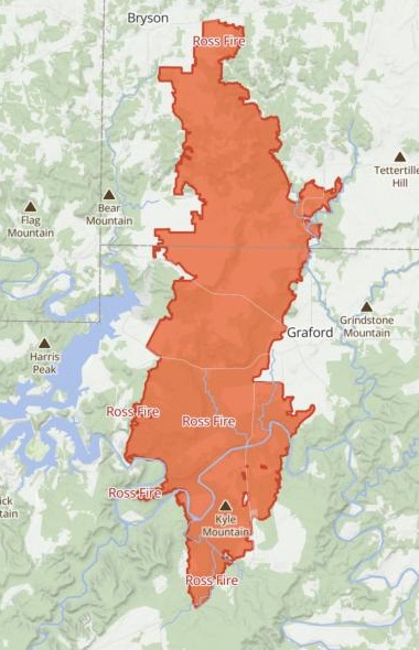
The Ross Fire burned between two towns, not into them
The final perimeter of the Ross Fire in Palo Pinto County, Texas, from the National Interagency Fire Center's public feed. Mapstack fetched the census, the town and community limits and the places itself.
- Towns reached
- Nonethe line crossed no town or community limits
- Places inside
- 3a general store, a florist and a chapel venue, all with Graford addresses
- Schools inside
- 0the nearest are in Graford and Mineral Wells
| The nearest towns | Miles from the edge |
|---|---|
| Palo Pinto | 0.36 |
| Graford | 0.61 |
| Mineral Wells | 6.91 |
People are counted where they live.
The census counts people and homes block by block. Where the line cuts a block, Mapstack counts only the share inside it (that is apportionment), so the figures are for the burn area, not the nearest town. Santo, Gordon, Mingus and Strawn lay farther off, 11.84 to 15.48 miles.
National Interagency Fire Center, WFIGS Interagency Fire Perimeters, the Ross Fire (US federal open data). People and homes: 2020 US Census. Town and community limits: North Central Texas Council of Governments. Places: Overture Maps. Run on 15 November 2026.
How it goes
You bring the perimeter. Mapstack brings the census and the places.
Attach the perimeter and say what the report needs.
Mapstack maps the burn area and counts what is inside it.
You get the summary to paste. Each figure with its source.
Go further
The same burn area, taken on to the next question.
Who lives there
Say who in the burn area may need help first.
- How many of the people inside the burn area are elderly?
- What is the household income across the burn area?
A sheet to submit
One page for the state and federal request.
- Make a printable briefing sheet of the burn area, A3, for our state and federal submission.
- Make the same briefing sheet letter-size, as a PDF.
A report to file
The figures and the map, written up.
- Write this up as a formal report.
Common questions
What happens to our perimeter file?
It stays in your workspace. Only people with a seat in your workspace can see it. Nothing leaves unless you publish it yourself.
It is not used to train AI. Your data and your conversations are not used to train AI models.
It is still yours. You keep ownership of what you bring in. Delete it and it is removed.
The full answer is in the documentation: Your data, privacy and security.
What does it cost?
Free to start. One seat, for you, with a starter amount of work each month. No card.
The counts, the map and the summary are on the free seat. With your own files and public sharing.
A printable sheet or a written report is on a paid seat. Paid seats are per person, and bring more work each month.
The prices are on the pricing page.
What does “inside” mean?
Homes standing, not homes lost. The census counts the homes (housing units, in its words) inside the line in 2020. It does not say which burned.
Close is not inside. A town is reached only if the line crosses its limits. For the rest you get the distance.
Places from open data. Businesses, churches and schools, with their names and addresses.
Count what is inside yours.
Free to start. Reports and prints on a paid seat.