
Drive-time analysis around a site
See who and what is within reach of your site.
Name the site and the drive times. You get each drive time drawn along the roads, with the households and competitors inside it.
Free to start. Reports on a paid seat.
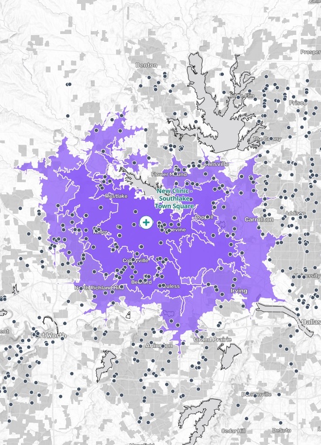
| On the map | |
|---|---|
| The new site, placed from its name | |
| The 10, 15 and 20-minute drives, nested | |
| Vet clinics and animal hospitals across the metro | 3,617 |
| Grey: built-up land and lakes on the base map |
Within a 10-minute drive: 44,627 households, and 46 competitors already there.
For whoever has to size up a site
A lease signed, a launch to plan.
How many households can reach you in ten minutes, and who is already there to serve them?
The area you can reach in a set time is a drive-time catchment area; retailers call it the trade area, and mapping people call it an isochrone, or a drive-time map. It follows the roads, not a circle.
Here you name the site and the times in a sentence. Mapstack fetches the households and the competitors itself.
One real site
A new clinic, three drive times, every rival counted
A new veterinary clinic at Southlake Town Square, Texas, named in the request with no file attached. Mapstack fetched the latest census households and the vet clinics and animal hospitals around it.
- Households
- 423,712within a 20-minute drive, from the latest census
- Competitors
- 169vet clinics and animal hospitals already inside that drive
- Reach
- 1,140 km²covered by the 20-minute drive, along the roads
| Drive time | Households | Vet clinics and animal hospitals |
|---|---|---|
| 10 minutes | 44,627 | 46 |
| 15 minutes | 184,938 | 94 |
| 20 minutes | 423,712 | 169 |
Each drive time takes in the one before it.
So the 20-minute figures include everyone and everything within 10 and 15. The households come from census block groups, shared out by how much of each falls inside a drive time, and the answer said so.
Households: US Census Bureau, American Community Survey 2023 5-year estimates, by block group. Vet clinics and animal hospitals: listed places across Dallas–Fort Worth, fetched by Mapstack. Drive times along the road network. Run on 14 November 2026.
How it goes
You bring the place and the times. Mapstack sets out its plan, then brings the roads, the households and the competitors.
Name the site and the drive times.
Mapstack draws the drive times and places every competitor.
You get one small table.
The reach is where it starts
Mapstack offered these next. Each of them is something you can ask for today.
Know the households
For the mailing.
- Break each drive time down by household income.
Take the numbers
Into your own plan.
- Make the summary table a dataset I can download.
Hand it on
For the people planning the launch.
- Write it up as a launch report.
Common questions
What happens to our site details?
It stays in your workspace. Only people with a seat in your workspace can see it. Nothing leaves unless you publish it yourself.
It is not used to train AI. Your data and your conversations are not used to train AI models.
It is still yours. You keep ownership of what you bring in. Delete it and it is removed.
The full answer is in the documentation: Your data, privacy and security.
What does it cost?
Free to start. One seat, for you, with a starter amount of work each month. No card.
The drive times, the counts and the map are on the free seat. With your own files and public sharing.
A written report is on a paid seat. Paid seats are per person, and bring more work each month.
The prices are on the pricing page.
How is reach measured?
Along the roads. Each drive time is drawn out from the site along the road network.
Households from the census. The latest American Community Survey, fetched for you block group by block group.
Each band opens up. Click a drive time for its households and competitor count. Charts sit beside the map.
Map your reach.
Free to start. Reports on a paid seat.