
A location map for visitors
Make a "find us" map for your venue.
Name your venue. You get a web map for your site and a print for your leaflet, with the 5, 10 and 15-minute walk and what is nearby.
Free to start. Leaflet prints on a paid seat.
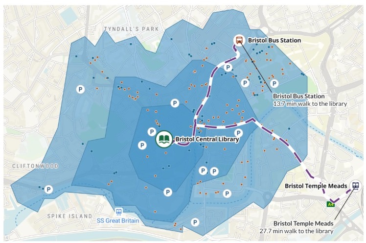
| On the leaflet | Drawn as |
|---|---|
| Bristol Central Library | A book |
| Walking routes from the stations | Dashed line |
| Bus stops | Square |
| Cafés and coffee shops | Dot |
| Public car parks | P in a circle |
| Walking zones | Darkest nearest |
The same message made a web map for the website, from the same data.
For whoever tells people how to find you
Libraries, museums, venues, offices.The "find us" page needs a map.So does the leaflet in the foyer.
Both should show the same way in.
Each zone is drawn along the streets and paths, so it shows how far people really get on foot, not a circle round the door. Mapping people call these areas isochrones; on a "find us" page it is a walking distance map.
The print comes with a title, a key, a note on how to read it and a source line, ready for the back of a leaflet.
One real library
Everything a visitor needs, within a walk of the door
Bristol Central Library on College Green, asked for in one message with nothing attached. Mapstack placed the library and both stations, drew the walking zones and fetched the rest.
- By bus
- 115stops within the walking zones
- By car
- 15car parks within the walking zones, with their spaces in the web map
- For a coffee
- 145cafés and coffee shops within the walk
| What it fetched | Within the walk | Across Bristol |
|---|---|---|
| Bus stops | 115 | 1,680 |
| Cafés and coffee shops | 145 | 510 |
| Car parks | 15 | 51 |
It keeps to the walk.
Mapstack fetched each kind across the city, then kept only what sits inside the walking zones, so the map shows what a visitor can reach on foot.
Bus stops and car parks: open data for Bristol. Cafés and coffee shops: Overture Maps. Walking zones and routes along the street and path network. Run on 15 November 2026.
Put the walk from the station on the leaflet
Ask for the minutes in print, and each station gets its own.
Print the walk time from each station on the leaflet, beside the station.
Mapstack worked the walking figures into the print and put a callout at each station, joined to it by a line: "Bristol Bus Station, 13.7 min walk to the library". In its reply it gave the distance too: 1.1 km, about 14 minutes.
How it goes
You name the place. Mapstack finds what is around it and makes both versions.
Name your venue and the stations people arrive at.
Mapstack draws the walk and finds what is nearby.
You get two versions.
Common questions
What happens to our maps?
It stays in your workspace. Only people with a seat in your workspace can see it. Nothing leaves unless you publish it yourself.
It is not used to train AI. Your data and your conversations are not used to train AI models.
It is still yours. You keep ownership of what you bring in. Delete it and it is removed.
The full answer is in the documentation: Your data, privacy and security.
What does it cost?
Free to start. One seat, for you, with a starter amount of work each month. No card.
The web map and its link are on the free seat. With your own files and public sharing.
The leaflet print as a PDF or PNG is on a paid seat. Paid seats are per person, and bring more work each month.
The prices are on the pricing page.
How do visitors open the web map?
You publish it. Select Publish at the top of the map and set it to Public.
A link on your page. Put the link on your "find us" page.
Tools for the visitor. Search, layers to switch on and off, distance measuring and a choice of base map.
Make yours.
Free to start. Leaflet prints on a paid seat.