
Market potential by area
See where the people you want to reach live.
Name who they are and the place. You get a map of how many live in each area and their share of the population, from the census.
Free to start. No card.
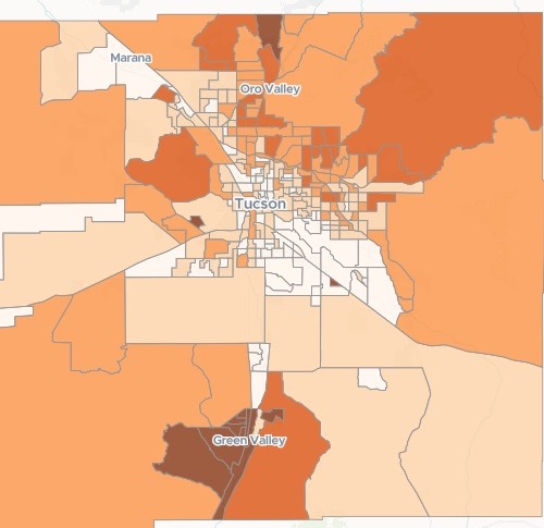
| Share aged 65 and over | Share |
|---|---|
| Highest | 65.6% and above |
| High | 35.6% to 65.6% |
| Middle | 23.3% to 35.6% |
| Low | 13.3% to 23.3% |
| Lowest | Below 13.3% |
The darkest tracts sit around Green Valley, south of Tucson; the next shade runs across the foothills to the north-east.
For whoever plans the campaign
A direct mail campaign.A local ad.An open day.You know who you want to reach.
The question is where they live.
The census counts people by age, area by area. A census tract is a small area the Census Bureau reports on; a ZIP code is the area a mail house works by.
Here you name the audience and the place. Mapstack fetches the figures and maps them. Some call it market potential; for a mailing, it is demographics by ZIP code.
One real campaign
A hearing clinic, and the tracts to mail
A clinic in Tucson, Arizona, offering free hearing checks by post to people aged 65 and over. Nothing was attached: Mapstack fetched the census figures for every tract in Pima County.
- Areas
- 270census tracts, each with its count, its share and its total population
- Named
- 13tracts with the highest shares, each with its count and total
- Lowest of the 13
- 65.55%aged 65 and over in Tract 44.04, the last tract named
| Census tract | Share aged 65 and over | Aged 65 and over |
|---|---|---|
| Tract 43.24 | 91.38% | 2,491 |
| Tract 41.30 | 89.13% | 1,722 |
| Tract 43.28 | 88.85% | 3,188 |
| Tract 43.32 | 83.87% | 1,503 |
| Tract 41.33 | 83.62% | 2,027 |
It reads the codes back as places.
From its own knowledge, and saying so, it placed the 43 series of tracts in Green Valley and Sahuarita, retirement communities south of Tucson. It said the figures are sample estimates, with margins of error on small tracts, so a mailing does best on clusters of neighbouring tracts that are all high.
US Census Bureau: American Community Survey 5-year estimates, 2019–2023, by census tract; 2020 Census, Demographic and Housing Characteristics, by ZIP code. Fetched by Mapstack. Run on 14 November 2026.
Rank the ZIP codes for your mail house
Ask for the areas your vendor works by. They are added to the same map.
It names the source for the ZIP codes, the 2020 Census, and notes that its small counts carry slight statistical noise.
The ones it called efficient targets pair a large count with a high share: 85704, 85718, 85750 and 85755.
Our mail house works by ZIP code. Give me a ranked list of the ZIP codes in Pima County: how many people aged 65 and over live in each and what share of the population they are, biggest numbers first, and show the ZIP codes on the map too.
All 52 ZIP codes, ranked, and a ZIP code layer on the map with each one labelled. 85614, Green Valley, leads by a wide margin: 17,714 people aged 65 and over, 68.69% of its residents. 85710 has the second most, 13,569, in a populous ZIP code where they are 23.65%.
How it goes
You name the audience. Mapstack brings the figures.
Say who and where, in a sentence.
Mapstack maps every area by its share.
You open any area for its people aged 65+ and their share.
Common questions
Where do the figures come from?
The census, fetched for you. Name the people and the place; there is no table to find first.
The source and the year, stated. In the reply, for every level you ask for.
How far to trust them. Sample estimates carry margins of error, and it says where they matter.
What does it cost?
Free to start. One seat, for you, with a starter amount of work each month. No card.
This job is on the free seat. Maps, datasets, analysis, your own files and public sharing are all included.
Pay per person for more. A paid seat brings more work each month, and seats for your team.
The prices are on the pricing page.
What is on the map?
Every area, shaded. Tracts by share, ZIP codes by count, each switched on and off in the legend.
The figures behind each. A chart of the shares, and a table you can sort.
The places, named. ZIP codes labelled on the map.
Find yours.
Free to start. No card.