
Competitor mapping
See which brand leads in every area.
Name your brand, your competitors and the region. You get a count of shops area by area, and a map coloured by the brand that leads each. Nothing to attach.
Free to start. No card.
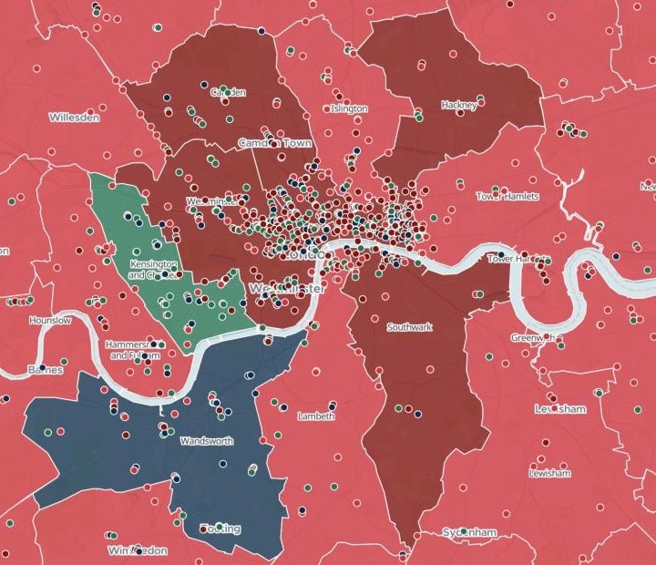
| The chain with the most shops | Leads |
|---|---|
| Chain A | The outer boroughs |
| Chain C | The centre |
| Chain B | Kensington and Chelsea |
| Chain D | Wandsworth |
Each borough takes the colour of its leading chain; each shop is drawn on top in its own chain’s colour.
For whoever writes the competitor review
Strategy teams.Franchise planners.The shops are public.
Counting them by area is the work.
Competitor mapping usually means a list of addresses for each brand, a set of boundaries, and a great deal of counting.
Here you name the brands and the region. Mapstack finds the shops, counts every brand in every area, and shows the leader on one map.
One real market
Four coffee chains, 33 London boroughs
A strategy team at a coffee chain, reviewing its rivals across Greater London, the City of London counted as one borough. Nothing attached: Mapstack found the shops of four coffee chains itself.
- Shops
- 1,368of the four chains, each counted in its borough
- Chain B
- 322shops, more than Chain C’s 306, yet it leads one borough to C’s five
- The largest
- 541shops of Chain A, the most of the four
- Chain A leads
- 26
- Chain C leads
- 5
- Chain B leads
- 1
- Chain D leads
- 1
More shops is not more boroughs.
Chain C’s shops crowd the centre: 80 of the 203 in Westminster, 43 of the 91 in the City.
Shops: Overture Maps, fetched by Mapstack, closed sites left out. Boroughs and resident population fetched by Mapstack. Run on 14 November 2026.
How it goes
You name the brands. Mapstack finds and counts the shops.
Name the brands and the region, in a sentence.
Mapstack colours each area by its leader.
You get every brand’s count in every area.
Take it further
Who leads where is the first page of the review. Each of these is a request you can send today.
Against the people
A lead in shops is not a lead per resident.
- Compare each brand's shops with each borough's resident population: where is each brand dense, and where is it thin?
Where we are missing
From counting to coverage.
- Map the travel-time coverage of our shops, and the gap areas outside it.
Common questions
Where do the shops come from?
Found for you. From Overture Maps, an open map of places. You attach nothing.
Closed shops left out. And listings for the same shop merged into one.
The areas fetched too. With each one’s resident population added.
What does it cost?
Free to start. One seat, for you, with a starter amount of work each month. No card.
This job is on the free seat. Maps, datasets, analysis, your own files and public sharing are all included.
Pay per person for more. A paid seat brings more work each month, and seats for your team.
The prices are on the pricing page.
What is on the map?
Each area, by its leader. Select one for every brand’s count there.
Every shop. Each in its brand’s colour, with a filter by brand.
Search. By area, shop name or address.
Map yours.
Free to start. No card.