
Catchment overlap and cannibalisation
See how much of a catchment two sites share.
Name the sites. You get the area within a drive of each (its catchment area) on one map, with the people in each and the people in both.
Free to start. No card.
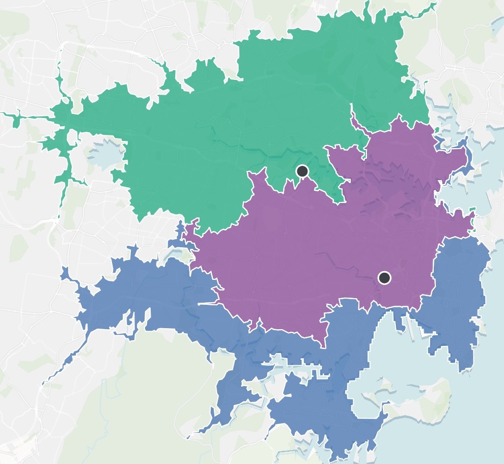
| People within 30 minutes | People |
|---|---|
| Of Rhodes | 2.23m |
| Of Tempe | 1.99m |
| Of both | 1.29m |
Between them the two stores reach 2.93 million people.
For whoever has to say what a new site costs the old ones
A new site always looks good on its own.
The awkward question is how many of its customers you already have.
The usual answer is two circles on a map and an argument about how much they overlap.
This measures both catchments along the roads, counts the people they share, and shows its assumptions.
One real comparison
Two stores, 2.93 million people, more than half of them shared
Two large stores in Sydney, at Tempe and at Rhodes, each with the area a car can reach in 30 minutes. Nothing attached: Mapstack found the stores and the population itself.
- Reached
- 2.93mpeople within 30 minutes of one store or the other
- Shared
- 1.29mpeople within 30 minutes of both
- The overlap
- 65%of Tempe's catchment, and 58% of Rhodes'
| Within 30 minutes | People |
|---|---|
| Of Rhodes | 2.23 million |
| Of Tempe | 1.99 million |
| Of both | 1.29 million |
It says how it counted, because the edge of a catchment never lines up with the census.
Here it counted by mesh block, the smallest area the census publishes: a block counts when its centre is inside the catchment, so the edge is close to exact.
Population: Australian Bureau of Statistics, 2021 Census. Drive times on the road network. Run on 11 November 2026.
Test a third site before you sign
A gravity model (the Huff model is the common one) shares the people in each small area between the sites: nearer and bigger wins more. Ask for one.
Mapstack states what it assumed: here, equal pull for all three stores, and attraction falling with the square of drive time.
If a third store opened at Parramatta, how many people would it pull from each store? Use a gravity model, count each person once, and say what you assumed about each store's pull.
Parramatta would draw about 874,000 people away from the two existing stores: 523,000 from Rhodes and 351,000 from Tempe. On top of those, it would reach 648,000 people who had no store within 30 minutes before.
How it goes
You name the sites and the drive time. Mapstack does the routing and the counting.
Name the two sites and how far people travel to them.
Mapstack draws each catchment and counts the people in each, and in both.
You test a third site, and see what it would take.
The step-by-step guide is in the documentation: Compare two catchments: who they share, and what a new site would take.
Common questions
What does it cost?
Free to start. One seat, for you, with a starter amount of work each month. No card.
This job is on the free seat. Maps, datasets, analysis, your own files and public sharing are all included.
Pay per person for more. A paid seat brings more work each month, and seats for your team.
The prices are on the pricing page.
How is it measured?
Along the roads. A drive catchment is the area a car can reach in the time, on the road network.
Each person once. Census population, counted by the smallest areas published.
Assumptions stated. What each site's pull was taken to be, and how fast it falls with distance.
Before and after tables. Side by side, so the method stays with the numbers.
Compare yours.
Free to start. No card.