
Compare locations by nearby amenities
Compare places by what is within a walk of each.
Name your shortlisted sites with their postcodes, and the amenities that matter. You get the sites side by side: what is within a 10-minute walk of each, and a map.
Free to start. Written reports on a paid seat.
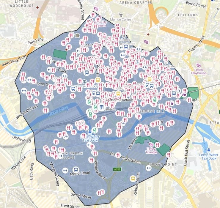
| Nurseries within a 10-minute walk | Nurseries |
|---|---|
| Platform, city centre | 4 |
The shape is a 10-minute walk along the streets, with the places inside it on top.
For whoever has to choose between places
Three offices on a shortlist.Two flats to rent.A plot for a new nursery.The brochure gives the rent.
It does not tell you what is around each one.
The area you can walk in ten minutes is a walking catchment. It follows the streets, not a circle.
Name the places and the kinds of place that matter. Mapstack finds them across the city, counts what falls inside each walk, and puts the sites in one table.
One real shortlist
Three offices in Leeds, five kinds of place, one table
An engineering consultancy of 60 people choosing between three office sites, named with their postcodes and nothing attached. Mapstack placed them and fetched every kind of place for the city itself.
- Platform, city centre
- 516places to eat within a 10-minute walk
- Thorpe Park
- 10places to eat within a 10-minute walk
- Kirkstall Forge
- 1place to eat in its walk, measured from the station
| Site | Gyms in the walk | The nearest gym |
|---|---|---|
| Platform | 33 | LivingWell, 0.16 km |
| Thorpe Park | 1 | Pure Gym, 0.42 km |
| Kirkstall Forge | 0 | Kirkstall Leisure Centre, 1.59 km |
It gives the nearest, even outside the walk.
Kirkstall Forge has no gym inside its walk. The table still names the nearest, Kirkstall Leisure Centre: about 20 minutes on foot.
Places to eat, gyms, nurseries, stations and stops: listed places in Leeds, fetched by Mapstack. Parks and green spaces: an open-data set found by Mapstack. Walks along the street network. Run on 14 November 2026.
Say where a site really is
Each site was placed from its postcode, and the answer said so. One sentence moves it.
The Kirkstall Forge offices are right beside Kirkstall Forge railway station, so measuring from the postcode centre isn't fair to it. Measure it from the station, redo its column in the table, and update the map.
Mapstack moved the site to the station, redrew its 10-minute walk from there, redid its column and updated the map. The station is now on the doorstep, and two green spaces fall inside the new walk.
How it goes
You name the sites and what matters. Mapstack finds the places and does the walking.
Name your sites, each with its postcode, and the kinds of place.
Mapstack draws each walk and maps what is inside.
You get the nearest of each, site by site. Here, the nearest green space.
Take it further
Each is a request you can send today.
By car as well
For the staff who drive in.
- Draw a 30-minute drive around each site and count the people who live inside each.
Hand it on
For the people who sign the lease.
- Turn this into a site selection report for our leadership team.
Add what matters to you
Any kind of place can be a row.
- Add supermarkets and pharmacies to the table.
Common questions
What happens to our shortlist?
It stays in your workspace. Only people with a seat in your workspace can see it. Nothing leaves unless you publish it yourself.
It is not used to train AI. Your data and your conversations are not used to train AI models.
It is still yours. You keep ownership of what you bring in. Delete it and it is removed.
The full answer is in the documentation: Your data, privacy and security.
What does it cost?
Free to start. One seat, for you, with a starter amount of work each month. No card.
The walks, the table and the map are on the free seat. With your own files and public sharing.
A written report is on a paid seat. Paid seats are per person, and bring more work each month.
The prices are on the pricing page.
What counts as nearby?
A real walk. How far you can walk in the time you name, along the streets.
The places you name. Mapstack finds each kind across the city, and counts what is inside each walk.
The nearest of each. Inside the walk or not, with its distance and the minutes on foot.
Compare yours.
Free to start. Written reports on a paid seat.