
Plan a leaflet drop
Find every home within a short drive of your shop.
Give your shop’s postcode and a drive time. You get the area on a map and the households in each postcode district as a spreadsheet.
Free to start. Prints and reports on a paid seat.
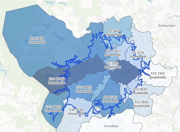
| On the map | |
|---|---|
| The 10-minute drive | |
| Most homes inside it | |
| Fewer homes inside it |
The same list, district by district, downloads as a spreadsheet for your distributor.
For any local business with a door‑to‑door drop
A new café, a takeaway, a gym, a dental practice.The first customers live nearby.
The question is which postcodes, and how many leaflets.
The area you can reach in ten minutes by road is a drive-time catchment; mapping people call it an isochrone. It follows the roads, not a circle.
A leaflet distributor wants postcodes and a count. So the answer comes by postcode district, the first half of a postcode, with the households in each.
One real shop
A new shop, a 10-minute drive, every home in reach
A new shop opening in January in Sheffield, given by its postcode with no file attached. Mapstack found the postcode district boundaries and the census households itself.
- Homes in reach
- 124,406households within a 10-minute drive of the shop
- Districts
- 16postcode districts the drive reaches into
- Most
- S2the district with the most homes inside the drive
| District | In the drive | Whole district |
|---|---|---|
| S2 | 18,444 | 18,554 |
| S10 | 17,056 | 17,347 |
| S8 | 15,762 | 20,462 |
| S6 | 15,430 | 26,650 |
| S11 | 14,015 | 14,061 |
| S3 | 7,192 | 7,266 |
| S7 | 6,649 | 6,654 |
| S5 | 5,427 | 25,611 |
Each district comes with both counts.
The homes inside the drive sit beside the whole district, so you can see which districts the drive takes in nearly whole and which only in part. The eight with the most homes are drawn here; the spreadsheet has all 16.
Households: Office for National Statistics, Census 2021, by output area, shared out across the drive area and the districts. Postcode district boundaries: open data, found by Mapstack. Drive time along the road network, without live traffic. Run on 15 November 2026.
How it goes
You bring the postcode and the drive time. Mapstack brings the roads, the boundaries and the census.
Give the postcode and how far to go.
Mapstack draws the drive and shades every district.
You get the spreadsheet.
The drive area is where it starts
Mapstack offered these next.
Closest first
To prioritise the print run.
- Split the drive area into a 5-minute zone and a 5 to 10-minute zone.
On paper
For the distributor.
- Make an A4 printable sheet of the map, with a title, legend and scale bar, as a PDF.
Written up
For the launch plan.
- Write a leaflet plan report.
Common questions
What happens to our shop details?
It stays in your workspace. Only people with a seat in your workspace can see it. Nothing leaves unless you publish it yourself.
It is not used to train AI. Your data and your conversations are not used to train AI models.
It is still yours. You keep ownership of what you bring in. Delete it and it is removed.
The full answer is in the documentation: Your data, privacy and security.
What does it cost?
Free to start. One seat, for you, with a starter amount of work each month. No card.
The drive area, the counts, the spreadsheet and the map are on the free seat. With your own files and public sharing.
A printable sheet or a written report is on a paid seat. Paid seats are per person, and bring more work each month.
The prices are on the pricing page.
How are the homes counted?
From the census. Census 2021 households, fetched for you area by area.
Shared out at the edges. Where a census area crosses the drive’s line or a district edge, its households are shared out between them.
Along the roads. The drive is measured on the road network, without live traffic.
Plan your drop.
Free to start. Prints and reports on a paid seat.