
Choropleth map from official statistics
Map an official statistic, area by area.
Name the measure and the place. You get a thematic map with each area shaded by its value, and the source and year stated.
Free to start. No card.
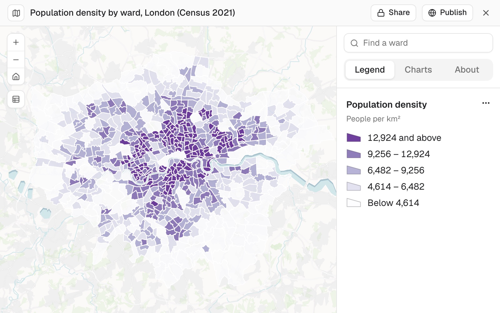
| People per km² | Wards |
|---|---|
| 12,924 and above | 136 |
| 9,256 to 12,924 | 136 |
| 6,482 to 9,256 | 136 |
| 4,614 to 6,482 | 136 |
| Below 4,614 | 136 |
680 wards in five quantile classes of 136 each. The dense inner ring stands out.
For whoever writes the briefing
A funding bid.A needs assessment.A paper for the board.
Each one needs a map that shows where, with a source nobody can argue with.
Usually that means finding the table, finding the boundaries, joining the two, and fighting a mapping program over the colours.
This starts from the question. Mapstack fetches the figures and the areas itself, and tells you which release and table they came from.
One real map
680 wards, one census table, the ten densest named
Population density from the Office for National Statistics' Census 2021, for every ward in London, for a briefing on where demand for local services is most concentrated.
- The areas
- 680areas in London's 2022 ward set, each with its official code
- The classes
- 136wards in each of five classes, by quantile
- The densest
- 26,449people per square kilometre in Church Street, Westminster
| Ward or class | People per km² |
|---|---|
| Church Street, Westminster: the densest | 26,449 |
| Cazenove, Hackney: tenth densest | 20,677 |
| Where the top class starts | 12,924 |
| Where the bottom class ends | 4,614 |
A briefing needs numbers as well as a map.
Ask for the areas you want to name, with the figure behind each. Here the ten densest wards run from 26,449 people per square kilometre down to 20,677, and four of the ten are in Westminster.
Office for National Statistics, Census 2021, table TS006 Population density, for the 2022 wards. Run on 11 November 2026.
Check the source before it goes in the briefing
Before a map goes in front of anyone, confirm what the figures are. Ask.
Compare the release with the publisher's own site.
State the year on the map if it matters to your readers.
Which census and table do these figures come from, and which set of ward boundaries are they for?
Census 2021, table TS006 Population density, for the 2022 wards.
How it goes
You name the measure and the place. Mapstack does the fetching, the joining and the shading.
Name the measure and the place.
Mapstack fetches the figures and the areas and makes the map.
You set the classes and colours, and pull out the figures for the text.
The step-by-step guide is in the documentation: Map an official statistic area by area.
One statistic is where it starts
The same request stretches further. Each of these is something you can ask for today.
Style it for the document
Say exactly how the values are grouped and shaded.
- 5 classes by quantile, in a single purple from light to dark.
- Use natural breaks instead.
- Put the source in the map's About panel.
Pull out the figures
The numbers the text will quote.
- List the ten wards with the highest density, with the borough and the figure for each.
Other measures
Any published figure, as a rate.
- Map it as a share of all households, not a count.
- Do the same for another measure from the census.
Common questions
What does it cost?
Free to start. One seat, for you, with a starter amount of work each month. No card.
This job is on the free seat. Maps, datasets, analysis, your own files and public sharing are all included.
Pay per person for more. A paid seat brings more work each month, and seats for your team.
The prices are on the pricing page.
Where do the figures come from?
Published statistics. Census and official figures, fetched for you with the areas they belong to.
Named. Mapstack tells you the release, the table and the set of boundaries.
Mapped as a rate. A count is divided by the right total, so big areas do not win by size.
Classes you choose. Quantiles, natural breaks or equal intervals, with areas that have no value in a class of their own.
Make yours.
Free to start. No card.