
A walking trail map for a self-guided tour
Put your trail on a map visitors can follow.
Attach your list of stops. You get a map visitors follow on their phone, with numbered stops in walking order and a story and photo at each.
Free to start. Reports and prints on a paid seat.
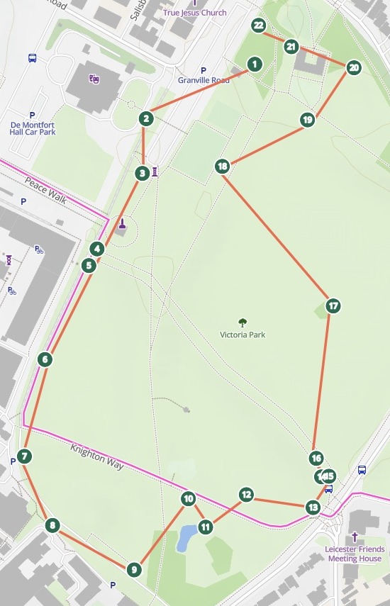
| On the map | |
|---|---|
| Trees, each a numbered stop | 22 |
| The line, in stop order | 1 to 22 |
From an English Oak at stop 1 to a Yew at stop 22. Tap a stop for its story and the council's photo.
For whoever looks after a trail
Tree trails.Heritage walks.Sculpture trails.Town tours.The stops are in a spreadsheet.
Visitors need them on the path, in order, in their hand.
A self-guided tour asks three things of a map: where each stop is, which way to walk next, and what to read on arrival.
Here you attach the list you keep. Mapstack places the stops, joins them in order and writes each stop its own pop-up.
From the trail list to the trail map
Columns: Tree number (the number on its tag), Common name (what visitors call it), Tree information (a short story), Photograph (a link to its photo). 22 rows. Each with its latitude and longitude. Leicester City Council's own open data, under the Open Government Licence.
What you get
- Every tree on its own spot, at the coordinates in the file.
- A line from stop to stop, straight between them, so visitors can see which way to go next.
- Its story at every stop: tap a tree for its number, name, story and photo.
- A search by number or name: type "1" or "Oak" to find a tree.
How it goes
You bring the list of stops. Mapstack makes the trail.
Attach the list and say what a visitor should see.
Mapstack draws the trail across the ground.
You publish one link for the trail board.
Go further
The same trail, tuned for the phone and taken onto paper.
On the phone
Change how the trail looks in the hand.
- Make the walking line thicker so it stands out on a phone screen.
- Change the basemap so the park’s paths show more clearly.
For the gate
Something to hold beside the QR code.
- Create a printable trail map for the board at the park entrance.
- Print a trail leaflet visitors can pick up as they arrive.
For the visitor
The stories, gathered in one place.
- Write a visitor guide report with every stop and its story.
Common questions
What happens to our trail list?
It stays in your workspace. Only people with a seat in your workspace can see it. Nothing leaves unless you publish it yourself.
It is not used to train AI. Your data and your conversations are not used to train AI models.
It is still yours. You keep ownership of what you bring in. Delete it and it is removed.
The full answer is in the documentation: Your data, privacy and security.
What does it cost?
Free to start. One seat, for you, with a starter amount of work each month. No card.
The trail map and its public link are on the free seat. With your own files and public sharing.
A printed map or a visitor guide is on a paid seat. Paid seats are per person, and bring more work each month.
The prices are on the pricing page.
How do visitors open it?
You publish it. Select Publish at the top of the map, then Public.
Nobody signs in. Anyone with the link opens the trail on their phone.
One link, one QR code. Copy the link into your QR code maker for the trail board.
Map your trail.
Free to start. Reports and prints on a paid seat.