
Outdoor wayfinding maps
Make the map for your park’s information boards.
Attach the list of places in your park. You get an A3 board map with a symbol for each kind of place and a "You are here".
Free to start. Print-ready sheets on a paid seat.
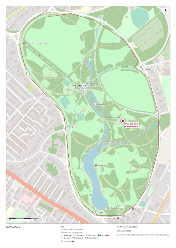
| On the board | |
|---|---|
| You are here | Palm House |
| Places to visit | Statues and the lake |
| Cafés and food | Each by name |
| Car parks | Marked P |
Laid out from one list of places, for the sign maker to enlarge.
For whoever puts up the boards
Parks, campuses, hospital sites, business parks.
A board on site has one job: show a stranger where they are, and where everything else is.
Signs and maps that help people find their way are called wayfinding. The park map on the board is at the heart of it.
Here you bring the list of places. Mapstack lays out the sheet for your sign maker.
From a list of places to the board
Columns: Category (the kind of place), Name (what the board calls it), Latitude (where it is), Longitude (where it is). 18 rows. Here, a list exported from OpenStreetMap beforehand and trimmed to the park. A spreadsheet of your own, with a name, a kind and a position for each place, does the same job.
What you get
- An A3 portrait sheet with your title, a key, a north arrow and a scale bar.
- Every place by name, beside its own symbol.
- A "You are here" marker on the place you name, with its own line in the key.
- The park beneath: its paths, lawns, woods and water from the base map.
One real board
Sefton Park, Liverpool, for the board outside the Palm House
One message with the park’s list of places attached, and the A3 sheet came back in the same turn.
- Scale
- 1:4,000at A3, stated on the sheet beside the scale bar
- In the key
- 7kinds of place, each with its own symbol, besides You are here
- Labelled
- 18places, each once, under the name in your list
- You are here, the Palm House
- 1
- Places to visit
- 4
- Car parks
- 4
- Cafés and food
- 3
- Gates
- 3
- Bandstand
- 1
- Playground
- 1
- Public toilets
- 1
The names on the board are yours.
Mapstack turned off the base map’s labels "to keep the map clean and prevent duplicates", so the Boathouse Kiosk, the Peter Pan Statue and the Bandstand each appear once, as your list names them.
Places: OpenStreetMap contributors (ODbL), exported for the park on 15 November 2026 and attached as one file. Base map: OpenStreetMap. Run on 15 November 2026.
How it goes
You bring the list. Mapstack lays out the board.
Attach the list of places and say where the board stands.
Mapstack lays out the sheet with your places over the park.
You send it to the sign maker.
Common questions
What happens to our list of places?
It stays in your workspace. Only people with a seat in your workspace can see it. Nothing leaves unless you publish it yourself.
It is not used to train AI. Your data and your conversations are not used to train AI models.
It is still yours. You keep ownership of what you bring in. Delete it and it is removed.
The full answer is in the documentation: Your data, privacy and security.
What does it cost?
Free to start. One seat, for you, with a starter amount of work each month. No card.
The map of your places is on the free seat. With your own files and public sharing.
The print-ready board sheet is on a paid seat. Paid seats are per person, and bring more work each month.
The prices are on the pricing page.
Can we change it before print?
Labels, symbols and framing. Ask for a change in your own words before the file goes to the sign maker.
Your list stays as it was. It becomes its own dataset, and the sheet is drawn from it.
Make your board map.
Free to start. Print-ready sheets on a paid seat.