
School catchment and walking distance
Check who is in the school catchment.
Give Mapstack the addresses and the catchment (the attendance zone). You get each address marked in or out, its walk to school measured, and those over your threshold flagged.
Free to start. No card.
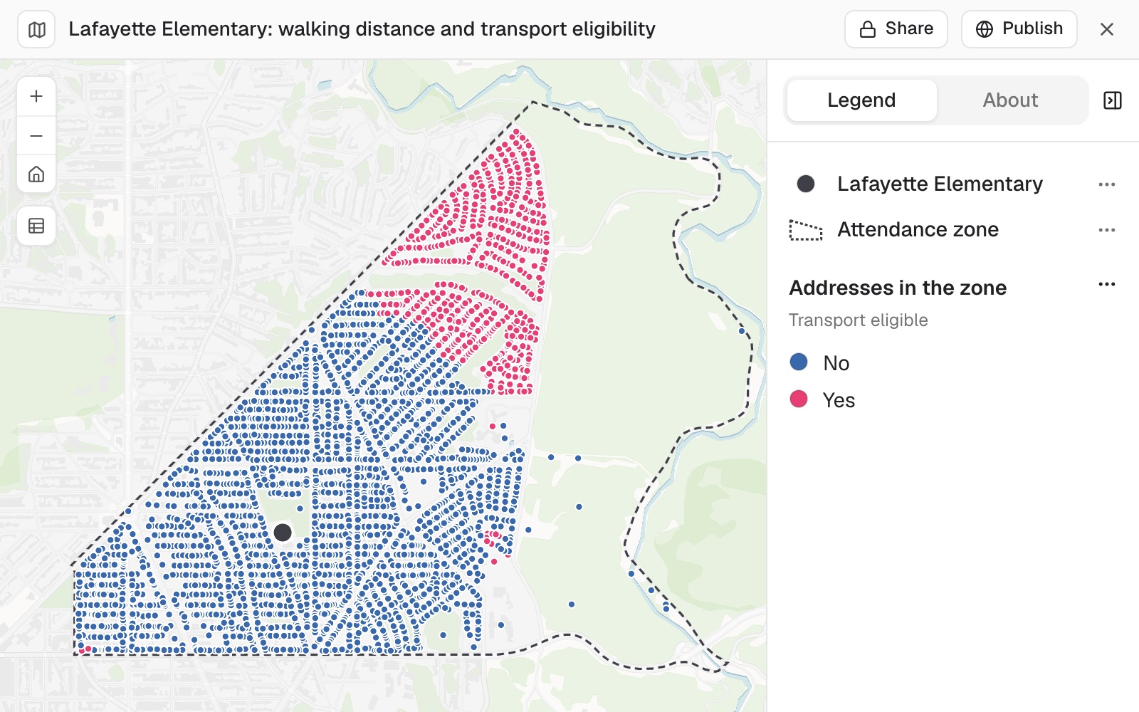
| Residential addresses | Homes |
|---|---|
| Over a mile's walk | 639 |
| Within a mile | 2,936 |
Measured in a straight line, only 301 of the 639 would have qualified.
For whoever answers the parents
Are we in the catchment?Does my child qualify for the bus?
Every answer can be appealed, so every answer needs a distance and a method.
The usual way is a straight line on a map, which is shorter than any walk a child can take.
This measures the walk along streets and paths for every address at once, and draws the route for the ones that are challenged.
One real zone
3,575 homes, a one-mile threshold, 639 over it
Every address in a real attendance zone, from a city's public address register, with the zone's boundary. Pupil addresses are personal data and were not used.
- The homes
- 3,575residential addresses in the zone
- The threshold
- 1 mileof walking, the authority's rule for transport
- Over it
- 639homes that qualify, measured along streets and paths
| How the distance is measured | Homes over a mile |
|---|---|
| Along streets and paths | 639 |
| In a straight line | 301 |
A walk is longer than a straight line.
Measuring as the crow flies would leave out about half of those who qualify. The walks here run from 0.04 to 1.90 miles, 0.70 on average.
Addresses: DC Master Address Repository. Zone: DC school attendance zones, in force from 2025–26. Both from the District of Columbia's open data. Run on 11 November 2026.
Draw the route for a case under appeal
Name the address and say it is for an appeal.
Ask for the method by its parts, and Mapstack writes it up for the appeal record.
For 3300 Rittenhouse Street NW, show me the walking route to the school and the distance, for an appeal.
0.33 miles, about 7 minutes. Inside the zone, not eligible. The route is added to the map as a line from the address to the school.
How it goes
You bring the addresses and the boundary, and state the threshold. Mapstack does the measuring.
Attach the addresses and the catchment, and state your threshold.
Mapstack measures every walk along streets and paths.
You get every address with its answer.
The step-by-step guide is in the documentation: Check which addresses are in a school catchment and how far each is to walk.
Common questions
What happens to our address data?
It stays in your workspace. Only people with a seat in your workspace can see it. Nothing leaves unless you publish it yourself.
It is not used to train AI. Your data and your conversations are not used to train AI models.
It is still yours. You keep ownership of what you bring in. Delete it and it is removed.
The full answer is in the documentation: Your data, privacy and security.
What does it cost?
Free to start. One seat, for you, with a starter amount of work each month. No card.
This job is on the free seat. Maps, datasets, analysis, your own files and public sharing are all included.
Pay per person for more. A paid seat brings more work each month, and seats for your team.
The prices are on the pricing page.
How is the distance measured?
Along streets and paths. The walk a person can take, not a straight line.
From each address to the school. Every address gets its distance, its time and its flag.
It asks first. Before measuring thousands of walks, it shows what the job will use and waits for your go-ahead.
Written down. Where it measured from and to, the network and the date of the data, for the record.
Check yours.
Free to start. No card.