

Check which addresses are in a school catchment and how far each is to walk
Check each address against a school catchment, measure the walk to the school along streets and paths, and flag those over your transport threshold.
Best for
Admissions and transport officers at a school district or council, and anyone who has to answer "are we in the catchment?" or "does my child qualify for the bus?". You end up with every address marked in or out of the catchment (the attendance zone), its walking distance and time to the school, a flag against your threshold, a map, a drawn route for any case under appeal, and a written method.
The example in this guide uses two public files from the District of Columbia's open data. Pupil and applicant addresses are personal data and never public, so it takes every address in a real attendance zone instead, which is what an authority checks when it sets or reviews a walking threshold. The first file is 3,664 address points from the DC Master Address Repository, every one inside the Lafayette Elementary School zone: 3,575 residential and 89 not, each with its address, type, number of housing units, ZIP code, ward, latitude and longitude. The second is the Lafayette Elementary attendance zone boundary from DC's school attendance zones, the boundaries in force from the 2025–26 school year. The school is at 5701 Broad Branch Road NW.
What you need
- The addresses, as a spreadsheet with latitude and longitude, or with a full address on each row for Mapstack to look up.
- The catchment boundary, as a GIS file (GeoJSON, shapefile, GeoPackage, KML) or a boundary Mapstack can fetch.
- The school's address, or the point your policy measures to.
- Your threshold, in miles or kilometres, and whether it applies to every address or only residential ones.
- A Free, Creator or Creator Max seat.
Before you start
- Personal data. Applicant addresses are personal data. Keep the session and its datasets private, and do not publish the map.
- Routing uses part of your allowance. Measuring a walk for thousands of addresses is a large job. Mapstack shows a card with roughly what share of your allowance it will use and waits for Go ahead.
- Walking routes follow OpenStreetMap. Streets, pavements and paths that are open to walkers count; a path missing from the map is not used.
The prompt
Attached are the addresses in our area and the Lafayette Elementary attendance zone. For each address, is it inside the zone, and what's the walking distance along streets and paths to the school at 5701 Broad Branch Road NW? Flag every residential address more than 1 mile's walk away, which is our threshold for transport.
What to expect
Mapstack turns both files into datasets
The addresses become a dataset of points, placed from their latitude and longitude, and the zone becomes a dataset of one boundary. Both stay in your session to open and check.
It asks before routing every address
Before measuring thousands of walks, Mapstack shows a card with roughly what share of your allowance the routing will use. It also offered two cheaper ways: straight-line distance, or checking only the addresses outside the zone. Select Go ahead for walking distances along the network, which is what a transport policy measures.
You get every address with its answer
A new dataset holds every address with four new columns: inside the zone or not, walking distance in miles, walking time in minutes, and transport eligible (true for residential addresses over the threshold). The reply gives the totals.
In the example all 3,664 addresses are inside the zone, as expected for a file cut to it. Of the 3,575 residential addresses, 639 are more than a mile's walk away and 2,936 within it. Their walks run from 0.04 to 1.90 miles, 0.70 on average.
A walk is longer than a straight line. Only 301 of the same addresses are more than a mile from the school as the crow flies, so measuring in a straight line would leave out about half of those who qualify.
You see who qualifies on a map
How many residential addresses qualify, and show them on a map with the zone and the school.
Mapstack placed the school from its address and made a map: the zone outline, the school, and every address coloured by whether it qualifies, with the distance, walking time and type in each pop-up, and a chart and table to filter by.
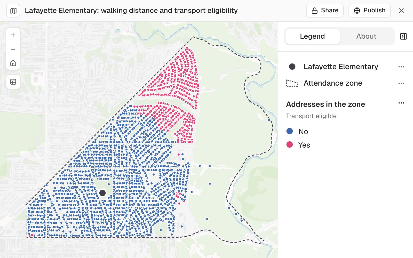 Example: the Lafayette Elementary zone. Pink addresses qualify: homes more than a mile's walk from the school. Blue ones do not.
In the example the qualifying addresses sit together in the north of the zone, the part farthest from the school.
You draw the route for a case under appeal
Name the address and say it is for an appeal. The route is added to the map as a line from the address to the school, with the distance and time in its pop-up. For 3300 Rittenhouse Street NW, in the example: 0.33 miles (0.54 km), about 7 minutes, inside the zone, not eligible.
You write down the method
Ask for the method by its parts: where the distance is measured from and to, the network, and the date of the data. Mapstack writes it up for the appeal record: from each address point in the address file to the school's location at its address; along the OpenStreetMap network of streets, pavements and paths open to walkers; eligible when the walk is more than 1.00 mile; the network as of the day of the run. Where the address file carries no release date, it says so, and suggests citing the address register's release and the school year of the boundary alongside the measurement.
Check the method against your published policy before you rely on it. If your policy measures to a particular gate or from the edge of the property, that is a different point from the one used here; say where it is.
Make it your own
List the residential addresses within a tenth of a mile of the threshold either side, so we can check them by hand.
For 3300 Rittenhouse Street NW, show me the walking route to the school and the distance, for an appeal.
Write down the method: where the distance is measured from and to, the network used, and the date of the data.
Common questions
Can I use straight-line distance instead?
Yes, and Mapstack offers it, but a walk is longer than a straight line. In the example 301 residential addresses are over a mile from the school as the crow flies, against 639 by walking: a straight line would leave out about half of those who qualify.
How do I check who qualifies?
Check the threshold and the rule (over or at the distance, residential only or all), then ask for the addresses close to the line and look at their routes. In the example 352 residential addresses are within a tenth of a mile of it, so a small change in where distances are measured from moves a lot of families.
Can I measure to the school gate?
Yes. Give the point your policy measures to, with its latitude and longitude. Otherwise Mapstack places the school from its address; look at where it sits on the map before you rely on the distances.
Why does a route go the long way round?
The path it should use is missing from OpenStreetMap, or not open to walkers there. Measure that case by hand, and add the path to OpenStreetMap if it is public.
What about addresses right on the zone boundary?
A point on or close to the line can fall either side, and a boundary from another year gives different answers. Check the address point, and which version of the boundary you attached.