
Nearest facility and proximity analysis
Find what is nearest each of your sites, by road.
Attach the places to be near and name the sites to measure from. You get the nearest place to each site by road, the distance, and a map.
Free to start. Printable maps on a paid seat.
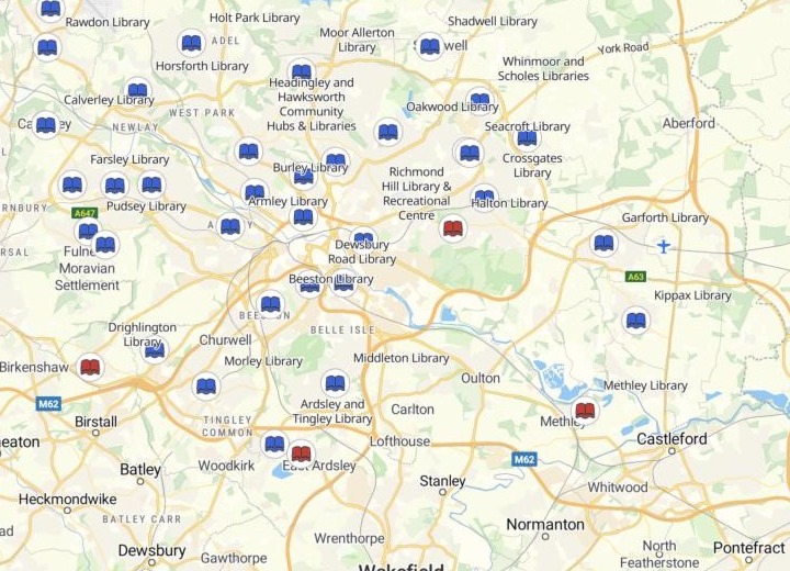
| Libraries, by the road distance to the nearest primary school | |
|---|---|
| Over 1 km | |
| Within 1 km |
Select any library for its nearest school, the road distance and an estimated drive time.
For anyone asking what is nearest
A library and the nearest school.A depot and the nearest customer.A clinic and the nearest bus stop.
The answer is a distance along the roads, not across the map.
Mapping people call this a nearest-facility or proximity analysis. A straight line crosses rivers, railways and ring roads. The road distance goes round them.
Attach the list you trust, name the sites to measure from, and set a limit. The sites beyond it come back by name, furthest first.
One real city
Every library in Leeds, and its nearest primary school
The Department for Education's register of open primary schools in Leeds, attached with each school's grid reference (its easting and northing). Mapstack found the city's public libraries itself, then routed from each one along the roads.
- Attached
- 221open primary schools, every one placed on the map
- Found
- 41public libraries inside the city boundary, each with its nearest school by name
- Beyond 1 km
- 4libraries with no primary school within 1 km along the roads
| Library | By road | Nearest primary school |
|---|---|---|
| Drighlington | 2.93 km | Birchfield Primary School |
| Ardsley and Tingley | 1.26 km | Blackgates Primary Academy |
| Halton | 1.25 km | Corpus Christi Catholic Primary School |
| Methley | 1.19 km | Methley Primary School |
| Seacroft and Crossgates | 976 m | Our Lady of Good Counsel Catholic Primary School |
The line falls where you put it.
Methley Library is the nearest miss. The Seacroft and Crossgates hub is the last library inside the line, and is drawn in blue.
Department for Education, Get Information About Schools: open primary schools in Leeds, 14 November 2026, Open Government Licence v3.0. Public libraries found by Mapstack. Distances by road. Run on 14 November 2026.
How it goes
You bring the list and name the sites and the limit. Mapstack finds the sites and does the routing.
Attach your list and name your sites.
Mapstack routes from each one and maps the result.
You get the nearest of each, by name.
Take it further
Each of these is a request you can send today.
Both sides your own
Attach two lists, and name which way to look.
- Here are our community centres and the city’s libraries. For each centre, find the nearest library by road.
On foot
The next question is often who can walk there.
- Draw a 10-minute walk around each library.
Hand it on
For the next planning meeting.
- Make the full list of libraries and their nearest schools a dataset I can download.
- Make a printable map of the libraries with no primary school within 1 km.
Common questions
What happens to our lists?
It stays in your workspace. Only people with a seat in your workspace can see it. Nothing leaves unless you publish it yourself.
It is not used to train AI. Your data and your conversations are not used to train AI models.
It is still yours. You keep ownership of what you bring in. Delete it and it is removed.
The full answer is in the documentation: Your data, privacy and security.
What does it cost?
Free to start. One seat, for you, with a starter amount of work each month. No card.
The nearest-by-road list and the map are on the free seat. With your own files and public sharing.
A printable map is on a paid seat. Paid seats are per person, and bring more work each month.
The prices are on the pricing page.
How is nearest measured?
By road. Along the road network, not as the crow flies.
One answer for every site. Its nearest by name, with that place’s address and type, and the distance in metres.
Your list, or found for you. Attach the list you trust. Name what you do not have, and Mapstack finds it.
Find yours.
Free to start. Printable maps on a paid seat.