
Legal restrictions on a land register
Put every restriction on your land register.
Attach your land register and the layers that restrict it. You get every parcel with its rights of way, greens, commons and tree orders, counted and ranked.
Free to start. Print-ready plans on a paid seat.
| On the plan | |
|---|---|
| Council land | 4 parcels |
| Public footpaths | By route code |
| Registered village green | VG/5 |
| Tree preservation order zones | Beside it |
| Scale at A3 | 1:10,000 |
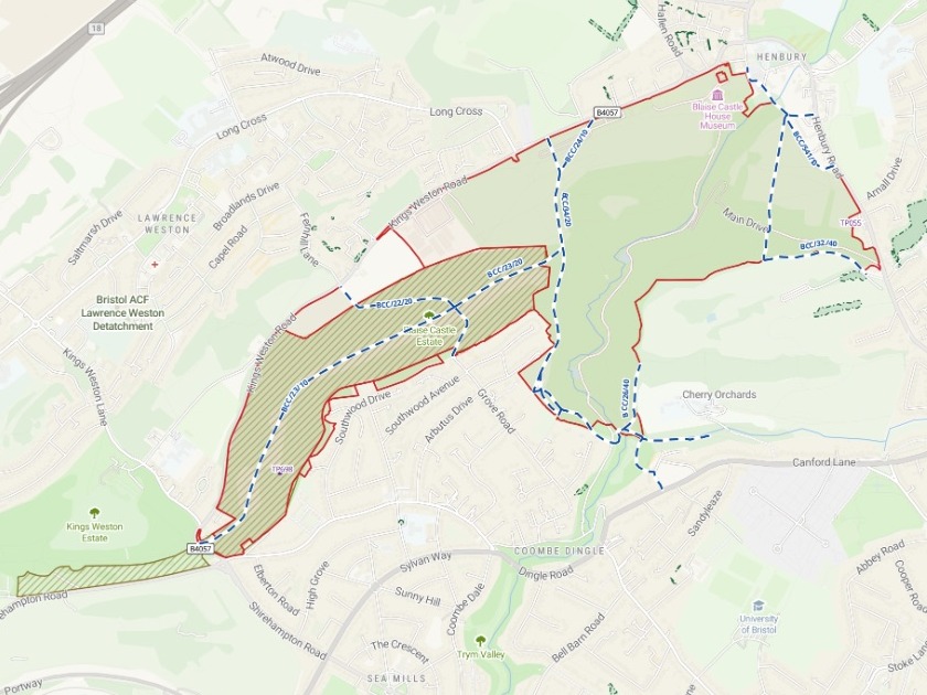
One estate from the register: its paths by route code, the village green across the western parcel, the tree order zones beside it.
For whoever keeps the land terrier
Parks, playing fields, farms, allotments, commons.
Before any of it is sold, leased or fenced, someone has to say what already binds it.
A land terrier is the register of the land an organisation owns. A public right of way is a path anyone may use by law. A tree preservation order, or TPO, protects a tree, a group or a wood. Each can bear on a sale, a lease, a new fence or a building.
Here you bring the register and the layers. Mapstack lays one over the other, writes what it finds onto each parcel, and draws the plan.
One real register
A city's open land, checked against four legal layers
Bristol City Council's record of the open land it owns, from parks and playing fields to farms and cemeteries, against the council's own open data on rights of way, commons and greens, and tree orders. Five files, one message.
- At least one
- 349parcels carry a right of way, a common or green, or a tree order
- Most path
- 5.54 kmof public rights of way inside Stoke Park Estate, across 25 route codes
- Ranked
- 10parcels with the most path inside, each with its route codes
| Parcels affected, by kind of restriction | Parcels |
|---|---|
| Crossed by a public right of way | 234 |
| Touching a common or village green | 73 |
| With protected trees standing on them | 71 |
| Under a tree preservation order zone | 55 |
Every parcel keeps what it had, and gains the rest.
The route codes and the metres of path inside it, the name and reference of any common or green, the TPO order numbers, a count of protected trees, and a yes or no for any restriction at all.
Bristol City Council open data: council property ownership, kept to 13 kinds of open land; public rights of way; common land and village greens; tree preservation zones; and the TPO tree dataset. Downloaded and attached on 15 November 2026, and run the same day.
Ask for a plan of one estate
One more sentence gives the land terrier file its plan.
Its reply added that conveyancing should go by the definitive map and the statutory registers.
Make an A3 landscape plan of the Blaise Castle Estate for the land terrier file: our land there, every public right of way on it shown by type and labelled with its route code, and any village green, common land, TPO zones and TPO trees that touch it, with a legend, scale bar and north arrow.
An A3 landscape plan of the estate: the council's parcels in red, the public footpaths dashed in blue with route codes such as BCC/34/10 and BCC/541/10 along them, the registered village green hatched across the western parcel, and the protected trees by order number.
How it goes
You bring the register and the layers. Mapstack does the overlay and the counting.
Attach the register and the layers in one message.
You get every parcel’s restrictions, ranked by how much path runs through it.
Ask for the plan of any one estate, at A3.
Common questions
What happens to our register?
It stays in your workspace. Only people with a seat in your workspace can see it. Nothing leaves unless you publish it yourself.
It is not used to train AI. Your data and your conversations are not used to train AI models.
It is still yours. You keep ownership of what you bring in. Delete it and it is removed.
The full answer is in the documentation: Your data, privacy and security.
What does it cost?
Free to start. One seat, for you, with a starter amount of work each month. No card.
The register and the map are on the free seat. With your own files and public sharing.
The A3 plan as a PDF or picture is on a paid seat. Paid seats are per person, and bring more work each month.
The prices are on the pricing page.
Where do the layers come from?
Your council’s open data. Rights of way, commons and greens, and tree orders, as files you attach.
Or a link to each. Paste the link to a dataset’s page on an open-data portal, and Mapstack finds the download behind it.
Check your land.
Free to start. Print-ready plans on a paid seat.