
Route corridor checks
List everything your route crosses, in order.
Attach a proposed route and an export of what lies around it. You get the crossings schedule: every crossing in order, with its grid reference and chainage.
Free to start. Reports and prints on a paid seat.
| Crossings by type | Crossings |
|---|---|
| Road | 8 |
| Railway | 4 |
| Waterway | 2 |
| Pipeline | 2 |
| Motorway | 1 |
Each crossing is numbered from the Appley Bridge end.
For whoever takes a route into design
A cycle route, a pipeline, a cable, a new road.
Before the design goes far, someone has to list everything it crosses, and who owns each one.
Every crossing is a conversation: with the railway, the highways authority, the river and canal authorities, the utilities and the landowners. Each will ask where it is, and how the route gets across.
Here you attach the route and an export of what lies around it. Mapstack finds the crossings and does the measuring.
One real route
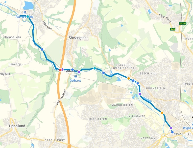
Seventeen crossings in 7.6 km, and none counted twice
One of Wigan's confirmed Bee Network walking and cycling routes, from Appley Bridge to the edge of the town centre, from Transport for Greater Manchester's open data, with an OpenStreetMap export of everything around it.
- Counted once
- M6both decks of the Gathurst Viaduct, and each pair of tracks
- Left out
- Towpaththe route runs beside the Leeds and Liverpool Canal, and alongside is not a crossing
- Crossings
- 17down to tracks and a stream; ten have no name in the data, so the chart shows the seven that do
| The named crossings, in order | From the start |
|---|---|
| M6, Gathurst Viaduct | 2,563 m |
| Manchester to Southport Line | 2,629 m |
| B5206, Gathurst Lane | 2,974 m |
| Scot Lane | 5,432 m |
| Manchester to Southport Line, again | 5,806 m |
| Wigan and Kirkby Line | 7,429 m |
| A577, Wallgate | 7,572 m |
It says how the route gets across, as far as the data shows.
The first crossing is a stream, which passes through a culvert under the route.
Transport for Greater Manchester, GM Bee Network Routes: one confirmed Beeway in Wigan. OpenStreetMap contributors: roads, railways, waterways, pipelines and power lines within 250 metres of it, as of 15 November 2026. Run on 15 November 2026.
Mark the lines no longer in use
Ask about one crossing by its number. The rest stays as it was.
The map and the download carry the same crossings as the schedule.
Crossing 7 is an abandoned railway in the OpenStreetMap data, so mark it as an abandoned railway line. Keep every crossing and distance exactly as it is, and give me the schedule as a dataset to download.
Crossing 7 became an abandoned railway line, and the railways now read three active crossings and one abandoned. Every other row and distance stayed as it was, and the schedule came back as a dataset to download as CSV, GeoPackage or GeoJSON.
How it goes
You bring the route and what lies around it. Mapstack finds and measures the crossings.
Attach the route and the export around it.
Mapstack finds each crossing and colours it by type.
You get the count by type, and who to approach.
Then take it to the owners
Each is something you can ask for today.
A print for the meeting
The route and its crossings, on paper.
- Make a print of the route and its crossings for our meeting with the railway.
A written schedule
For the design file.
- Write a technical report: the crossings schedule, the count by type and who to approach for each.
A link to send
The same map, for anyone outside the team.
- Publish the map so the owners we approach can open it from a link.
Common questions
What happens to our route?
It stays in your workspace. Only people with a seat in your workspace can see it. Nothing leaves unless you publish it yourself.
It is not used to train AI. Your data and your conversations are not used to train AI models.
It is still yours. You keep ownership of what you bring in. Delete it and it is removed.
The full answer is in the documentation: Your data, privacy and security.
What does it cost?
Free to start. One seat, for you, with a starter amount of work each month. No card.
The schedule, the map and the download are on the free seat. With your own files and public sharing.
A print or a written report is on a paid seat. Paid seats are per person, and bring more work each month.
The prices are on the pricing page.
What is on each row?
What it crosses. Its type, its name, and its road or line number where the data has one.
Where it is. The grid easting and northing, and the distance along the route from its start.
How the route gets across. Under a bridge, over a culvert, as far as the data shows.
Check your route.
Free to start. Reports and prints on a paid seat.