
Right-of-way and land acquisition tracking
See where every parcel’s deal stands, on one map.
Attach your parcel list with each parcel’s stage. You get every parcel coloured by deal stage on one shared map, and the parcels and acres counted at each stage.
Free to start. Team seats, reports and prints are paid.
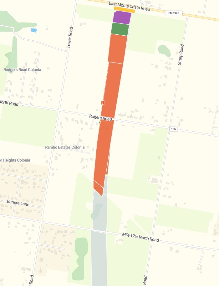
| Each parcel, by deal stage | |
|---|---|
| Created | Not started |
| Appraisal approved | Ready for offer |
| Final offer | Late-stage negotiation |
| Acquired by deed | Signed and closed |
| Special commissioner phase | Condemnation |
The whole project on one shared map. Shown here: its north end, close up, with a condemnation parcel at the top.
For whoever is buying the land
Right-of-way agents.Land and site acquisition teams.
Every parcel is a deal somewhere between appraisal and a signed deed, and the whole team needs to see which.
Right-of-way is the land a new road or utility line needs, bought parcel by parcel. A parcel whose owner will not agree goes to condemnation. Keeping one record of where each parcel stands is acquisition tracking.
Here you attach the parcel list. Mapstack draws every parcel in the colour of its stage and does the counting.
One real acquisition project
Where 169 parcels stand, from appraisal to deed
The Texas Department of Transportation’s open data on right-of-way parcels, kept to one project in Hidalgo County: each parcel of land the road needs, drawn on the ground with its stage, property type and acres. Mapstack used the file and fetched nothing.
- Still open
- 929acres across 109 parcels not yet signed
- Signed
- 154.8acres acquired by deed, across 60 parcels
- In condemnation
- 2parcels in the special commissioner phase, stood out on the map
- Created, not started
- 13
- Appraisal reviewed
- 1
- Appraisal approved
- 13
- Initial offer
- 28
- Final offer
- 52
- Special commissioner phase (condemnation)
- 2
- Acquired by deed
- 60
Acres at every stage, and every open offer ranked.
Each open offer comes with its stage and its property type.
Texas Department of Transportation, ROW proposed parcels (open data), project 3629-01-004, Hidalgo County. Downloaded and attached on 15 November 2026, and run the same day.
How it goes
Attach the parcel list with each parcel’s stage.
Mapstack colours every parcel by where its deal stands.
You get the open offers, ranked by acres.
Then take it to the team
Mapstack offered these next. Each is something you can ask for today.
By property type
Which kinds of land are still open.
- Break the open parcels down by property type.
A report
For the project meeting.
- Write an acquisition report on where every parcel stands.
A print
To hand round on paper.
- Print the property map.
Common questions
What happens to our parcel list?
It stays in your workspace. Only people with a seat in your workspace can see it. Nothing leaves unless you publish it yourself.
It is not used to train AI. Your data and your conversations are not used to train AI models.
It is still yours. You keep ownership of what you bring in. Delete it and it is removed.
The full answer is in the documentation: Your data, privacy and security.
What does it cost?
Free to start. One seat, for you, with a starter amount of work each month. No card.
The map, the counts and the ranked list are on the free seat. With your own files and a public link.
Seats for your team are paid. One for each person who opens the map privately. Written reports and prints are on a paid seat too.
The prices are on the pricing page.
What is on the map?
Every parcel, by stage. In deal order, from grey for not started to green for signed, with condemnation in purple and a bold red outline.
Details on a click. The parcel ID, its stage, its property type and its acres.
Search and a table. Find a parcel by its ID, or sort every parcel in the table.
Map your parcels.
Free to start. Team seats, reports and prints are paid.