
Parcel mapping from recorded deeds
Update the parcel register from the year's deeds.
Attach your parcels and the deeds recorded since the last update. You get each sale on its parcel, the deeds to check, and a map of what sold.
Free to start. No card.
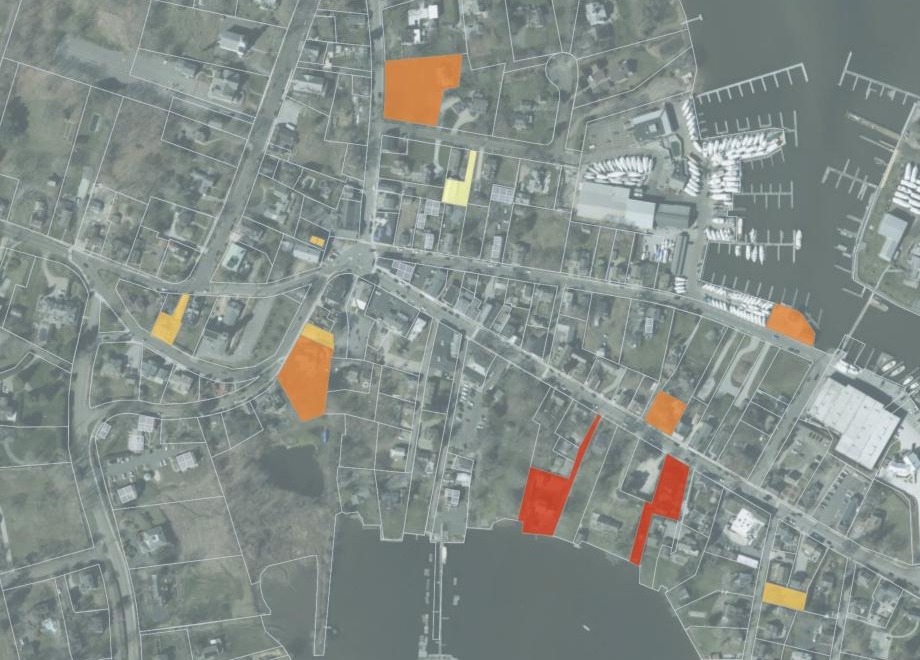
| Sale price | |
|---|---|
| $3,600,000 to $8,350,000 | |
| $1,200,000 to $3,600,000 | |
| $575,000 to $1,200,000 | |
| Below $575,000 |
Open a sold parcel for its deed date, sale price, property type and non-use code. No owners’ names.
For the assessor's office
Every deed recorded has to reach the right parcel, at the right price.
A list of recorded sales gives an address and a price, not a parcel ID. The same street runs through two villages, a condo building holds many units, and one deed can cover several lots.
Here you attach the parcels and the deeds. Mapstack matches them on your own parcel file and sets aside the deeds that may move a parcel line, for you to check against the deed and survey.
From a list of sales to a register on your own parcels
Columns: Serial number (one per deed), Date recorded (when it was filed), Address (with the village suffix), Sale price (as recorded), Property type (house, condo, land), Non-use code (why a sale is unusual). 135 rows. With it, your parcels as a zipped shapefile: parcel ID, address, acres, land use and assessed value, and no owners’ names.
What you get
- Your own parcels: the register is built on the file you attach, and Mapstack names it.
- Each sold parcel with its latest deed date, sale price, property type and non-use code.
- No owners’ names in the register or on the map.
One real town
A year of deeds on the town’s own parcels
The deeds recorded in Essex, Connecticut, from October 2024 to September 2025, and the town’s parcels from the state’s 2024 parcel layer.
- Matched
- 134 of 135deeds placed on their parcel, condo sales on the unit
- Not found
- 1deed, for an address the parcel file does not have, named with the reason
- To check
- 5deeds that may change parcel lines, as a file to download
| Deed to check | Price |
|---|---|
| Sale to an abutting owner, Centerbrook | $1,750,000 |
| Sale to an abutting owner, Pratt Street | $1,625,000 |
| A change in the property | $1,525,000 |
| Two condo units on one deed | $725,000 |
| Three vacant lots on one deed | $60,000 |
Each comes with what to check against the deed and survey.
For a sale to an abutting owner: a boundary line adjustment, a lot merger, or an assemblage with the property next door. For the two condo units: the values in the deed’s remarks, $354,000 and $401,700, against their assessments.
State of Connecticut, Office of Policy and Management: Real Estate Sales, Essex, deeds recorded October 2024 to September 2025 (public domain). Connecticut GIS Office: CAMA and Parcel Layer 2024, cut to Essex (CC0). Run on 15 November 2026.
Ask which lots a deed covers
A deed can name lots without numbers. Ask, and the answer comes with its reasons.
Ask about any deed by its serial number or address, and check the reasons against the deed itself.
The Pond Meadow Rd deed is for 3 vacant residential lots. Tell me which parcels you think it covers and why, and keep it on the list to check.
Parcels 88 3-2, 88 3-3 and 88 3-4: vacant residential lots, numbered in sequence off parent parcel 88 3, at 1.84, 1.89 and 2.18 acres, assessed at $63,600, $64,000 and $66,500. The deed went onto those three and stayed on the list.
How it goes
You bring the parcels and the deeds. Mapstack does the matching.
Attach your parcels and the deeds and say how your addresses work.
Mapstack puts each sale on its parcel and colours what sold by price.
You get the deeds to check, as a file.
Common questions
What happens to our parcel file?
It stays in your workspace. Only people with a seat in your workspace can see it. Nothing leaves unless you publish it yourself.
It is not used to train AI. Your data and your conversations are not used to train AI models.
It is still yours. You keep ownership of what you bring in. Delete it and it is removed.
The full answer is in the documentation: Your data, privacy and security.
What does it cost?
Free to start. One seat, for you, with a starter amount of work each month. No card.
This job is on the free seat. Maps, datasets, analysis, your own files and public sharing are all included.
Pay per person for more. A paid seat brings more work each month, and seats for your team.
The prices are on the pricing page.
How does a deed find its parcel?
By address. Say what your village suffixes mean, and each sale goes to the parcel in its own village.
Condo sales to the unit. A deed for two units goes onto both units, not the whole building.
The latest deed. Where a parcel sold twice in the year, it carries the later sale.
Update yours.
Free to start. No card.