
Easement encroachment check
Find every building that sits in an easement.
Attach your easements and building outlines. You get every building that crosses into an easement, listed with the area inside, and mapped.
Free to start. No card.
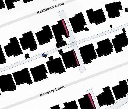
| Overlaps, by easement type | Overlaps |
|---|---|
| Drainage easement (priority) | 43 |
| Public utility easement (PUE) | 203 |
| All types | 268 |
Every overlap of 10 sq ft or more, drainage first.
For whoever keeps the easements clear
Inspectors and public works crews.
Before the work is scheduled, they need to know which buildings stand where the crew must go.
An easement is land recorded on a plat for a use such as drainage or utilities. A building that crosses into one is an encroachment: it can block the flow, and the crew.
Here you bring the easements and the building outlines. Mapstack lays one over the other and does the measuring.
From two city files to a list a crew can use
Columns: Easement type (drainage, PUE, water and more), Plat name (the plat it was recorded on), Plan ID (the plan it belongs to), File date (its filing date). 473 rows. Beside it, the building outlines from the city's 2013 survey: 2,706 of them.
What you get
- The easement type and plat for every building that crosses in.
- The square feet inside, and the share of the building that is.
- Drainage first, then the rest by type, each with a count and its total.
- A map coloured by easement type, with a pop-up for each building, a table to sort and search by plat, and the list to download as a spreadsheet.
One real subdivision
The drainage cases, largest first
Cedar Park, Texas: the city's recorded easements for the Block House Creek subdivisions and the building outlines from its 2013 survey, in one message with the request written as an inspector would put it.
- Wholly inside
- 6buildings sit entirely within a drainage easement; Mapstack read them, from their size, as sheds or outbuildings
- Water easements
- One schoolBlock House Elementary holds all four water-easement overlaps, 481.6 to 586.5 sq ft each
- Utility easements
- 479.3 sq ftthe largest overlap into a public utility easement
| Building, Block House Creek section | Inside the drainage easement | Share of the building |
|---|---|---|
| Building 104702, Sec 4 | 422.1 sq ft | 15.35% |
| Building 104589, Sec 3 | 402.9 sq ft | 16.01% |
| Building 103716, Phase E Sec 501 | 321.6 sq ft | 13.04% |
| Building 104645, Sec 4 | 283.4 sq ft | 9.96% |
| Building 104760, Sec 4 | 256.3 sq ft | 9.81% |
One table, drainage first.
Every drainage case came back with its building ID, plat, square feet inside and share of the building, ready to hand to a crew. The sheds and the school it pointed out on its own.
City of Cedar Park, Texas: Easements, and Planimetrics 2013 (building outlines, made by Aerometric), from the city's public GIS services, kept to the Block House Creek area. Downloaded and attached on 15 November 2026, and run the same day.
How it goes
You bring the easements and the outlines. Mapstack does the overlay and the arithmetic.
Attach the easements and the outlines in one message.
Mapstack measures each overlap and maps it by easement type.
You get the square feet inside, by type.
Common questions
What happens to our easement files?
It stays in your workspace. Only people with a seat in your workspace can see it. Nothing leaves unless you publish it yourself.
It is not used to train AI. Your data and your conversations are not used to train AI models.
It is still yours. You keep ownership of what you bring in. Delete it and it is removed.
The full answer is in the documentation: Your data, privacy and security.
What does it cost?
Free to start. One seat, for you, with a starter amount of work each month. No card.
This job is on the free seat. Maps, datasets, analysis, your own files and public sharing are all included.
Pay per person for more. A paid seat brings more work each month, and seats for your team.
The prices are on the pricing page.
What counts as an overlap?
Any part of a building inside an easement. Measured in square feet, and as a share of the whole building.
Every type, counted. Drainage, public utility, water and the rest, each with its count and total square feet.
Easements kept as centre lines. Say how far each reaches either side of the line, or which column holds it, and each is drawn as a strip first (a buffer).
Check yours.
Free to start. No card.