
A biodiversity net gain estimate
Work out a site's biodiversity units and carbon.
Attach the site boundary, the planned uses and a habitat map. You get biodiversity units before and after, the shortfall to 10% net gain, and the change in carbon.
Free to start. Reports and prints on a paid seat.
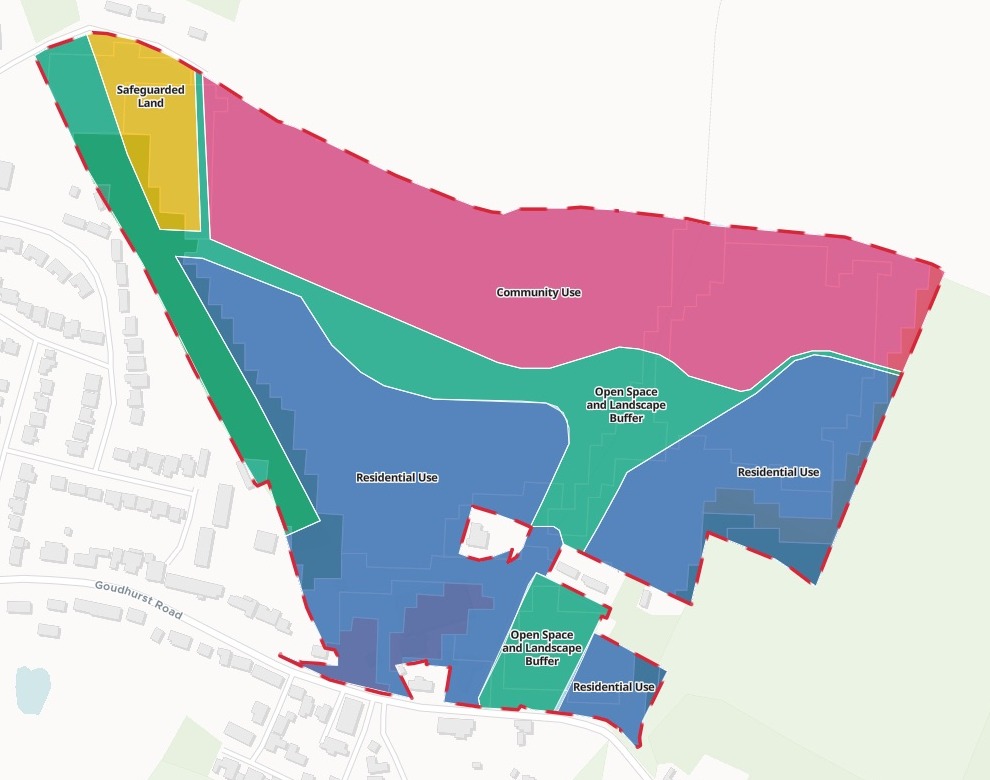
| Planned uses, as measured | Hectares |
|---|---|
| Residential use | 7.7 |
| Community use | 6.2 |
| Open space and landscape buffer | 4.2 |
| Safeguarded land | 0.8 |
| Site boundary, red dashes | 19.0 |
The darker strip down the west side is woodland, much of it inside the planned open space.
For whoever has to show the net gain
Ecologists.Planning consultants.Land promoters.
The survey is months away, and the client wants to know the biodiversity bill now.
Biodiversity net gain asks a development to leave 10% more biodiversity units than it found, counted with the statutory metric. Habitats are named in the UK Habitat Classification, UKHab.
Here you attach the site, its planned uses and a habitat map such as Natural England's Living England. Mapstack does the measuring and the sums, and shows its working.
One real allocated site
What is on the site now, in UKHab terms
Land to the east of Horsmonden, Kent, allocated in the Tunbridge Wells Local Plan (2025) for 115 to 165 homes, a health centre and room for the primary school: the council's boundary and planned uses, and Natural England's Living England habitat map.
- Most of the site
- 85.6%is grassland, read cautiously as modified grassland (g4) until the survey
- Before development
- 84.74biodiversity units on the site now, on the cautious reading
- If the grass is richer
- 149.78units before development, with the grassland as other neutral grassland (g3c)
| Living England class, as UKHab | Units | Hectares |
|---|---|---|
| Grassland, as modified grassland (g4) | 65.04 | 16.26 |
| Woodland, as broadleaved woodland (w1g) | 14.86 | 1.857 |
| Dwarf shrub heath, as lowland heathland (h1a) | 4.84 | 0.404 |
| Built-up land, as sealed surface (u1b) | 0.00 | 0.480 |
It names the type it chose for each class, and why.
Living England is mapped from satellite imagery; the metric needs UKHab types. Mapstack translated each class, scored it, and took the lower reading for the grassland until the spring survey, saying what the higher one would do.
Natural England, Living England Habitat Map (Phase 4), imagery 2020 to 2021, clipped by Mapstack to the HO 3 boundary on 15 November 2026.
Before and after
After development, by planned use
Scored with the same metric on the client's assumptions for each planned use. Carbon from Natural England's published figures for each habitat.
- Net change
- −29.9%in biodiversity units, from 84.74 before to 59.41 after
- Short of 10% net gain
- 33.80units to make up on site or buy off site, before the discount for the years new habitats take to mature
- Carbon stored
- −1,643tonnes of CO2-equivalent in soil and vegetation, from 4,816 to 3,173
| After development | Units |
|---|---|
| Open space, created as other neutral grassland | 33.94 |
| Community land, the amenity grassland | 12.36 |
| Homes, the gardens | 9.26 |
| Safeguarded land, grassland kept | 2.91 |
| Safeguarded land, woodland kept | 0.94 |
| Buildings and hard surfaces | 0.00 |
It found a saving nobody asked for.
1.002 ha of woodland sits inside the planned open space. Keeping it, rather than sowing grassland there, keeps over 300 tonnes of CO2e. Mapstack also gave the after figure with the metric's discount for the years new habitats take to mature: about 52.24 units, which widens the shortfall.
Tunbridge Wells Borough Council, Local Plan (Adopted 2025) policies map: site allocation HO 3 and its indicative uses. Natural England, Living England Habitat Map (Phase 4). Carbon: Natural England research report NERR094, 2nd edition, 2021, as cited by Mapstack. Downloaded and attached on 15 November 2026, and run the same day.
How it goes
Attach the three files and say what you assume after development.
Mapstack maps the habitats with the planned uses on top.
You get the working, line by line.
Take it further
The first estimate is the start. Ask for the next one in the same session.
When the survey is in
Swap the desk reading for what was found on the ground.
- The survey found the grassland is other neutral grassland in moderate condition. Work out the units again.
- Here is the survey habitat map. Measure it inside the site boundary and redo the before and after.
Change the scheme
Test the layout while it can still move.
- Map the site as it would be after development, in the same frame, so I can show the before and after side by side.
- Make the open space lowland meadow instead of neutral grassland. How much of the shortfall does that close?
For the client
Hand it on in a form they can use.
- Write it up as a short report for the promoter.
- Make a print of the map for our meeting with the promoter.
Common questions
What happens to our client's site files?
It stays in your workspace. Only people with a seat in your workspace can see it. Nothing leaves unless you publish it yourself.
It is not used to train AI. Your data and your conversations are not used to train AI models.
It is still yours. You keep ownership of what you bring in. Delete it and it is removed.
The full answer is in the documentation: Your data, privacy and security.
What does it cost?
Free to start. One seat, for you, with a starter amount of work each month. No card.
The measuring, the units, the carbon and the maps are on the free seat. With your own files and public sharing.
A written report or a print is on a paid seat. Paid seats are per person, and bring more work each month.
The prices are on the pricing page.
How are the units worked out?
With the statutory metric. Area, times distinctiveness, times condition, times strategic significance, habitat by habitat, with the discount for new habitat given too.
On your assumptions. Condition, strategic significance and the mix of each planned use, as you set them.
Carbon from published figures. Tonnes of CO2e per hectare for each habitat, from Natural England's review of carbon storage.
Estimate yours.
Free to start. Reports and prints on a paid seat.