
Natural capital and habitat screening
See what nature each development site would take.
Attach your sites and Natural England's habitat layers. You get the priority habitat and ancient woodland on every site, its nearest SSSI, a ranking and a map.
Free to start. Written reports on a paid seat.
| East Suffolk, 61 allocated sites | |
|---|---|
| Sites taking priority habitat | 5 |
| SSSIs, in a dashed outline | 13 sites within 1 km |
| Ancient woodland on any site | None |
Every hectare of priority habitat the sites would take is deciduous woodland.
For whoever writes the nature evidence
Local plan teams.Ecologists.Site promoters.
Before a site is weighed, someone has to say what nature it would take, and what protected land lies next to it.
The habitat a place already holds is part of its natural capital: the stock of nature people draw benefits from. Here the screen uses three of Natural England's layers: priority habitat, ancient woodland and Sites of Special Scientific Interest (SSSIs).
One message covers every site in the plan, not one site at a time, and the answer comes back as a table and a map.
One real local plan
What the allocated sites would take
East Suffolk's 61 housing allocations, from its two current local plans, screened for the plan review against Natural England's priority habitats and ancient woodland in one message.
- Most taken
- 2.194 haat the Suffolk Police HQ site, Martlesham: a fifth of the site
- In all
- 2.315 haof priority habitat, across every site that takes any
- Take none
- 56of the 61 sites take no priority habitat at all
| Sites that would take habitat | Hectares | Share of the site |
|---|---|---|
| Suffolk Police HQ, Martlesham | 2.194 | 20.76% |
| Land off Howlett Way, Trimley St Martin | 0.104 | 0.98% |
| Land north of Elms Lane, Wangford | 0.013 | 1.48% |
| Land East of Redwald Road, Rendlesham | 0.003 | 0.07% |
| Land West of Garden Square, Rendlesham | 0.001 | 0.03% |
It ranks all 61, not only the few that take habitat.
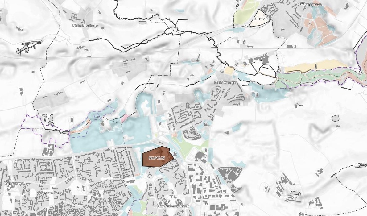
The Martlesham site, Portal Avenue, takes three patches of deciduous woodland. The other four lose slivers.
Ministry of Housing, Communities and Local Government, Planning Data platform: housing allocations in East Suffolk (Suffolk Coastal Local Plan 2020 and Waveney Local Plan). Natural England: Priority Habitats Inventory, Ancient Woodland and Sites of Special Scientific Interest (England), cut to within 1 km of the sites. Downloaded, attached and run on 15 November 2026.
From a list of sites to a screen of each one
Columns: ref (the plan’s site reference), name (the site’s name). 61 rows. One boundary for every site, with Natural England's priority habitats, ancient woodland and SSSIs attached beside it.
What you get, for every site
- Its area, in hectares.
- The priority habitat on it, by type, in hectares and as a share of the site.
- Ancient woodland, yes or no.
- The priority habitat nearby, within 250 m of the boundary.
- The nearest SSSI, by name, with its distance and whether it is within 1 km.
The protected land next door
Which sites sit close to an SSSI
Each site measured from its edge to the edge of the nearest Site of Special Scientific Interest, and named with it.
- Closest
- 48.1 mFormer Council Offices, Melton Hill, from the Deben Estuary SSSI
- Habitat and an SSSI
- 490.5 mthe Martlesham site from Ipswich Heaths: the one site that does both
- Named
- Every sitewith its nearest SSSI and the distance, however far away
| Within 1 km, closest first | Metres |
|---|---|
| Melton Hill · Deben Estuary | 48.1 |
| Levington · Nacton Meadows | 145.8 |
| Aldeburgh · Aldeburgh Brick Pit | 242.2 |
| Holton · Holton Pit | 412.2 |
| Westleton, B1125 · Minsmere-Walberswick | 454.4 |
| Martlesham · Ipswich Heaths | 490.5 |
| Westleton, Cherry Lee · Minsmere-Walberswick | 593.0 |
| Reydon · Pakefield to Easton Bavents | 749.0 |
| Woodbridge · Deben Estuary | 749.5 |
| Barnby · Barnby Broad & Marshes | 866.4 |
| Aldringham · Leiston - Aldeburgh | 898.1 |
| Corton · Corton Cliffs | 965.7 |
| Shottisham · Sutton and Hollesley Heaths | 990.8 |
The estuaries and heaths come first.
Two sites have the Deben Estuary as their nearest SSSI, and two in Westleton have Minsmere-Walberswick. Only the Martlesham site, in brown, also takes priority habitat.
Measured by Mapstack from the same files, 15 November 2026.
How it goes
You bring the sites and the layers. Mapstack does the measuring, the ranking and the map.
Attach the sites and the layers in one message.
Mapstack maps every site over the habitats and the SSSIs.
Find any site by its reference.
Common questions
What happens to our site boundaries?
It stays in your workspace. Only people with a seat in your workspace can see it. Nothing leaves unless you publish it yourself.
It is not used to train AI. Your data and your conversations are not used to train AI models.
It is still yours. You keep ownership of what you bring in. Delete it and it is removed.
The full answer is in the documentation: Your data, privacy and security.
What does it cost?
Free to start. One seat, for you, with a starter amount of work each month. No card.
The screening, the ranking and the map are on the free seat. With your own files and public sharing.
A written report is on a paid seat. Paid seats are per person, and bring more work each month.
The prices are on the pricing page.
What can I hand on?
The map. The sites, the habitats and the SSSIs, each layer in the legend to turn on and off.
The table. Every site and every measure, to download as a GeoPackage, GeoJSON or CSV.
The layers you brought. Each file stays its own dataset. The screened sites are a new one.
Screen your sites.
Free to start. Written reports on a paid seat.