
An ecological desk study
Map the ecological baseline around your site.
Attach your site boundary, Natural England's layers and your species records. You get one map of everything within 2 km, and the tables for your report.
Free to start. No card.
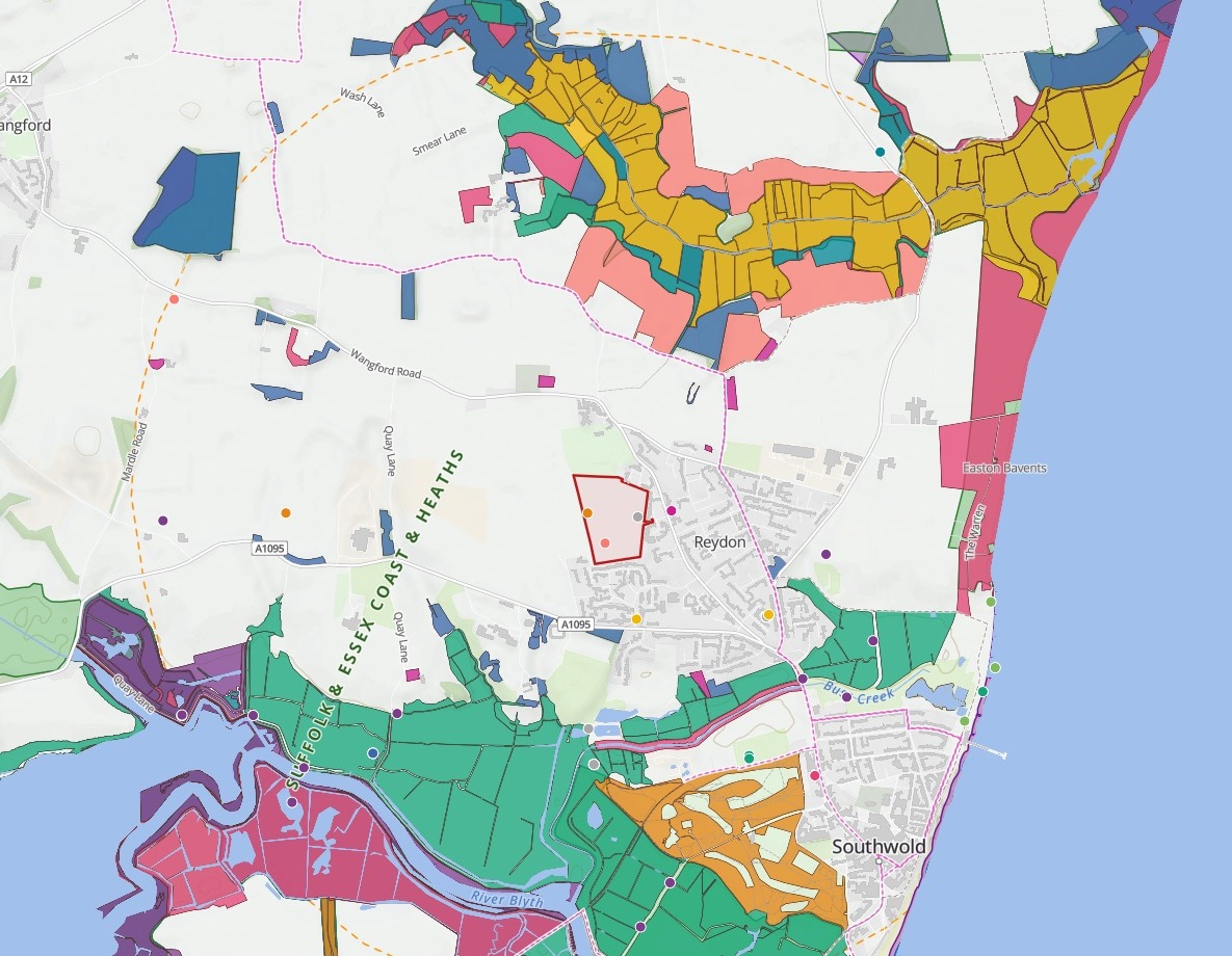
| Within 2 km of the site | |
|---|---|
| Site boundary | No priority habitat |
| 2 km search line | 10 sites and woods |
| Priority habitat, by type | 12 types |
| Protected species since 2016 | 13 species |
Eight files in one message. The map and three desk-study tables came back together.
One real site
The priority habitat within 2 km, type by type
A housing allocation of about 10 hectares at Reydon, on the Suffolk coast, with Natural England's Priority Habitat Inventory attached beside its boundary.
- On the site
- Noneno priority habitat inside the boundary itself
- Within 2 km
- 518.89 haof priority habitat, in 12 types
- Wetland
- 58%of it, by the six types you name
| Priority habitat within 2 km | Hectares | Wetland |
|---|---|---|
| Coastal and floodplain grazing marsh | 191.50 | Yes |
| No main habitat, additional habitats present | 105.40 | No |
| Lowland fens | 78.25 | Yes |
| Good quality semi-improved grassland | 45.51 | No |
| Deciduous woodland | 32.80 | No |
| Lowland heathland | 32.37 | No |
| Coastal saltmarsh | 16.81 | Yes |
| Reedbeds | 9.25 | Yes |
| Mudflats | 5.41 | Yes |
| Traditional orchard | 2.47 | No |
| Saline lagoons | 2.04 | Yes |
| Maritime cliff and slope | 0.08 | No |
Name the habitats you count as wetland, and it sorts the types for you.
Asked for grazing marsh, fens, reedbeds, saltmarsh, mudflats and lagoons, it marked those six in the table and totalled them: 303.26 ha.
Natural England, Priority Habitat Inventory (England), cut to a box about 2 km around the site. Site boundary: the government's Planning Data platform, housing allocation WLP6.1 in the Waveney Local Plan. Downloaded, attached and run on 15 November 2026.
For the ecologist doing the desk study
Before anyone walks the site, someone has to say what is already known around it.
The designated sites, the priority habitats, the protected species on record. That desk study goes into the Preliminary Ecological Appraisal, the PEA. Each layer comes from its own source, and every distance is measured from the red line, the site boundary.
The species records
Every protected species record since 2016, one square each
Records from the NBN Atlas of Schedule 1 birds, Schedule 5 species, European protected species and badger, filtered to 2016 onwards and to within 2 km of the boundary.
- Nearest
- 0 mbadger, great crested newt and kingfisher, recorded inside the boundary
- Records
- 55of 13 species since 2016, within 2 km
- Latest
- 2026for greylag goose, Cetti's warbler and barn owl
- Greylag goose
- 22
- Red kite
- 5
- Fieldfare
- 4
- Avocet
- 4
- Purple sandpiper
- 3
- Cetti's warbler
- 3
- Badger
- 2
- Barn owl
- 2
- Great crested newt
- 2
- Brambling
- 2
- Kingfisher, whimbrel and redwing
- 6
Each species comes with its protection.
The table gives each its scientific name, the law that protects it, its number of records, the most recent year and the nearest record.
NBN Atlas, records of species on the lists for Schedule 1 birds and Schedule 5 of the Wildlife and Countryside Act 1981, the Conservation of Habitats and Species Regulations and the Protection of Badgers Act, open-licence records only. Downloaded, attached and run on 15 November 2026.
How it goes
You bring the boundary and the layers. Mapstack does the measuring.
Attach the red line and your layers in one message.
Mapstack draws the baseline map, with the site on top.
You get every designated site, nearest first.
Common questions
What happens to our records and boundaries?
It stays in your workspace. Only people with a seat in your workspace can see it. Nothing leaves unless you publish it yourself.
It is not used to train AI. Your data and your conversations are not used to train AI models.
It is still yours. You keep ownership of what you bring in. Delete it and it is removed.
The full answer is in the documentation: Your data, privacy and security.
What does it cost?
Free to start. One seat, for you, with a starter amount of work each month. No card.
This job is on the free seat. Maps, datasets, analysis, your own files and public sharing are all included.
Pay per person for more. A paid seat brings more work each month, and seats for your team.
The prices are on the pricing page.
What goes into the report?
The baseline map. The site, the 2 km line, designated sites by type, ancient woodland, habitats by type and records by species.
The designated sites table. SSSIs, SACs, SPAs, Ramsar sites and ancient woodland, each with its distance from the boundary.
A search across the map. Find any species or site by name.
Map your baseline.
Free to start. No card.