
Location due diligence
Check whether a chain's shops are in good places.
Name the chain and the city. You get every shop on a map, with the people and rival shops around each, and the districts with room for more.
Free to start. Reports and prints on a paid seat.
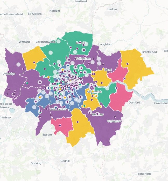
| London boroughs | Chain's shops |
|---|---|
| High penetration | 6+ |
| Moderate penetration | 3–5 |
| Low penetration | 1–2 |
| None yet, over 250,000 residents | 0 |
| None yet, fewer residents | 0 |
Nothing attached: the chain's 112 shops, ringed, and 407 rival shops, dotted in each brand's colour, were found in open map data.
For the location section of a deal
Before a bid, someone has to say whether the shops are in good places, and where the chain could open next.
Deal teams, lenders and buyers' advisers write it for an investment committee. It is the location part of commercial due diligence: the people around each shop, the rivals beside it, and the gaps.
The area around a shop is its catchment. Districts with plenty of people and none of the shops are what retailers call white space. Both come back measured the same way, for every shop and every district.
One real chain
Every shop, measured on the same 800 metres
A London bakery chain and four rival chains, found by Mapstack in open map data, with residents counted from Census 2021.
- Residents
- 19,404live within 800 metres of the average shop
- The most
- 34,657residents around the shop at Elephant and Castle
- Rivals
- 6.5rival shops within 800 metres, on average
| The most crowded shops | Rival shops within 800 metres |
|---|---|
| Soho | 43 |
| Shaftesbury Avenue | 41 |
| Covent Garden | 36 |
| Bedford Square | 34 |
| High Holborn | 33 |
It separates the crowded shops from the clear ones.
The most crowded are all in central London. Shops in Teddington, St Margarets, East Sheen and Chislehurst have no rival shop within 800 metres. The fewest residents, 5,156, live around a shop on Peter's Hill.
Shops: Overture Maps, release 2026-10-21. Residents: Office for National Statistics, Census 2021, by Output Area, shared out where a circle cuts one. Run on 14 November 2026.
How it goes
You name the chain and its rivals. Mapstack finds the shops and does the counting.
Name the chain and its rivals and the distance.
Mapstack finds every shop and maps it over the districts.
You get every shop, and every borough, in a table.
Room to grow
The boroughs with the most people and no shop
All 33 London boroughs, their Census 2021 residents set against the chain's shops in each.
- Most shops
- 16in Westminster, one for every 12,765 residents
- One shop only
- 367,115residents in Ealing, the largest borough with a single shop
- No shop yet
- 8boroughs, five of them with more than 250,000 residents
| Borough, no shop yet | Residents |
|---|---|
| Croydon | 390,719 |
| Newham | 351,036 |
| Lewisham | 300,553 |
| Havering | 262,052 |
| Harrow | 261,203 |
| Bexley | 246,472 |
| Barking and Dagenham | 218,869 |
| Sutton | 209,639 |
It ranks the gaps, and the near-gaps.
After Ealing, the largest boroughs with a single shop are Hillingdon, Waltham Forest, Merton and Kingston upon Thames. Camden comes next to Westminster, with 15 shops, one for every 14,009 residents.
Residents: Office for National Statistics, Census 2021, by London borough. Shops: Overture Maps, release 2026-10-21. Run on 14 November 2026.
The first pass is where it starts
The committee will ask more. Each of these is something you can ask for today.
Change the measure
A walk instead of a straight line, a tighter ring, another rival.
- Use a 10-minute walk from each shop instead of 800 metres.
- Count the rival shops within 400 metres as well, as a separate column.
- Add another rival chain and count it the same way.
Look closer at a gap
The biggest borough with no shop.
- Take Croydon, the borough with the most people and no shop, and show me where in it the most people live.
Then write it up
The answer is for a committee.
- Give me the shop table to download, with the residents and rivals for each.
- Write it up as a report for the investment committee.
- Make prints of the maps for the committee deck.
Common questions
Who can see the review?
It stays in your workspace. Only people with a seat in your workspace can see it. Nothing leaves unless you publish it yourself.
It is not used to train AI. Your data and your conversations are not used to train AI models.
It is still yours. You keep ownership of what you bring in. Delete it and it is removed.
The full answer is in the documentation: Your data, privacy and security.
What does it cost?
Free to start. One seat, for you, with a starter amount of work each month. No card.
The map and the tables are on the free seat. With your own files and public sharing.
A written report or a print is on a paid seat. Paid seats are per person, and bring more work each month.
The prices are on the pricing page.
Where do the figures come from?
The shops, from open map data. Mapstack fetches every shop of each brand you name.
The residents, from the census. Counted from the smallest census areas, shared out where a circle cuts one.
Each source, named. The reply says where every figure came from, and which release.
Review yours.
Free to start. Reports and prints on a paid seat.