
Animal movement from GPS collar data
Turn collar fixes into tracks and home ranges.
Attach your GPS collar fixes. You get each animal's track and home range on a map, and which animals migrated, where and when.
Free to start. Reports and prints on a paid seat.
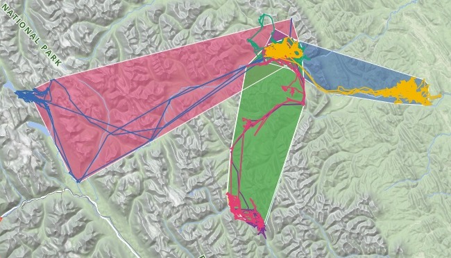
| Five elk, one year | |
|---|---|
| Collar fixes | 19,578 |
| Elk, each with a track and a home range | 5 |
Each line is one elk’s year of fixes. Each shaded shape is the area holding 95% of them.
For whoever writes up where the animals went
Wildlife biologists.Park ecologists.Field technicians.The fixes say where each animal was.
The annual summary needs where it lived, and when it moved.
A home range is the area an animal uses. Here it is an outline drawn around 95% of its fixes, with its area in square kilometres.
You say which columns hold the ID, the time and the position, and what share of the fixes a home range should hold. The tracks show the migration routes, and the rest is done for you.
One real herd
Five elk: one stayed, four went for the summer
Five adult female elk of the Ya Ha Tinda, on the eastern edge of Banff National Park in Alberta, through 2017, with a collar fix about every two hours. The fixes are the elk project’s own, as published on Movebank.
- Resident
- OR100stayed on the winter range all year
- First to leave
- April 18YL114_BL274, east into the foothills, back on November 8
- Furthest
- OR78the longest migration, and the largest home range of the five
| Elk | Winter to summer range | Home range, the year |
|---|---|---|
| OR78 | 54.1 km | 1,042 km² |
| YL168 | 39.8 km | 509 km² |
| OR56_BL251 | 37.4 km | 516 km² |
| YL114_BL274 | 29.5 km | 283 km² |
| OR100 | 0.7 km | 58 km² |
It dates every move.
OR78 left on May 22, OR56_BL251 on May 29 and YL168 on May 31, for the upper Red Deer, the Panther and Cascade valleys in Banff National Park, and the Panther River. They were back on August 23, September 9 and September 23.
Ya Ha Tinda elk project, Banff National Park, female elk: GPS collar fixes for 2017, Movebank Data Repository, released under CC0. Downloaded and attached on 15 November 2026, and run the same day.
How it goes
You bring the fixes. Mapstack builds the tracks, the ranges and the summary.
Attach the collar fixes and say what you need.
Mapstack maps every track and every home range.
You get the summary table.
Common questions
What happens to our collar data?
It stays in your workspace. Only people with a seat in your workspace can see it. Nothing leaves unless you publish it yourself.
It is not used to train AI. Your data and your conversations are not used to train AI models.
It is still yours. You keep ownership of what you bring in. Delete it and it is removed.
The full answer is in the documentation: Your data, privacy and security.
What does it cost?
Free to start. One seat, for you, with a starter amount of work each month. No card.
The tracks, home ranges, seasonal summary and table are on the free seat. With your own files and public sharing.
Reports and prints are on a paid seat. Paid seats are per person, and bring more work each month.
The prices are on the pricing page.
Map your animals.
Free to start. Reports and prints on a paid seat.