
Capital works coordination
Find the streets about to be dug up twice.
Attach the open dig permits for your area. You get every permit on a map, and a list of clashes where two holders dig close together at the same time.
Free to start. Prints and reports on a paid seat.
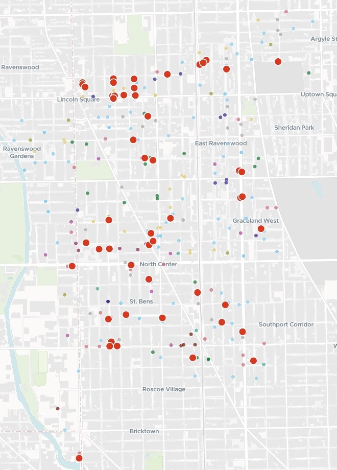
| Open dig permits, from 16 November 2026 | |
|---|---|
| Clash | 67 |
| Peoples Gas | Gas |
| ComEd North | Power |
| DWM, the city’s water department | Water |
| Seven-D Construction | Tree planting |
| G & V Construction | Contractor |
| Millennium Contracting | Contractor |
| Sumit Construction | Contractor |
| Reliable Contracting & Equipment | Contractor |
| Level 3 (Lumen) | Telecoms |
| Comcast | Telecoms |
| Other holders |
The clashes cluster around Lincoln Square, North Center and along Lawrence.
For whoever answers for the street
The gas company digs up the block.Then the power company, then the water department.
Residents want to know why nobody talked to each other.
Ward and council offices, right-of-way teams and utility coordinators keep watch on the street works. The permits are public. Which of them land on the same block at the same time is not.
Lining the works up so a street is opened once is capital works coordination. Some cities call it dig once, or joint trenching. Here you attach the permits, and Mapstack gives you the calls to make.
One real ward
Who to call, and on which street first
Chicago's open public way opening permits in the 47th Ward (Lincoln Square, North Center, Ravenswood) still running on or after 16 November 2026, from the city's open data.
- Streets
- 30with at least one clash between two holders
- Busiest pair
- 10clashes between Peoples Gas and Seven-D Construction, who plant the city’s street trees
- First call
- Lawrencetied with Bell for the most clashes; three of its seven are one water permit
| Streets with the most clashes | Clashes |
|---|---|
| Lawrence Avenue | 7 |
| Bell Avenue | 7 |
| Claremont Avenue | 6 |
| Ashland Avenue | 4 |
| Hoyne Avenue | 4 |
| Leavitt Street | 4 |
One permit can be many clashes.
One water department permit runs along nine stretches of street, from July to the end of December. It is in 7 clashes, three of them on Lawrence, so one call to the water department covers three of Lawrence’s seven.
City of Chicago Data Portal, Transportation Department Permits: public way opening permits in Ward 47, not closed, running on or after 16 November 2026. Run on 15 November 2026.
How it goes
You bring the permit list and say what counts as a clash. Mapstack does the pairing.
Attach the permits and set the rule.
Mapstack maps every permit and marks each clash in red.
You get the calls to make, street by street, to copy or download.
Then take it to the diggers
Each is something you can ask for today.
A print for the site meeting
One street, on paper.
- Print a map of Lawrence Avenue with its clashes and the permits around them.
A coordination report
To send to every holder.
- Write a coordination report: the clashes by street, with both holders, their permit numbers and their dates.
A link for the utilities
The same map, for anyone you send it to.
- Publish the map so the utilities and contractors can open it from a link.
Common questions
What happens to our permit list?
It stays in your workspace. Only people with a seat in your workspace can see it. Nothing leaves unless you publish it yourself.
It is not used to train AI. Your data and your conversations are not used to train AI models.
It is still yours. You keep ownership of what you bring in. Delete it and it is removed.
The full answer is in the documentation: Your data, privacy and security.
What does it cost?
Free to start. One seat, for you, with a starter amount of work each month. No card.
The map, the clashes and the list are on the free seat. With your own files and public sharing.
A print or a written report is on a paid seat. Paid seats are per person, and bring more work each month.
The prices are on the pricing page.
What counts as a clash?
The distance you set. Name it in the request, in metres or feet.
Dates that overlap. Each permit’s start and end, as the city issued it.
Two different holders. A holder’s own permits are not paired with each other, and each side is named.
Check your streets.
Free to start. Prints and reports on a paid seat.