
Food access and service gaps by area
Find neighbourhoods too far from a service.
Name the city, the service and your standard. You get the areas beyond the walk, those where few households have a car, and how many people live there.
Free to start. Briefing reports on a paid seat.
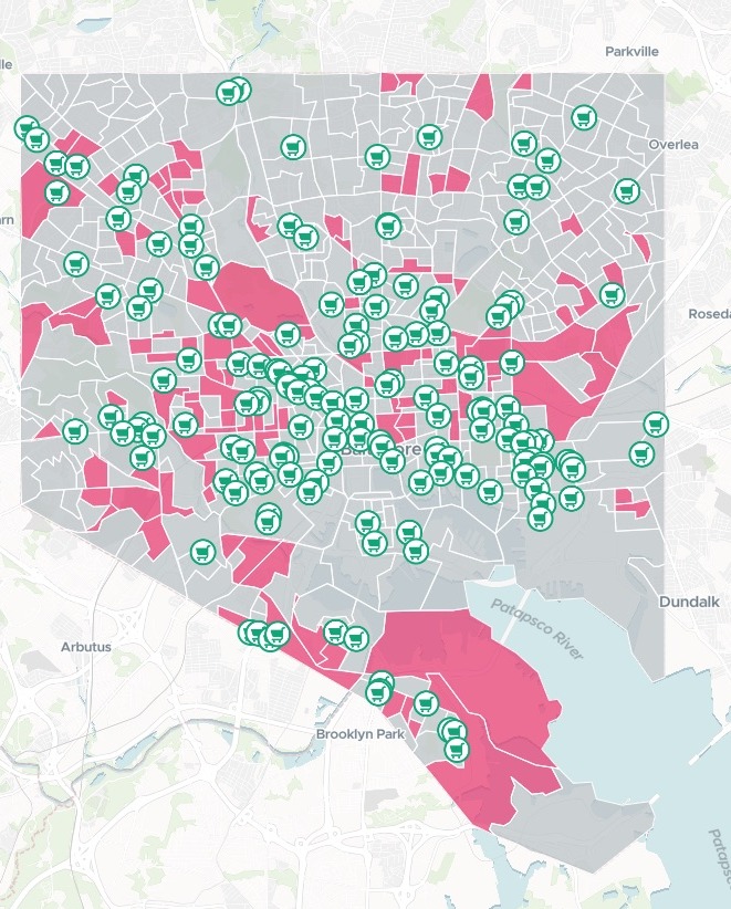
| On the map | |
|---|---|
| Block groups beyond the walk, where over 30% of households have no car | |
| Every other block group in the city | |
| Supermarkets and full‑service grocery stores | 158 |
Filters on the map let a reader move both tests: the share of area within the walk, and the share of households without a car.
For whoever has to show who is left out
A quarter-mile walk to a supermarket is a standard.
The people it fails most are the ones with no car to make up the distance.
Places with poor walking access to food and few cars are often called food deserts. The same test works for any service people walk to.
Here you name the city, the service and your standard. Mapstack fetches the places and the census figures itself, block group by block group: the small areas the census reports on.
One real city
Baltimore, a quarter-mile walk, and who has no car
A food access update for Baltimore City, with no file attached. Mapstack fetched the supermarkets and full-service grocery stores, and the census population and households without a car for every block group.
- Flagged
- 108block groups beyond the walk, where over 30% of households have no car
- People
- 93,649live in the flagged block groups
- Share of the city
- 16.22%of Baltimore City's 577,193 residents
| The ten largest flagged census block groups | Residents | Households without a car |
|---|---|---|
| Tract 2502.04, block group 2 | 3,558 | 71.3% |
| Tract 2803.02, block group 2 | 2,351 | 43.4% |
| Tract 2804.04, block group 1 | 1,950 | 47.9% |
| Tract 1504, block group 3 | 1,910 | 37.3% |
| Tract 1301, block group 2 | 1,843 | 45.2% |
| Tract 2604.02, block group 2 | 1,738 | 56.6% |
| Tract 2602.02, block group 5 | 1,704 | 33.8% |
| Tract 1202.02, block group 3 | 1,628 | 73.7% |
| Tract 2708.03, block group 2 | 1,559 | 37.9% |
| Tract 1002, block group 2 | 1,555 | 79.6% |
It says what it measured.
A block group counted as beyond the walk when more than half of its area lay further than a quarter-mile (1,320 ft) walk from a supermarket: 365 of the city's 618. The car test picked out the flagged ones among them. Each row is a census block group, named by its tract as the census names it.
Stores: Overture Maps open place data, which integrates OpenStreetMap. Population and households without a vehicle: US Census Bureau, American Community Survey 2019–2023 5-year estimates, by block group. Run on 14 November 2026.
How it goes
You bring the standard. Mapstack brings the stores, the census and the walk, in one turn.
Name the city, the service and your standard.
Mapstack finds the gaps and maps them with every store.
You get the gaps, and how they were measured.
The gaps are where it starts
Mapstack offered these next. Each of them is something you can ask for today.
Look closer
At the places that came out worst.
- Examine the neighbourhood clusters among the flagged block groups.
Another way there
For the people without a car.
- Find the bus stops in the flagged block groups, and count them for each.
Write it up
For the update you publish.
- Write a briefing report from these findings.
Common questions
What happens to our figures?
It stays in your workspace. Only people with a seat in your workspace can see it. Nothing leaves unless you publish it yourself.
It is not used to train AI. Your data and your conversations are not used to train AI models.
It is still yours. You keep ownership of what you bring in. Delete it and it is removed.
The full answer is in the documentation: Your data, privacy and security.
What does it cost?
Free to start. One seat, for you, with a starter amount of work each month. No card.
The analysis, the table and the map are on the free seat. With your own files and public sharing.
A briefing report is on a paid seat. Paid seats are per person, and bring more work each month.
The prices are on the pricing page.
Which places count?
Full-service stores. Corner bodegas, convenience-only markets, dollar stores and liquor stores were left out, and the answer said so.
Closed places removed. Stores marked permanently closed were dropped.
Every area opens up. Click a block group for its population, walk access and car figures.
Find yours.
Free to start. Briefing reports on a paid seat.