
Is this address in my area?
Check every address against your boundary.
Attach your area's boundary and a list of street addresses. You get your list back with an inside or outside column, the counts and a map.
Free to start. No card.
| For the storefront grant | |
|---|---|
| Inside SSA #33 | Eligible |
| Outside SSA #33 | Not eligible |
One dashed line, the district boundary, sorts a whole ZIP code of businesses.
For anyone whose rules stop at a line on the map
A grant only for businesses inside the district.Applications from across the ZIP code.
Every one checked against the line.
Testing whether each placed address falls inside a boundary is a point-in-polygon test. It answers "is this address in our area?" for a whole list at once.
Grants, service areas, catchments, zones: the same check works wherever a rule stops at a boundary.
One real list
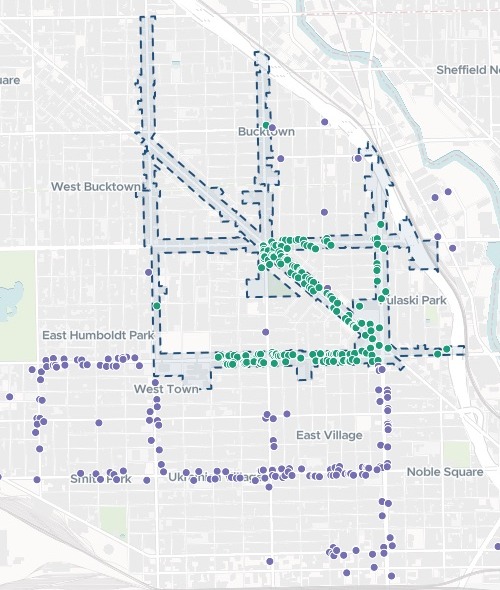
368 food businesses, one district, each one in or out
The City of Chicago's Special Service Area boundaries, and its active food business licences in ZIP code 60622, standing in for grant applications. The grant is only for businesses inside SSA #33, Wicker Park Bucktown.
- Eligible
- 181businesses inside SSA #33
- At the premises
- 362addresses placed at the exact building, the other 6 at the street
- Left unplaced
- 0every address on the list found
- Inside SSA #33
- 181
- Outside SSA #33
- 187
Naming the district was enough.
The City's file held all 58 of its Special Service Areas. Mapstack drew SSA #33 out as a boundary of its own, placed every address, and checked each one against it.
City of Chicago Data Portal: Boundaries – Special Service Areas, and Business Licenses – Current Active, retail food establishments in ZIP code 60622. Run on 15 November 2026.
Ask about one address in the same breath
Add the address that just came in to the same request.
An applicant just phoned about a new café at 1937 W Division St, Chicago, IL 60622: is that address inside SSA #33?
Yes, 1937 W Division St is inside SSA #33. The caller's new café location falls within the district boundary and is geographically eligible for the storefront grant.
How it goes
You bring the line and the list. Mapstack does the rest in one go.
Attach the boundary and your list of street addresses.
Mapstack places every address and checks it against the line.
You get your list back, one column more.
Common questions
What happens to our applicant list?
It stays in your workspace. Only people with a seat in your workspace can see it. Nothing leaves unless you publish it yourself.
It is not used to train AI. Your data and your conversations are not used to train AI models.
It is still yours. You keep ownership of what you bring in. Delete it and it is removed.
The full answer is in the documentation: Your data, privacy and security.
What does it cost?
Free to start. One seat, for you, with a starter amount of work each month. No card.
This job is on the free seat. Maps, datasets, analysis, your own files and public sharing are all included.
Pay per person for more. A paid seat brings more work each month, and seats for your team.
The prices are on the pricing page.
Will it work for my area?
Any boundary you have. A shapefile, as here, or another GIS file.
Street addresses are enough. No coordinates needed: each address is placed for you by geocoding.
The map searches by name. Find a business on the map, with a chart of inside and outside beside it.
Check yours.
Free to start. No card.