
A hazard score for every site
Score every site for fire, flood and earthquake.
Attach your sites and the published hazard zones. You get one score for each site by your own points, the list ranked, and a map.
Free to start. No card.
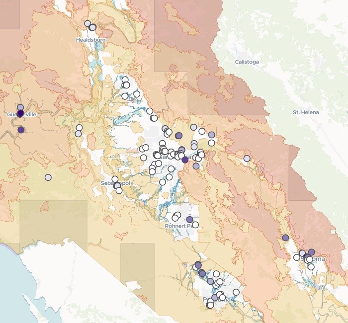
| Facilities by hazard score | Facilities |
|---|---|
| Score 5 | 4 |
| Score 4 | 2 |
| Score 3 | 10 |
| Score 2 | 8 |
| Score 1 | 22 |
| Score 0 | 87 |
The fire and flood zones lie underneath, muted, so the sites stand out.
For whoever has to say which sites are most exposed
Clinics, care homes, schools, depots and branches.Fire, flood and earthquake each have their own map.
The question is which of your sites face the most of them.
Rating each site on each hazard map, then adding the ratings into one number, gives a multi-hazard score. It turns three maps into one ranked list to plan evacuations and mitigation from.
Here you set the classes and the points. Mapstack lays every site over every zone, keeps to your rule, and hands back the list and the map.
Your sites, scored by your own rule
Columns: Facility (its name), Type (clinic, nursing home, hospital), Address (street, city, ZIP), Latitude, longitude (where it is). 133 rows. Attached with the fire, flood and fault zones, each cut to the county.
What you get
- A rating for each hazard, by the classes you name.
- The worse class wherever a site touches two of one hazard.
- One score, added up by your points.
- A count at each score, and the map.
One real county
Every licensed health care facility in Sonoma County, ranked
The state's list of licensed and certified health care facilities in Sonoma County, California, against CAL FIRE's fire hazard severity zones, FEMA's flood zones and the state's earthquake fault zones, in one message.
- At score 5
- 4facilities at the top score, three of them Russian River clinics in Guerneville
- Very High fire
- 5facilities rated Very High for wildfire, every one with a Sonoma address
- Earthquake fault
- 5facilities inside a fault zone, every one with a Santa Rosa address
| Facilities by rating | Facilities |
|---|---|
| High flood | 7 |
| Moderate flood | 4 |
| Very High fire | 5 |
| High fire | 9 |
| Moderate fire | 24 |
| Inside a fault zone | 5 |
Fire reaches the most sites.
38 of the 133 sit in a fire hazard zone, against 11 in a flood zone and 5 in a fault zone. The fault zones mark where the ground may break at the surface, not where it will shake.
California Department of Public Health, Licensed and Certified Healthcare Facility Listing, data date 15 July 2026. CAL FIRE Fire Hazard Severity Zones, state (2024) and local (2025) responsibility areas. FEMA flood zones effective 13 February 2026, from Sonoma County. California Geological Survey, Alquist-Priolo Earthquake Fault Zones. Each cut to the county, attached and run on 15 November 2026.
How it goes
You bring the list, the zones and your rule. Mapstack does the rest.
Attach your sites and the hazard zones and say how to score them.
Mapstack rates and scores every site and maps them over the zones.
You get the list, highest score first.
Common questions
What happens to our site list?
It stays in your workspace. Only people with a seat in your workspace can see it. Nothing leaves unless you publish it yourself.
It is not used to train AI. Your data and your conversations are not used to train AI models.
It is still yours. You keep ownership of what you bring in. Delete it and it is removed.
The full answer is in the documentation: Your data, privacy and security.
What does it cost?
Free to start. One seat, for you, with a starter amount of work each month. No card.
This job is on the free seat. Maps, datasets, analysis, your own files and public sharing are all included.
Pay per person for more. A paid seat brings more work each month, and seats for your team.
The prices are on the pricing page.
What comes back with each score?
The rule comes back first. Mapstack writes out the points it applied, above the table.
The ratings sit beside the score. Each row shows its wildfire, flood and fault rating, not only the total.
Every site opens on the map. Search by name, and its pop-up shows each rating and the score.
Score yours.
Free to start. No card.