
Geocode a list of addresses
Put coordinates on every address in your list.
Attach a spreadsheet with an address and postcode on each row. You get every one on a map by batch geocoding, and the list back with latitude and longitude added.
Free to start. No card.
| Care type | |
|---|---|
| Residential care | Four in five |
| Nursing care | One in five |
| Left unplaced | 0 |
Each home carries how precisely it was placed, ready to download.
For whoever keeps a list of places
Care homes.Schools.Branches.Customers.The list has an address on every row.
What it does not have is where each one is.
Until it does, the list cannot be mapped, measured against an area or handed to anyone who works with maps.
Here you attach the list as it is. Mapstack places every row, says how well each one matched, maps it, and gives the list back with the new columns.
Your list goes in. Your list comes back, placed.
Columns: Name (what each place is called), Address (street, village and town), Postcode (on every row), Service types (the kind of care), Date of latest check (kept as it is). 309 rows. An address and postcode on every row, no coordinates.
What you get
- Latitude and longitude on every row, none left out.
- How precisely each was placed: at the building, or at its postcode, in a column of its own.
- Every column you brought, downloadable as CSV for Excel, or as GeoJSON or GeoPackage for mapping software.
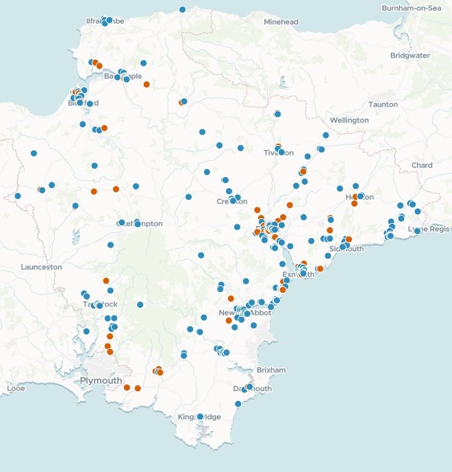
- A map coloured by type, with search by name, pop-ups and a chart added unasked.
One real register
A Plymouth address is not always a Plymouth home
The Care Quality Commission's register of residential and nursing homes in Devon. Plymouth and Torbay have councils of their own, so a home placed there would be someone else's to commission.
- Plymouth post town
- 4homes with a Plymouth postal address that are really in South Hams
- Dorset postcode
- 1home with a Lyme Regis address that is really in East Devon
- In the county
- 309homes, every one inside the county council’s area, none in Plymouth or Torbay
- In the county, as the address says
- 304
- Plymouth postal address, in South Hams
- 4
- Dorset postcode, in East Devon
- 1
It checks where a place is, not what the post says.
Royal Mail routes some Devon villages through a Plymouth post town, and one home near Lyme Regis has a Dorset postcode. Mapstack checked every home against the councils, named these five and said which council each is in.
Care Quality Commission, CQC care directory, 4 November 2026: residential and nursing homes in Devon. Run on 15 November 2026.
How it goes
You bring the list. Mapstack does the placing and the checking.
Attach your list and say how to colour it.
Mapstack places every address and makes the map.
You get the list back.
Common questions
What happens to my list?
It stays in your workspace. Only people with a seat in your workspace can see it. Nothing leaves unless you publish it yourself.
It is not used to train AI. Your data and your conversations are not used to train AI models.
It is still yours. You keep ownership of what you bring in. Delete it and it is removed.
The full answer is in the documentation: Your data, privacy and security.
What does it cost?
Free to start. One seat, for you, with a starter amount of work each month. No card.
This job is on the free seat. Maps, datasets, analysis, your own files and public sharing are all included.
Pay per person for more. A paid seat brings more work each month, and seats for your team.
The prices are on the pricing page.
How precisely is each one placed?
It says, row by row. A match quality column marks each place as matched at the building, or at its postcode.
Coordinates you have are used. Bring positions from your own address gazetteer and each place is mapped exactly there.
Any point can be moved. Edit the dataset on the satellite map and drag a point onto its building.
Place yours.
Free to start. No card.