
Canvass turf and walk lists
Split your addresses into canvass turfs.
Attach the addresses and say how big a turf should be. You get the turfs on a map to print, and a walk list for each.
Free to start. Printable sheets on a paid seat.
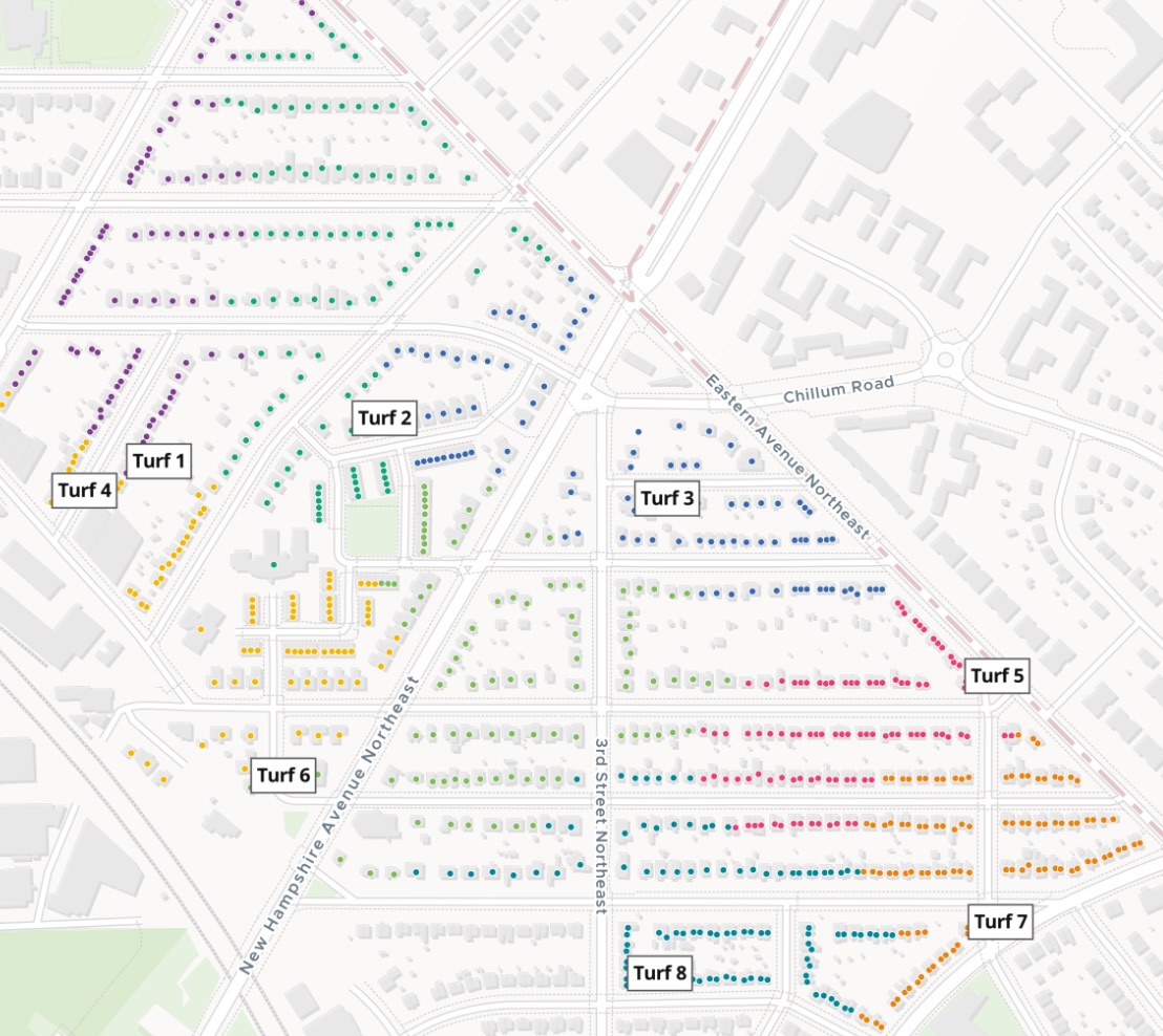
| Doors in each turf | Doors |
|---|---|
| Turf 1 | 104 |
| Turf 2 | 103 |
| Turf 3 | 99 |
| Turf 4 | 97 |
| Turf 5 | 97 |
| Turf 6 | 98 |
| Turf 7 | 105 |
| Turf 8 | 103 |
Eight turfs of 97 to 105 doors, each numbered on the sheet.
For whoever sends the volunteers out
Petition drives.Election weekends.Residents’ groups.Outreach teams.
A day of door-to-door volunteers, a list of addresses, and a patch for each person to knock.
Organisers call it cutting turf. Each volunteer’s patch is a turf; its addresses, in the order to knock them, are the walk list.
Here you attach the addresses and say how big a turf should be. Mapstack does the splitting, the counting and the map.
One real neighbourhood
Every door in a turf of about a hundred
Every active home address in Lamond-Riggs, a neighbourhood of Washington, DC, from the city's public address register, cut into turfs for a Saturday petition drive.
- Turfs
- 8each a patch for one volunteer, numbered on the map
- Doors
- 806counted from the addresses, a flat as its own door
- Addresses
- 785in the file, some holding more than one home
| Turfs with flats | Doors | Addresses |
|---|---|---|
| Turf 1 | 104 | 91 |
| Turf 4 | 97 | 90 |
| Turf 6 | 98 | 97 |
It counts doors, not addresses.
The register said how many homes each address holds. Mapstack counted those, so a turf with flats in it has more doors than addresses.
District of Columbia, Master Address Repository address points (Open Data DC), active residential addresses in single member district 4B10, downloaded 14 November 2026. Run on 14 November 2026.
One turf, one sheet
Check one before you print them all.
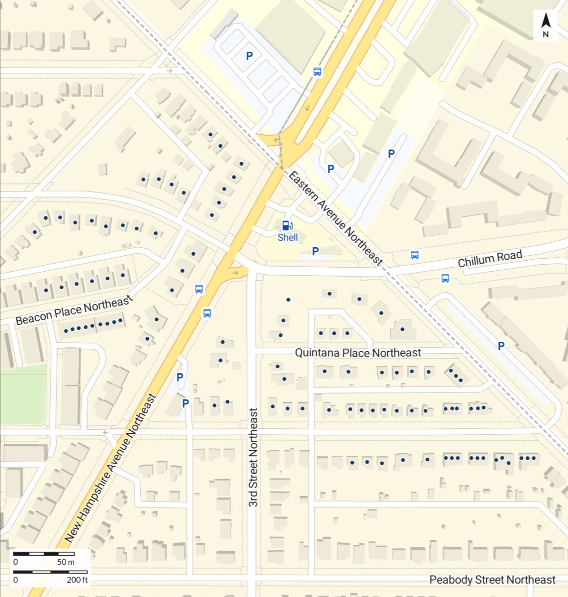
- Just that turf, at 1:2,500 on a Letter sheet turned landscape.
- Its homes as dots, with the street names, a scale bar and a north arrow.
- Its walk list in the reply: every address in knock order, street by street, to copy or download.
How it goes
You bring the addresses. Mapstack cuts the turf.
Attach the addresses and say how big a turf should be.
Mapstack cuts the turfs and maps them.
Each volunteer gets a walk list.
Then hand out the patches
Mapstack offered these next. Each is something you can ask for today.
A sheet each
One page per volunteer.
- Make a printable sheet for each of the other turfs.
The lists
For the clipboards.
- Give me Turf 2's walk list as a table I can print.
The team map
For captains on the day.
- Give the team captains a link to the turf map, so they can tap a house and see its turf.
Common questions
What happens to our address list?
It stays in your workspace. Only people with a seat in your workspace can see it. Nothing leaves unless you publish it yourself.
It is not used to train AI. Your data and your conversations are not used to train AI models.
It is still yours. You keep ownership of what you bring in. Delete it and it is removed.
The full answer is in the documentation: Your data, privacy and security.
What does it cost?
Free to start. One seat, for you, with a starter amount of work each month. No card.
The turfs, the walk lists and the map are on the free seat. With your own files and public sharing.
Printable turf sheets are on a paid seat. Paid seats are per person, and bring more work each month.
The prices are on the pricing page.
What does the list need?
One row per address. With where it is, as a city or council address register gives it.
How many homes each holds. So flats are counted door by door.
The size of a turf. In doors, in your request.
Cut your turf.
Free to start. Printable sheets on a paid seat.