
Aid distribution
Plan the relief deliveries.
Attach the places you are taking supplies to. You get a timed stop list for each truck, and a map of who is reached and who is still waiting.
Free to start. No card.
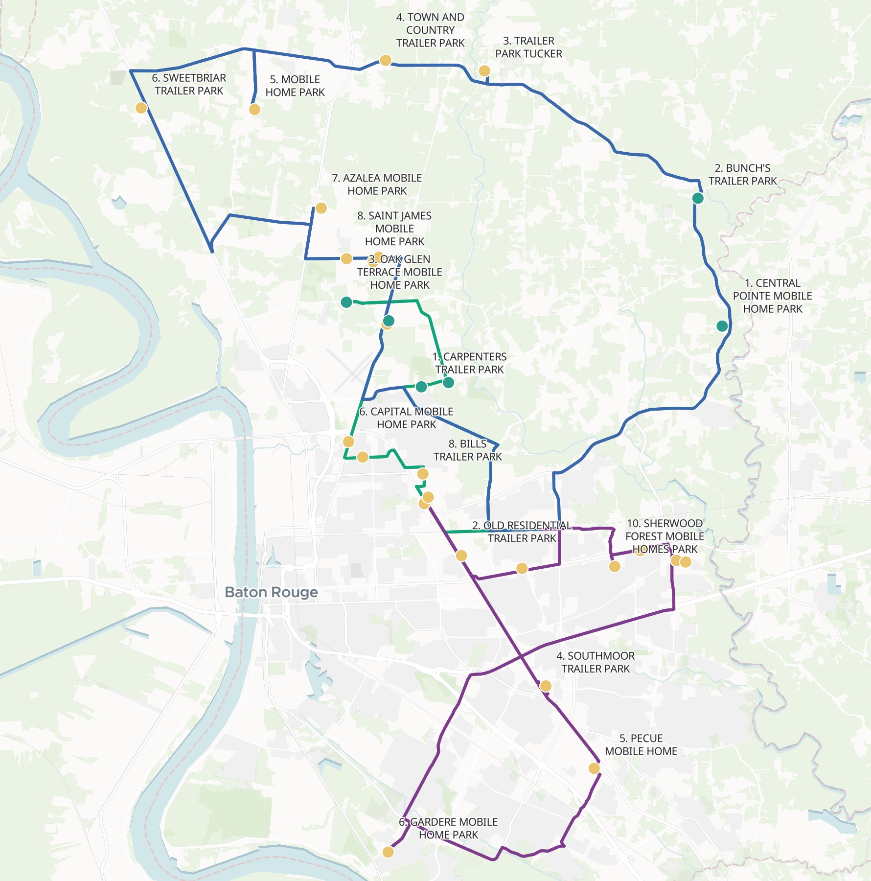
| After the first crews called in | Parks |
|---|---|
| Reached | 6 |
| Waiting | 24 |
| Truck 1, central and south-east | 10 |
| Truck 2, north Baton Rouge | 10 |
| Truck 3, Zachary and Baker | 10 |
Each route leaves the warehouse and comes back to it, its stops numbered in the order the truck reaches them.
For whoever gets the supplies out
Food banks.Church and volunteer teams.Councils and relief agencies.
The trucks are loaded: who goes where, and who is still waiting?
Sharing stops between vehicles and putting each run in order is multi-stop route planning. Keeping a map of who has had their delivery is tracking.
Here one request does both. You attach the list and say how many trucks you have; Mapstack plans the runs, and the map changes as the crews call in.
One real list
Three trucks, 30 parks, every arrival timed
The parish’s own public list of its mobile home parks in East Baton Rouge, Louisiana, planned as a relief team would plan it: three box trucks from one warehouse, half an hour to unload at each park.
- Shortest day
- 5 h 47 minTruck 2, round the Hooper Road and Plank Road parks
- Longest day
- 6 h 31 minTruck 3, out to Greenwell Springs, Zachary and Baker
- Last truck back
- 2:01 PMin the plan, all three trucks home by early afternoon
| Truck | Driving | Distance |
|---|---|---|
| Truck 1 | 70 min | 43.4 miles |
| Truck 2 | 47 min | 25.8 miles |
| Truck 3 | 91 min | 60.3 miles |
Every truck unloads for five hours. The road makes the difference.
Each truck got a stop list: the park, its address, when the truck arrives and when it leaves. Mapstack added up each day from the driving and the unloading, and named the part of the parish each truck covers.
City of Baton Rouge and Parish of East Baton Rouge open data, Mobile Home Park, rows updated 8 August 2026. Street map: MapTiler and OpenStreetMap contributors. Run on 15 November 2026.
Tell it who has been reached
As the crews call in, say which places they have finished.
The map reads from the stop list, so a place can also be ticked off by hand in the table, and the map follows.
Truck 2 has finished Carpenters, Four Seasons, Oak Glen Terrace and Kleinpeter, and Truck 3 has done Central Pointe and Bunch’s. Mark those six as reached. How many are still waiting on each truck?
Mapstack marked the six reached and recoloured the map, reached in green and waiting in amber. It counted what each truck still had to do, named each truck’s next stop, and put the whole operation at 20% complete.
How it goes
You bring the list, the trucks and the start time. Mapstack plans the runs.
Attach the places and say where the trucks load.
Mapstack plans the routes along the roads, and maps every stop.
Each truck gets its stop list.
Common questions
What happens to our delivery list?
It stays in your workspace. Only people with a seat in your workspace can see it. Nothing leaves unless you publish it yourself.
It is not used to train AI. Your data and your conversations are not used to train AI models.
It is still yours. You keep ownership of what you bring in. Delete it and it is removed.
The full answer is in the documentation: Your data, privacy and security.
What does it cost?
Free to start. One seat, for you, with a starter amount of work each month. No card.
This job is on the free seat. Maps, datasets, analysis, your own files and public sharing are all included.
Pay per person for more. A paid seat brings more work each month, and seats for your team.
The prices are on the pricing page.
Plan yours.
Free to start. No card.