
Zoning map maintenance
Check your zoning map against every rezoning.
Attach your zoning map and your rezoning case log. You get each approved case checked, what is wrong named, and the rezoned zones outlined on a map.
Free to start. No card.
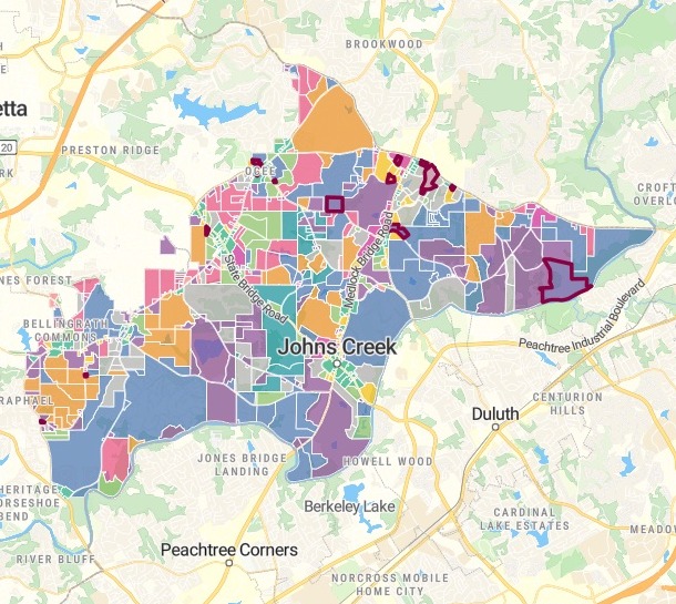
| Zoning by class | |
|---|---|
| Rezoned since 2024, outlined | |
| CUP, community unit plan | |
| R-4A, single family | |
| R-4, single family | |
| R-3, single family | |
| AG-1, agricultural | |
| C-1, community business | |
| Other classes |
Five zones corrected from the case log, and one left for you to decide.
For whoever keeps the official zoning map
Council approves a rezoning.Someone carries it onto the map: the new zoning class, the case number, the date.
Before the map is signed off, someone checks that every one made it.
Each approved rezoning is a zoning map amendment. The case log says what council decided; the map should say the same at the site.
Here your AI teammate takes each case’s point from the log, finds the zone under it and compares the two field by field.
One real city
15 approved rezonings, checked against the map
The City of Johns Creek, Georgia: its published zoning map and its rezoning case log since January 2024, both from the city’s open data.
- Disagreed
- 6cases where the map did not say what council decided
- Corrected
- 5zones, from the case log
- Left for you
- 1case whose logged date was a Sunday; the map kept the Monday of the council meeting
- Right on the map already
- 9
- Corrected from the case log
- 5
- Left for you to decide
- 1
It corrects only what the log settles.
Where the log itself looked doubtful, it said so and left the map as it was.
City of Johns Creek, Georgia, Zoning (Current) and Rezoning Cases, ArcGIS Hub open data, downloaded 15 November 2026. Run on 15 November 2026.
What it found on the map
Wrong decision dates on three zones. One still carried a date from 2007 for a case decided in September 2026.
A case number recorded as “none”, and the class spelled R4-A instead of R-4A.
An earlier case still on the zone. The 2024 decision was never carried onto it, so it showed a 2022 case and its date.
Two things it was not asked about: an old 2001 zone still lying under a 2024 rezoning, and two zones sharing one ID.
How it goes
You bring the map and the case log. Mapstack does the checking.
Attach the zoning map and the case log and ask for the check.
Mapstack checks each site and outlines the rezoned zones.
You get a verdict for each case.
Common questions
What happens to our zoning map?
It stays in your workspace. Only people with a seat in your workspace can see it. Nothing leaves unless you publish it yourself.
It is not used to train AI. Your data and your conversations are not used to train AI models.
It is still yours. You keep ownership of what you bring in. Delete it and it is removed.
The full answer is in the documentation: Your data, privacy and security.
What does it cost?
Free to start. One seat, for you, with a starter amount of work each month. No card.
This job is on the free seat. Maps, datasets, analysis, your own files and public sharing are all included.
Pay per person for more. A paid seat brings more work each month, and seats for your team.
The prices are on the pricing page.
Does it change our official map?
Your file stays as it was. The fixes are made on Mapstack’s copy, each listed zone by zone from the old value to the new.
Doubtful cases are left to you. Withdrawn and denied cases are set aside, and a log entry that looks wrong is named, not followed.
Take the fixes back to your GIS. Download the corrected zones as a GeoPackage, or send the list to whoever edits the map.
Check yours.
Free to start. No card.