
Open data publishing
Publish your open data as a map to explore.
Attach the export from your open data portal. You get a map of every record by kind, with the source, licence, attribution and date on it.
Free to start. Prints and reports on a paid seat.
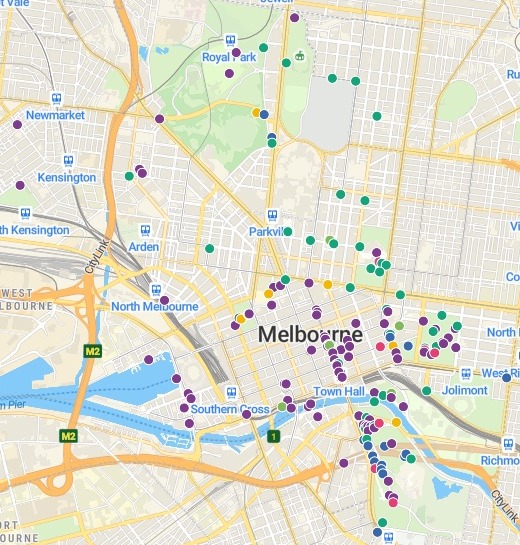
| By kind | Records |
|---|---|
| Sculpture | 85 |
| Fountain or drinking fountain | 40 |
| Memorial | 18 |
| Monument | 7 |
| Statue or bust | 7 |
| Other artwork or feature | 5 |
And one sundial. Each record keeps its original description beside its kind.
For whoever publishes the open data
The register sits on the portal as a spreadsheet.
Residents want to see it; researchers want the file, and to know they may reuse it.
Open data is published for anyone to reuse, under a licence that says how, such as CC BY 4.0, a Creative Commons licence.
Here you attach the export. Mapstack tidies it, maps it and puts the licence where a visitor reads it.
From the portal export to a map
Columns: Description (collection and kind, run together), Title (the name of each work), Co-ordinates (latitude and longitude, as text). 163 rows. The City of Melbourne's own export, as it sits on its open data portal.
What you get
- Every record on its own spot, read from the one text column.
- A plain kind for each: sculpture, fountain, memorial and four more, with the original text kept beside it.
- Name and kind on a tap, a search by name and a chart of the kinds.
- The licence on the map: its About panel names the source, CC BY 4.0, the attribution line and the date the data is current to.
Ask for the words that say how it may be reused
Say who publishes it and under which licence.
Ready to paste into your catalogue.
Write the dataset's description so someone who finds it knows what it holds, who publishes it, which licence it is under and what that lets them do.
Published by the City of Melbourne under Creative Commons Attribution 4.0 International (CC BY 4.0). Users are free to share, copy and adapt the material for any purpose, including commercially, provided they include the attribution: "Contains data from the City of Melbourne". Data current to 3 September 2026.
How it goes
You bring the export. Mapstack makes the map. You publish it.
Attach the export and name the licence.
Mapstack maps every record by kind.
You publish both when you are ready.
Go further
The same register, for people who will not open a map.
On paper
A sheet to pin up or hand out.
- Make a printable map of the memorials and sculptures, coloured by kind, with the licence and attribution on it.
In writing
The collection, described.
- Write a short report on the collection: how many of each kind there are, and where they are.
Common questions
What happens to our register?
It stays in your workspace. Only people with a seat in your workspace can see it. Nothing leaves unless you publish it yourself.
It is not used to train AI. Your data and your conversations are not used to train AI models.
It is still yours. You keep ownership of what you bring in. Delete it and it is removed.
The full answer is in the documentation: Your data, privacy and security.
What does it cost?
Free to start. One seat, for you, with a starter amount of work each month. No card.
The map and the dataset are on the free seat. With your own files and public sharing.
A print or a report is on a paid seat. Paid seats are per person, and bring more work each month.
The prices are on the pricing page.
What does a visitor get?
The public map, with no account. Anyone with the link can explore it, search it and open its table.
The kinds, counted. A chart of how many of each, and kinds to switch on and off.
The file. Publish the dataset too, and its page offers it as CSV, GeoJSON or GeoPackage.
Publish yours.
Free to start. Prints and reports on a paid seat.