
A sales territory map for a rep
Give a new sales rep a map of their patch.
Attach your account list and name the districts. You get a map of the patch for the rep's phone, with every account placed and the districts drawn and labelled.
Free to start. Reports, prints and private sharing on a paid seat.
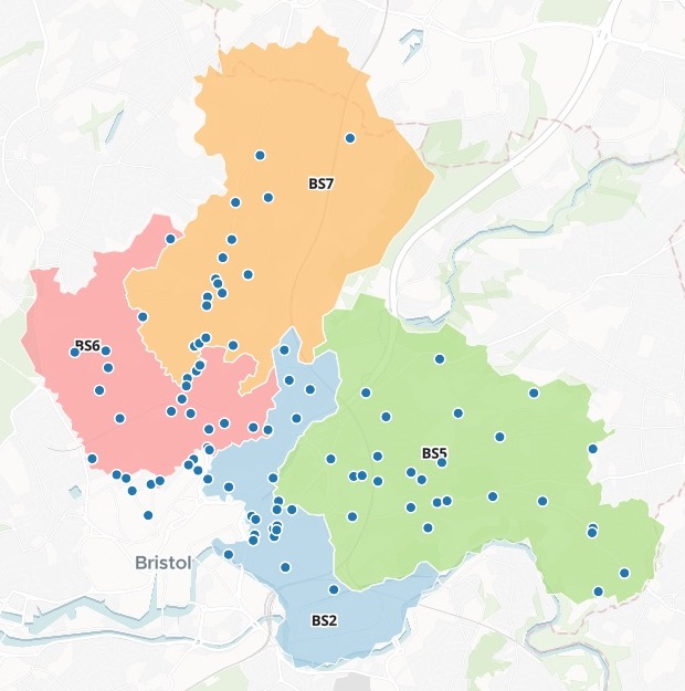
| The patch | |
|---|---|
| BS2 | St Pauls |
| BS5 | Easton |
| BS6 | Redland |
| BS7 | Horfield |
| Accounts | Pubs and bars |
Every account placed from its address, and counted by district.
For whoever hands a patch to a new rep
A rep starts on Monday.The patch is new to them, and the accounts are rows in a spreadsheet.
They need to see where the patch starts and stops, and where every account is.
That is a sales territory map: the patch drawn by its districts, the accounts on top, each one a tap from its address.
Here you attach the list and name the districts. Mapstack brings the boundaries and places the accounts itself.
One real patch
Every account on the map, counted by district
Pubs and bars in four Bristol postcode districts, from the Food Standards Agency's public register, standing in for a small brewery's account list. The file held names and addresses, and no coordinates.
- Boundaries
- 36district boundaries in the Bristol set Mapstack fetched. You bring no boundary file.
- Districts
- 4shaded, labelled and counted, each with its share of the patch
- Accounts
- 109placed from their addresses, each one a square in the chart
- BS2
- 35
- BS5
- 29
- BS7
- 25
- BS6
- 20
BS2 is the busiest district.
Mapstack gave the counts as a table, with each district's share of the patch: nearly a third of the accounts sit in BS2.
Food Standards Agency, Food Hygiene Rating Scheme open data, Bristol City Council, pubs, bars and nightclubs in BS2, BS5, BS6 and BS7, downloaded 14 November 2026. Postcode district boundaries: a Bristol set fetched by Mapstack, with BS2 drawn from its neighbours' edges. Run on 14 November 2026.
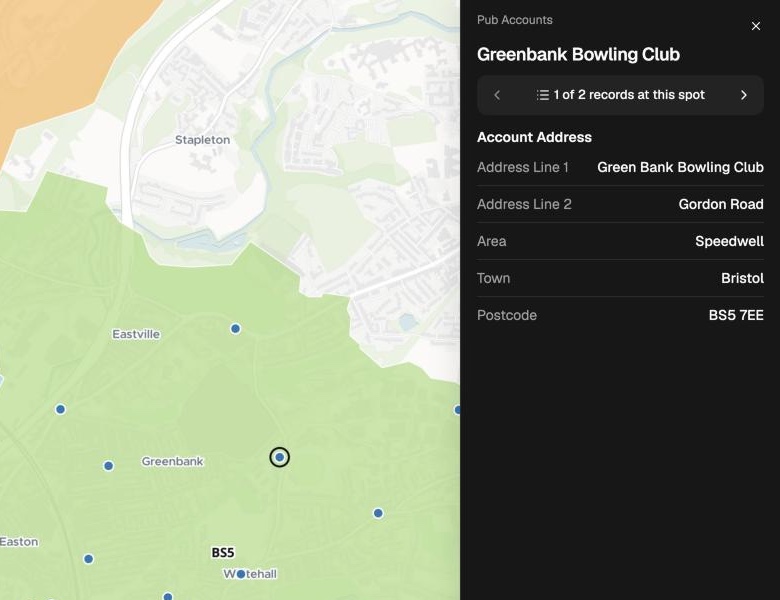
Tap an account for its address
The rep plans the day from the map.
- Name and full address: street, area, town and postcode.
- Every account: on top of its district, ready to tap.
- A search box: type a pub's name to jump to it.
How it goes
You bring the list. Mapstack draws the patch and places every account.
Attach the accounts and name the districts.
Mapstack draws the patch and places every account.
You send the rep a link.
The map is where the rep starts
Mapstack offered these next. Each is something you can ask for today.
Sort the accounts
By what matters to you.
- Colour the accounts by the tier in our list.
Plan the visits
For days on the road.
- Make printable route sheets for each district.
Brief the rep
Before their first day.
- Write the rep a briefing report on the patch.
Common questions
What happens to our account list?
It stays in your workspace. Only people with a seat in your workspace can see it. Nothing leaves unless you publish it yourself.
It is not used to train AI. Your data and your conversations are not used to train AI models.
It is still yours. You keep ownership of what you bring in. Delete it and it is removed.
The full answer is in the documentation: Your data, privacy and security.
What does it cost?
Free to start. One seat, for you, with a starter amount of work each month. No card.
The map, the counts and the link are on the free seat. With your own files and public sharing.
Route sheets, a briefing report and adding the rep to your workspace are on a paid seat. Paid seats are per person, and bring more work each month.
The prices are on the pricing page.
What does the list need?
Names and addresses. Street, town and postcode. No coordinates.
The patch, in words. Name the postcode districts in the request.
One link for the rep. Publish it to open from a phone, or add the rep to your workspace on a paid seat.
Map your patch.
Free to start. Reports, prints and private sharing on a paid seat.