
A franchise territory map
Draw a franchisee's protected territory.
Type the ZIP codes in the agreement. You get the territory on a map, its people and households from the census, and whether it meets your standard.
Free to start. Print-ready exhibits on a paid seat.
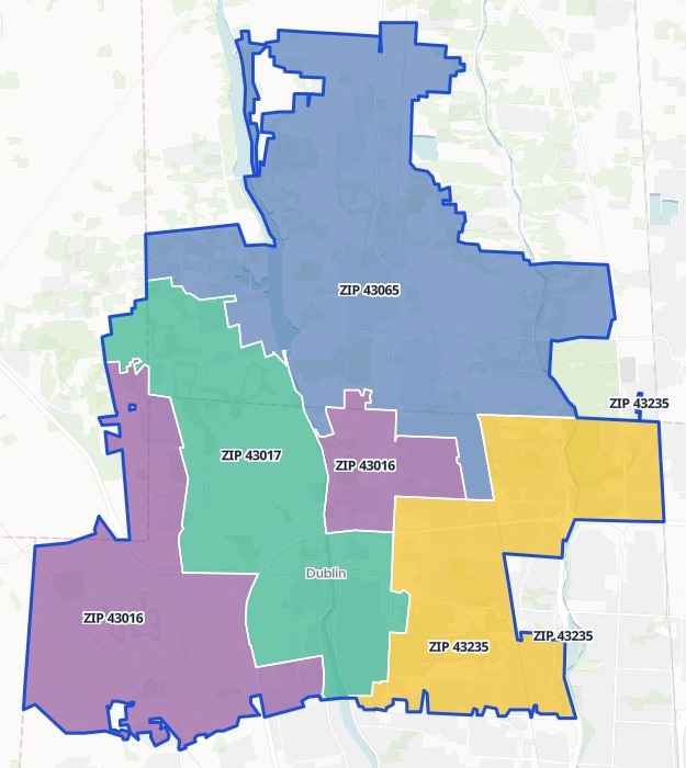
| Households, by ZIP code | Households |
|---|---|
| 43016 | 18,423 |
| 43017 | 16,223 |
| 43065 | 15,952 |
| 43235 | 19,888 |
Counted from the 2020 Census, for each ZIP code and the whole territory, inside the blue outline.
For whoever grants the territory
A franchisee is about to sign.The agreement names the ZIP codes that will be theirs alone.
Before anyone signs, the territory has to be drawn, and checked against your standard.
Franchisors call it a protected territory, or an exclusive territory: the area no other franchisee may work. The census says what it holds.
Here you type the ZIP codes. Mapstack fetches the census figures and the ZIP code boundaries itself, with no file to attach.
One real territory
Yes, with households to spare
Four ZIP codes around Dublin, Ohio, for a new franchisee of a residential cleaning franchise, checked against a standard set in households.
- Households
- 70,486in the territory: 30,486 more than the standard of 40,000
- People
- 178,526living in the four ZIP codes, from the same census
- Owners only
- 44,468owner-occupied households. Count only those, and it still passes.
| ZIP code | Homeownership | Owner-occupied |
|---|---|---|
| 43065, Powell | 87.5% | 13,961 |
| 43017, Dublin | 65.5% | 10,632 |
| 43016, Dublin | 53.4% | 9,831 |
| 43235, Columbus | 50.5% | 10,044 |
Counted from the census, ZIP code by ZIP code.
The 2020 Census count, by ZIP Code Tabulation Area: the Census Bureau's version of a ZIP code.
US Census Bureau, 2020 Census Demographic and Housing Characteristics, by ZIP Code Tabulation Area, Ohio. ZIP codes 43016, 43017, 43065 and 43235, named in the request. Run on 14 November 2026.
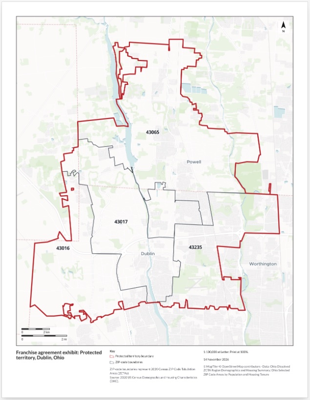
The exhibit for the contract
One US Letter page, to attach as a PDF.
- The territory and its ZIP codes: the boundary in red, each ZIP code outlined and labelled.
- A title block: north arrow, scale bars, the date and the source. Print it at 100%.
- A schedule to paste in: the household table came in the chat, set out for the agreement.
How it goes
You bring the ZIP codes and your standard. Mapstack brings the census.
Name the ZIP codes and your standard.
Mapstack draws the territory and counts what it holds.
You get the answer, then the exhibit.
Common questions
What does it cost?
Free to start. One seat, for you, with a starter amount of work each month. No card.
The territory, the counts and the map are on the free seat. With your own files and public sharing.
The exhibit as a PDF is on a paid seat. Paid seats are per person, and bring more work each month.
The prices are on the pricing page.
What happens to our territory details?
It stays in your workspace. Only people with a seat in your workspace can see it. Nothing leaves unless you publish it yourself.
It is not used to train AI. Your data and your conversations are not used to train AI models.
It is still yours. You keep ownership of what you bring in. Delete it and it is removed.
The full answer is in the documentation: Your data, privacy and security.
Where do the figures come from?
The US census. Fetched for you, ZIP code by ZIP code.
Named in the answer. The source is in the reply, and on the exhibit.
Each ZIP code opens up. Click one on the map for its people and households.
Draw your territory.
Free to start. Print-ready exhibits on a paid seat.