
Borehole siting from the geology
Choose where to drill from the well records.
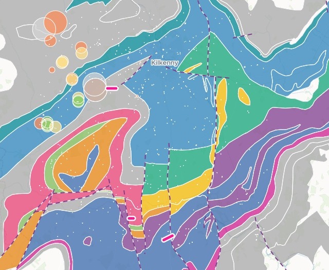
Attach the bedrock geology, the mapped faults and the borehole records. You get them on one map, with proposed places to drill under your spacing rule.
Free to start. Reports and prints on a paid seat.
| Three places to drill | Hole depth |
|---|---|
| Goodwinsgarden, Aghmacart Formation | 50–60 m |
| Damma, Ballyadams Formation | 60–80 m |
| Baunreagh, Ballysteen Formation | 70–90 m |
Each one more than 500 m from any good or excellent borehole.
For anyone siting a well in hard rock
In fractured rock, a borehole gives what the rock unit and the faults allow.
The best evidence is the wells already drilled.
Every borehole on record says what the ground gave: a yield class, how deep the rock was, how deep the hole went. Read against the geology, the well records say where to drill next.
Here you attach the geology, the faults and the records. Mapstack puts them on one geology map, reads them together and proposes the sites.
One real set of records
Where the good yields come from, around Kilkenny
Geological Survey Ireland's bedrock geology, mapped faults and borehole records for a 20 km square around Kilkenny city, where a group water scheme needs about 250 m³ a day from one new borehole.
- Excellent yields
- 329 mtheir median distance from a mapped fault, against 1,378 m for good ones
- Drilled to
- 90 mthe median depth of the excellent boreholes, with bedrock about 11 m down
- The main aquifer
- 33good and excellent boreholes in the Ballyadams Formation, more than in any other rock
| Rock unit | Good and excellent boreholes |
|---|---|
| Ballyadams Formation | 33 |
| Aghmacart Formation | 8 |
| Ballysteen Formation | 8 |
| Waulsortian Limestones | 5 |
| Butlersgrove Formation | 5 |
It says why the best yields sit near faults.
Faulting opens fractures in the limestone and widens channels in it, and a yield as large as the scheme needs depends on them.
Geological Survey Ireland: Bedrock Geology 1:100,000 and its faults, and Groundwater Wells and Springs, for a 20 km square around Kilkenny city. Contains Irish Public Sector Data (Geological Survey Ireland) licensed under CC BY 4.0. Run on 15 November 2026.
From the national well records to three sites
Columns: YIELDCLASS (excellent, good, moderate, poor or failure), YIELD_M3D (the yield, in m³ a day), HOLEDEPTHM (how deep the hole went). 551 rows. With the depth to bedrock and the townland, and the bedrock geology and the faults beside them, as shapefiles.
What you get
- One map of the rock units, the faults and the boreholes by yield class.
- The good and excellent yields counted by rock unit, and measured to the nearest fault.
- Their typical depths to bedrock and to the bottom of the hole.
- Sites that keep your rule, each with the reason it was chosen.
How it goes
You bring the geology and the records. Mapstack reads them together and proposes the sites.
Attach the three files and give your spacing rule.
Mapstack maps them together and marks the sites.
Each site comes with its reasons.
Then take it to the trustees
Each is something you can ask for today.
A report for the trustees
The case for each site, written up.
- Write a siting report for the scheme’s trustees: the evidence, the three sites and the reason for each.
The water strikes
From the borehole logs.
- At what depths did the good and excellent boreholes strike water?
A sheet for the committee
The same map, on paper for the committee or the driller.
- Make an A3 print of the map with the three sites, for the committee.
Common questions
What happens to our well records?
It stays in your workspace. Only people with a seat in your workspace can see it. Nothing leaves unless you publish it yourself.
It is not used to train AI. Your data and your conversations are not used to train AI models.
It is still yours. You keep ownership of what you bring in. Delete it and it is removed.
The full answer is in the documentation: Your data, privacy and security.
What does it cost?
Free to start. One seat, for you, with a starter amount of work each month. No card.
The map, the reading of the records and the sites are on the free seat. With your own files and public sharing.
A written report or a print is on a paid seat. Paid seats are per person, and bring more work each month.
The prices are on the pricing page.
What comes with each site?
Where it is. Its townland and grid reference, marked on the map.
The ground. The rock unit, the distance to the nearest mapped fault and the expected depth to bedrock.
The drilling. A target hole depth, and the reason for the site.
Site yours.
Free to start. Reports and prints on a paid seat.