
An excavation grid
Lay a numbered grid over your dig.
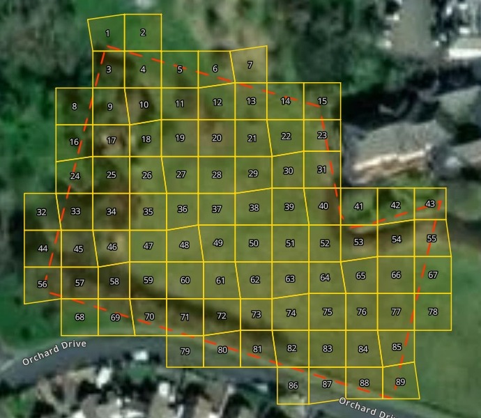
Attach your site boundary. You get numbered recording squares over it, a table of each square's corner for setting out, and the grid on an aerial photo.
Free to start. No card.
| On the map | |
|---|---|
| 10 m recording squares | 89 |
| Scheduled monument boundary |
Every square wholly or partly inside the boundary is kept.
For whoever runs the dig
Site directors.Field archaeologists.Community digs with a team of volunteers.
Every find is recorded by its square, so the squares come first: on the plan, and on the ground.
A recording grid divides the site into numbered squares. Marking them on the ground is setting out, and for that the team needs each square’s corner as an easting and northing.
Here you attach the boundary as a GIS file. Mapstack lays the grid, numbers it and writes the table.
One real site
A Roman villa in 10 m squares
The scheduled area of Dan-y-Graig Roman villa in Porthcawl, Wales: one boundary from Cadw’s register of scheduled monuments, downloaded as a shapefile.
- Squares
- 89numbered from 1 at the north-west tip, row by row, west to east
- Rows
- 11from 2 squares at the tip to 12 across the middle
- Set out by
- GPSevery square’s south-west corner as a National Grid easting and northing
| Squares in each row, north to south | Squares |
|---|---|
| Squares 1 to 2 | 2 |
| Squares 3 to 7 | 5 |
| Squares 8 to 15 | 8 |
| Squares 16 to 23 | 8 |
| Squares 24 to 31 | 8 |
| Squares 32 to 43 | 12 |
| Squares 44 to 55 | 12 |
| Squares 56 to 67 | 12 |
| Squares 68 to 78 | 11 |
| Squares 79 to 85 | 7 |
| Squares 86 to 89 | 4 |
Every corner falls on a round ten metres.
Lined up with the National Grid, the corners sit ten metres apart in whole metres. Short to read out on site, quick to key into the GPS.
Cadw (the Welsh Historic Environment Service), Scheduled Monuments, GM587 Dan-y-Graig Roman villa, from DataMapWales, downloaded 15 November 2026 (Open Government Licence v3.0). Run on 15 November 2026.
Take the grid into the trench
Ask for the map the team will carry on a tablet.
Share the map, and the field team opens it on their own tablets.
Put the aerial photo, the scheduled boundary and every square labelled with its number on one map, so the team can use it on a tablet in the trench.
Tap a square for its south-west easting and northing. Type 42 in the search and square 42 opens: 284,060 m east, 178,020 m north. The tablet’s GPS shows where you are standing on the grid.
How it goes
Attach the site boundary and say how big the squares are.
Mapstack lays the grid over the aerial photo.
You get the setting-out table. One row for every square.
Common questions
What happens to our site boundary?
It stays in your workspace. Only people with a seat in your workspace can see it. Nothing leaves unless you publish it yourself.
It is not used to train AI. Your data and your conversations are not used to train AI models.
It is still yours. You keep ownership of what you bring in. Delete it and it is removed.
The full answer is in the documentation: Your data, privacy and security.
What does it cost?
Free to start. One seat, for you, with a starter amount of work each month. No card.
This job is on the free seat. Maps, datasets, analysis, your own files and public sharing are all included.
Pay per person for more. A paid seat brings more work each month, and seats for your team.
The prices are on the pricing page.
What can the team take away?
The table. Every square’s number and corner, in the reply, to copy into your setting-out sheet.
The grid itself. Download it as GeoPackage or GeoJSON for QGIS or ArcGIS.
The map. Shared with the field team, numbered and searchable by square.
Grid yours.
Free to start. No card.