
Field boundary changes for a farm claim
Redraw your field boundaries when a fence moves.
Attach your fields and say what changed. You get the split and the merge made, and a new field list with areas, on a satellite map.
Free to start. No card.
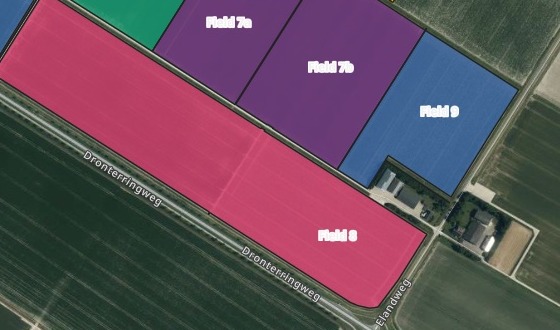
| In the picture, by crop | Fields |
|---|---|
| Potatoes | 7a, 7b |
| Onions | 8 |
| Winter wheat | 9 |
The other seven fields are as they were on the register.
For whoever keeps the field map true
A new fence goes up across a field.An old one comes out.
Before the next claim, the government’s map of your fields has to match the ground.
Farm advisers, land agents, and farmers who do their own claim. Cutting a field along a line and joining two into one are the everyday edits to a map of land parcels, and every new field needs its hectares again.
Here you say what changed, in your own words, and nothing is drawn by hand. Any government field map you can download as a file works the same way.
One real farm
Two changes on the ground, one new field list
Ten arable fields near Dronten, in the Netherlands, from the government’s 2025 crop parcel register. A new fence across field 7, in potatoes. The fence between fields 8 and 10 gone.
- Field 7a
- 4.99 hawest of the new fence
- Field 7b
- 6.09 haeast of it
- Field 8
- 13.62 hafields 8 and 10 as one, the old fence gone
| The new field list | Hectares |
|---|---|
| Field 1, potatoes | 5.06 |
| Field 2, potatoes | 8.50 |
| Field 3, sugar beet | 4.96 |
| Field 4, tulip bulbs | 6.43 |
| Field 5, sugar beet | 6.14 |
| Field 6, winter wheat | 2.99 |
| Field 7a, potatoes | 4.99 |
| Field 7b, potatoes | 6.09 |
| Field 8, onions | 13.62 |
| Field 9, winter wheat | 4.70 |
The fence went in as two GPS points.
Mapstack cut field 7 along the line between them, joined 8 and 10 under the number asked for, and measured every field.
Rijksdienst voor Ondernemend Nederland (RVO), Basisregistratie Gewaspercelen (the crop parcel register), 2025, via PDOK, public domain. Ten fields near Dronten, Flevoland. Run on 15 November 2026.
From the register’s file to the new field list
Columns: field_no (your number for the field), crop (the crop, as the register names it), crop_code (the register’s code for it), category (arable land, grassland), year (the register’s year). 10 rows. One row for every field, its outline in the file.
What you get
- The fields as they are now, split and joined as you said, each half keeping its crop.
- Every field measured: hectares to two decimals, boundary in metres.
- A satellite map to check, every field labelled, coloured by crop, searchable by number.
- The new boundaries as a file, a GeoPackage or GeoJSON to download.
How it goes
You say what changed. Mapstack does the cutting, the joining and the measuring.
Attach your fields and say what changed on the ground.
Mapstack redraws them on a satellite photo.
You get every boundary’s length.
Common questions
What happens to my fields?
It stays in your workspace. Only people with a seat in your workspace can see it. Nothing leaves unless you publish it yourself.
It is not used to train AI. Your data and your conversations are not used to train AI models.
It is still yours. You keep ownership of what you bring in. Delete it and it is removed.
The full answer is in the documentation: Your data, privacy and security.
What does it cost?
Free to start. One seat, for you, with a starter amount of work each month. No card.
This job is on the free seat. Maps, datasets, analysis, your own files and public sharing are all included.
Pay per person for more. A paid seat brings more work each month, and seats for your team.
The prices are on the pricing page.
How do I say what changed?
A new fence. Give its two ends as GPS points, and the field is cut along the line between them.
A fence taken out. Name the fields either side and the number the new one should carry.
By field number. The numbers in your file are the ones on the map and in the list.
Update yours.
Free to start. No card.