

Find who and what is within reach
Draw buffers and drive-time catchments, find the nearest, time every journey and count what lies near each place, by road, path or straight line.
"Near" can be measured two ways. As the crow flies, it is a straight-line distance: everything within 500 m of a school. GIS people call that area a buffer. Along real roads and paths, it is how far someone can actually travel: everywhere within a 10-minute drive of a store. That area is a catchment, which GIS people call an isochrone or a service area. A river with no bridge or a motorway with no junction changes a catchment's shape, and that is why it is the honest measure of what is near.
Mapstack measures both ways, by car, truck, bike or on foot, and answers the questions that follow: what is the nearest, how long every journey takes, and how much lies around each place. Answers come as tables in the conversation, and any result you keep becomes a new dataset. Your original places are not changed. Make a map from any of them by asking: a map can colour each place by what is near it.
The asks on this page are examples of the kind of thing to say. Change the names to your own data.
- Who can use it
- Free, Creator and Creator Max. A Viewer can ask for buffers, the nearest and what lies nearby, in straight lines, as answers in the chat.
- You provide
- Your places, the places or things to measure to, and a distance or travel time
- You get
- Catchment areas, nearest places, travel times or counts
Buffers and rings
Consultation and notification zones, exclusion zones around sensitive sites, corridors along a pipeline or road, a leaflet drop around a new site.
Your places can be a dataset of points, lines or areas, such as stores, schools or stations. A buffer measures true distance on the ground, so a 1 km buffer is 1 km wherever it is on the earth. You get one area for each place and distance or band, each with its size in square kilometres.
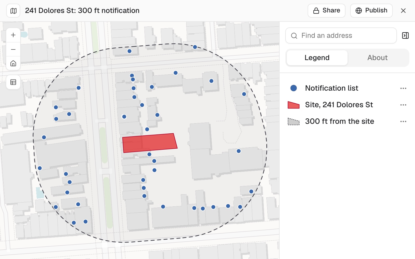 Example: the 300 ft line around the site at 241 Dolores St, San Francisco, in red, and the 439 addresses inside it that make the notification list. The units of one building share a point.
Worked through in the guide Neighbour notification list.
Draw a buffer: everything within a distance
Distance is in metres unless you give a unit. Name a column instead of a distance to give each place its own.
Draw a 500 m buffer around each school
Buffer each site by the distance in its consultation radius column
Draw rings at several distances
Ask for rings to get bands that do not overlap (0 to 1 km, 1 to 2 km). Otherwise each distance is a full disc from the place outwards.
Draw 1 km and 2 km rings around the site, as separate bands
Catchments by travel time
Who lives within a short drive of a store, which homes are within walking distance of a station, emergency cover from each station, delivery zones by drive time.
Straight line and travel can tell different stories. As the crow flies, a shop across a river or a motorway counts as near. Along roads and paths, it may be a long way round. For anything about who can actually get there, measure by travel.
Travel follows OpenStreetMap roads and paths. Drive times use ordinary road speeds with no traffic, at any time of day: not rush hour, blue-light driving or your service's own run times. For emergency cover, read them as a cautious estimate.
Lines and areas start from their centre. A catchment around a park or a district is drawn from its middle.
It tells you the cost first. Routing uses part of your allowance, and a catchment or a nearest search for every place in a large dataset adds up. Before a large job Mapstack says what share of your allowance it will use and what it will run, such as travel areas around 1,624 places, and waits. Select Go ahead to run it or Don't run it to stop; if you stop, nothing more is run. A cutoff, the nearest few, or straight-line distance keeps a job small. See Your allowance.
What falls in each band, by name. Ask which towns or postcode areas sit in each travel-time band, and you get them listed. Where an area lies across two bands, you get the share of it in each.
Draw a drive-time or walk-time catchment
Say how people travel: drive, truck, cycle or walk. Without it, Mapstack draws drive times.
Draw the 10-minute drive-time catchment around each of our stores
Draw several time bands at once
Each band is drawn as its own ring (5 to 10 minutes, 10 to 15) unless you ask for full areas from zero.
Show the areas within 5, 10 and 15 minutes' walk of each station
Measure a distance along roads and paths
A travel distance follows the network, not a straight line.
Draw the area within 5 km by bike of each school
Overlapping areas
Overlaps count for each. A place inside two buffers belongs to both, and where two of your places are close together, something between them counts for both. That is right for what each can reach. Ask for one combined area when you want each thing counted once.
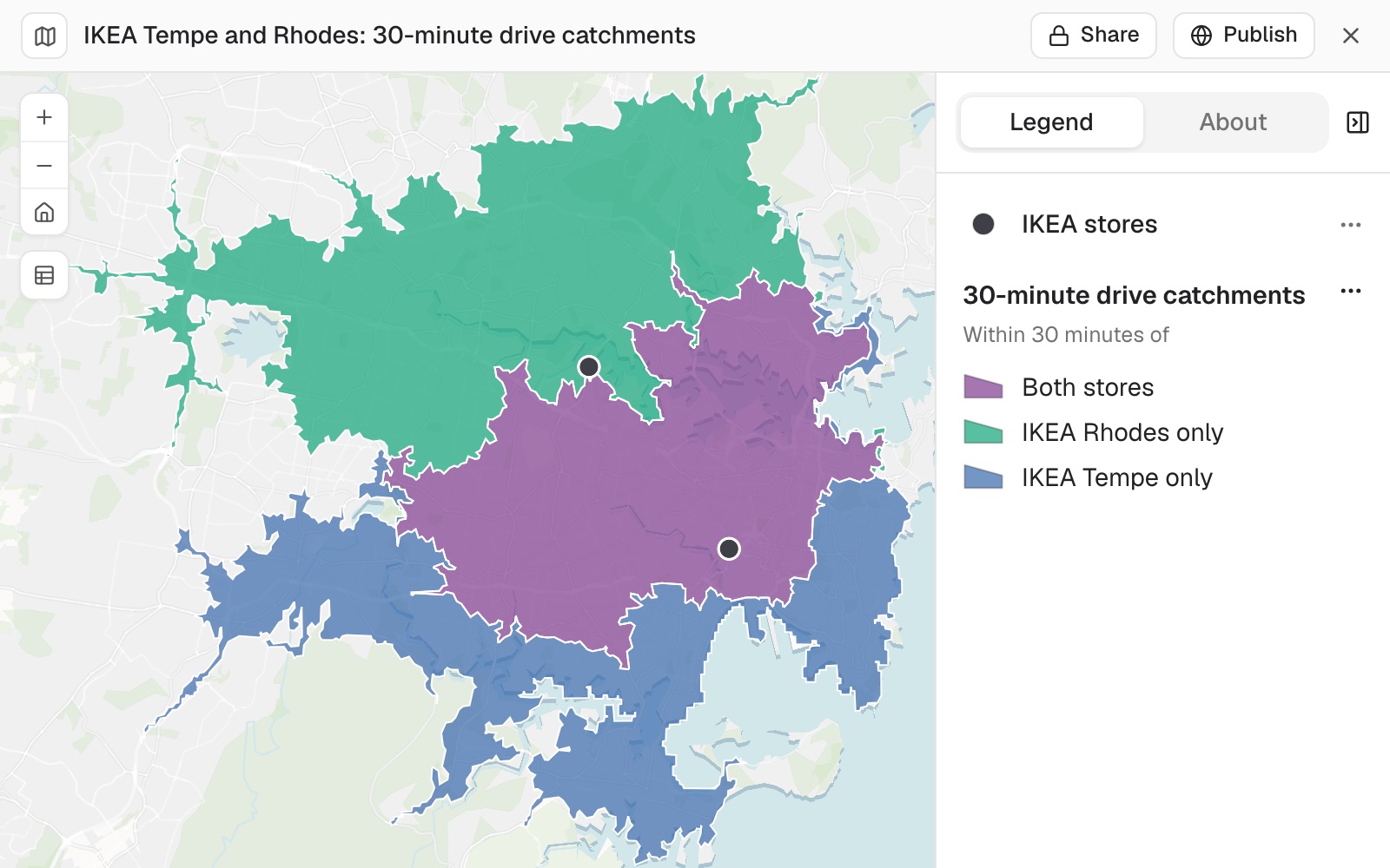 Example: the 30-minute drive catchments of IKEA Rhodes (green) and IKEA Tempe (blue) in Sydney, with the area within 30 minutes of both in purple. About 1.29 million people live in it, and count for both stores.
Worked through in the guide Compare two catchments.
Several people's areas at once. With an area for each of several reps, every customer can be marked with who reaches it: one rep, several or nobody. Move a base, and Mapstack works it all out again and sets it beside the first answer.
Draw one combined area
Overlapping buffers or catchments are merged into one area per distance or band, so anything inside is counted once.
Draw one combined area within 500 m of any of the schools
Draw one combined area within a 10-minute walk of any of these stations
The nearest place
The nearest branch and its distance added to every customer record, the closest three hospitals to each town.
Bring a second dataset to measure to, such as customers, hospitals or competitors. If you do not have one, Mapstack can fetch places such as shops or schools: see Data Mapstack can find for you. You get your places with their nearest, its rank and how far, and a line for each pair.
It draws the routes. When the nearest is found by travel, the line joining each pair follows the route.
The nearest in the same list. Ask for each branch's nearest other branch, and the list is searched against itself.
Find the nearest … to each place
Mapstack measures by drive time unless you say "as the crow flies", "straight line", "walk" or "by road distance". It can find the nearest one or the nearest few, and leave out anything beyond a cutoff. GIS people call this closest facility.
Find the nearest hospital to each of these towns by drive time
For each customer, find the three closest stores as the crow flies, in kilometres
Which station is nearest to each home on foot, within 20 minutes?
Add the nearest branch and the drive distance to it as new columns on every customer
Travel times between two lists
How far each customer travels to each of your stores, and which of two candidate sites more customers can reach quickly. You get one row for each origin and destination, with the travel time and distance.
Every pair is timed unless you limit it. With no limit, a travel time matrix times each origin to each destination, so the job grows with origins times destinations.
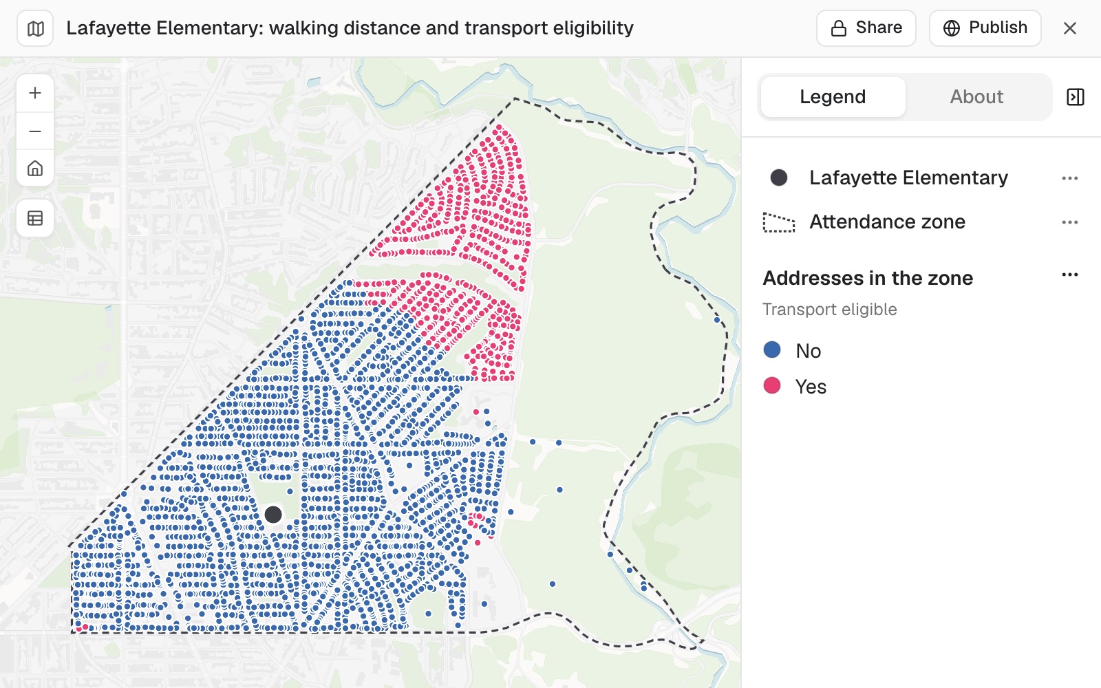 Example: the 3,664 addresses in the Lafayette Elementary School zone in Washington, DC, by their walk to the school. The 639 homes more than a mile's walk away qualify for transport (pink); the rest do not (blue).
Worked through in the guide School transport eligibility.
Time every journey between two lists
The time and distance by road or path for every pairing: each customer to each store, each town to each warehouse. GIS people call it an origin-destination (OD) cost matrix. Keep each origin's nearest few, or leave out pairs beyond a time, when only the closest matter.
How long does it take to drive from each customer to each of our 4 stores?
For each town, give the drive time to its 3 nearest warehouses
Give me walk times from each school to every library within 30 minutes
Keep the customer-to-store drive times as a dataset
What and who is near each place
Competitors within 1 km of each store, licensed premises within 400 m of each school, shops, stops and parks near each of three offices. Name any columns to total, if you want more than a count. You get your places with the counts as columns, or the rings and travel areas themselves.
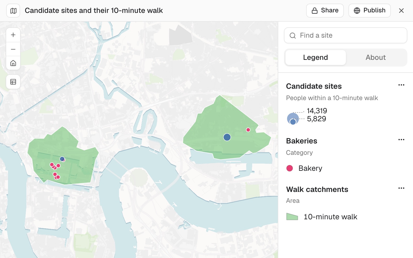 Example: two of five candidate sites in east London, Canary Wharf and Custom House, each with its 10-minute walk and sized by the people living inside it, 5,829 at Canary Wharf and 10,557 at Custom House, with the bakeries inside each walk.
Worked through in the guide Where to open the next site.
It writes out the method. Asked for the share of residents within a 400 m walk of a bus stop in each of Liverpool's wards, Mapstack set out every step: which stops it kept, the population figures it fetched and their date, the walking areas it drew on OpenStreetMap paths, and how it added them up. The whole job is in the guide Walking access by area.
It makes judgement calls and says so. In the same job it kept bus stops just outside the city boundary, so people living near the edge were counted as having access. Check calls like this against what you meant, and ask for the other way if you disagree.
Count what lies near each place
For each of your places, Mapstack counts and totals what lies within a distance or a travel time. Each distance gives its own band. Name a category column to count each kind separately. GIS people call this summarise nearby.
How many competitors are within 1 km of each of our stores?
How many pupils live within 500 m and within 1 km of each school?
How many incidents were there within a 10-minute walk of each station?
Within a 10-minute walk of each candidate office, count the cafés, shops and bus stops separately
Give me the 1 km rings as a dataset, with the counts on them
Count who lives within reach
Mapstack fetches official population figures itself and shares them onto the catchments. See Count and summarise by area for how.
How many people live within a 10-minute drive of each store?
Measure from a named place
A name can mean more than one place. There is a King's Cross in London and another in Sydney, and a Victoria station in many cities. The lookup picks the best match it finds and, like a person reading the name without context, it can pick another one. The town, and the country if it is not obvious, settle it. If the place is already in one of your datasets, Mapstack uses that and does not look it up. It never writes in a position from memory: if the lookup does not find a place, Mapstack says so.
Measure from a place you can name
You do not need a dataset that holds the place, or its coordinates. Mapstack looks the name up to find where it is (geocoding) and measures from there. Give the name in full, with the town.
Which of these cafés are within a 10-minute walk of King's Cross station, London?
How many of our customers live within 5 km of each of Manchester Piccadilly, Leeds and Sheffield stations?
Which of our depots is nearest to 10 Downing Street, London?
Reference
| How "near" is measured | |
|---|---|
| Straight line | As the crow flies, measured on the ground (geodesic) |
| Drive | By car on roads, with no live traffic |
| Truck | By road, for trucks |
| Cycle | By bike |
| Walk | On foot, on paths and streets |
| Setting | If you don't say |
|---|---|
| Buffer distance unit | Metres |
| Buffer shape | A full disc for each distance, one area per place |
| How catchments, the nearest and travel times are measured | Drive |
| Catchment bands | 5, 10 and 15 minutes, as separate rings |
| Catchment unit | Minutes. Also hours or seconds; kilometres, miles or metres |
| How many nearest | 1 |
| Rank the nearest by | Travel time |
| Straight-line unit for the nearest | Miles |
| Route lines for the nearest | Drawn |
| Travel time matrix | Every origin to every destination |
| How the method works | |
|---|---|
| Roads and speeds | OpenStreetMap roads and paths, at ordinary road speeds, with no traffic at any time of day |
| Longest travel time | 120 minutes |
| Longest travel distance | 200 km |
| Named places looked up in one step | 1 to 50 |
| Nearest few in a travel time matrix | Each origin is routed to its nearest candidates in a straight line (three times the number you ask for, and at least 10), and the nearest by travel time are kept from those |
| Very large sets of trips | Each place is timed along the roads to about its 15 nearest destinations. The farther pairs are estimated from the straight-line distance at the typical speed of the timed trips, plus 15%, and flagged as estimated |
| Very large results | See Sizes and limits |
On a Viewer seat you can ask for buffers, the nearest and what lies nearby, measured in straight lines, as answers in the chat. Catchments, travel time matrices and looking up named places need a Free, Creator or Creator Max seat.
What it can't do
- Use public transport.
- Use live traffic or a time of day.
- Reach beyond 120 minutes or 200 km by travel.
- Measure from a place the lookup cannot find. It never guesses a position.
Common questions
Should I use a buffer or a catchment?
A buffer for a fixed zone, such as a consultation area or an exclusion zone. A catchment for who can actually get there, because it follows roads and paths. To see the difference, ask for both: 'Count within 1 km in a straight line as well'.
Can it use buses, trains or rush-hour traffic?
No. Travel is by car, truck, bike or on foot, at ordinary road speeds with no traffic. For emergency cover, read drive times as a cautious estimate.
What unit is the distance in?
Buffers are in metres and the nearest, in a straight line, in miles, unless you say otherwise. Give the unit: 'Draw a 2 km buffer around each school', 'the three closest stores as the crow flies, in kilometres'.
How do I make sure it uses the right King's Cross?
Give the town and the country: 'King's Cross station, London, UK'. A name can mean more than one place, so distances far from what you expect usually mean it matched a place of the same name elsewhere.
How do I keep a big job small?
Limit what is routed. Ask for a cutoff ('only pairs within 30 minutes'), each origin's nearest few ('each customer's 3 nearest stores'), or straight-line distance. Before a large job Mapstack says what share of your allowance it will use and waits for your go-ahead.