

Make a neighbour notification list for a site
Select every address within a set distance of a site and get a mailing list to download, with a map of the site, the radius and the addresses for the case file.
Best for
Planning officers, planning consultants and project managers who have to tell the neighbours about a proposal: a planning application, street works, a new mast. You end up with a mailing list of every address within the distance your rules set, ready for a mail merge, and a map of the site, the radius and the addresses for the case file.
The example in this guide is real public data from San Francisco. The site is the parcel for planning application 2026-003165PRJ, a new eight-unit building at 241 Dolores St, taken from the city's parcel map (DataSF) as a GeoJSON file. The addresses are the city's Enterprise Addressing System address points (DataSF): 4,146 points within 400 m of the site, one for each address and each unit, with street, house number, unit, ZIP code and coordinates. With your own site and address layer, keep the shape of the asks and change the words.
What you need
- The site, as a GIS file of its boundary (GeoJSON, shapefile, GeoPackage and the like). The red line from the application is best: the distance is measured from its edge.
- The addresses, as points: a spreadsheet with coordinates or a GIS file. Mapstack does not supply address or ownership records, so bring your own, such as your council's address gazetteer or a city's open address points. Take a generous area around the site; Mapstack does the selection.
- A Free, Creator or Creator Max seat.
Before you start
- Say your rule exactly. The distance, whether it is measured from the site's boundary or its centre, and whether the site's own addresses are on the list. Notification rules differ by authority, and Mapstack follows what you state.
- Say what each row is. One row per address with unit numbers, or one per building: these give very different counts.
The prompt
Two files attached: the site boundary for planning application 2026-003165PRJ at 241 Dolores St, San Francisco (block 3556, lot 032), and the city's address points (Enterprise Addressing System) around it. I need the neighbour notification list: every address point within 300 feet of the site boundary, not counting the site itself, as a mailing list I can download, one row per address with unit numbers. And a map for the case file showing the site, the 300 ft buffer and the addresses on the list. Tell me how many addresses and how many buildings are on the list.
What to expect
Your files become datasets
Both files are kept as datasets you can open and check: the site as one area, the addresses as points.
Mapstack draws the buffer and selects the addresses
A buffer is the area within a set distance of something. Mapstack draws it around the site boundary, measuring true distance on the ground, and selects the address points inside it. The list is a new dataset, and the buffer is kept as a dataset of its own. To leave the site off, Mapstack tests every point against the site boundary and names the ones it takes off: in the example the site's own six, 241, 243, 245, 247, 249 and 251 Dolores St. Then it gives the totals you asked for: in the example, 439 addresses in 79 buildings, counting a building as one house number on one street.
It makes the map for the case file
The map shows the site, the buffer and the addresses, with a legend, a scale bar in feet and a search box for addresses. Selecting a point shows its address, unit and ZIP code.
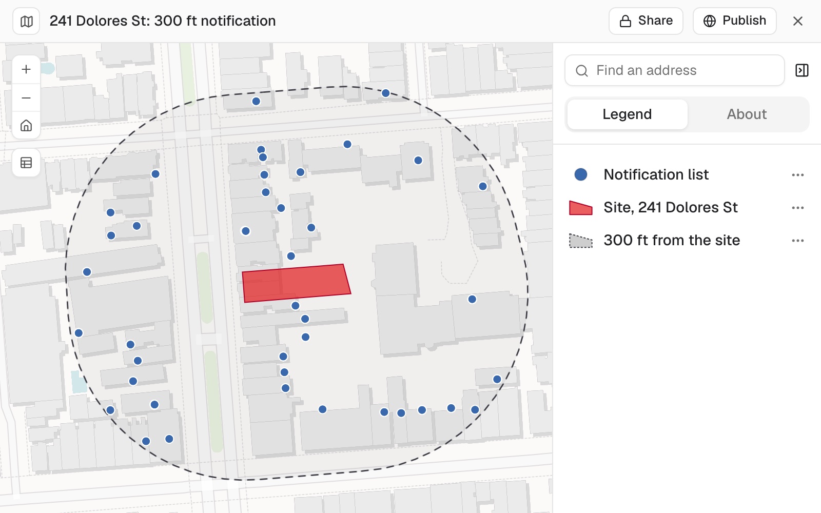 Example: the 300 ft notification map for 241 Dolores St, with the site in red, the 300 ft line dashed and the 439 addresses on the list. The units of one building share a point.
You check the edges of the list
Check the list the way you would a colleague's before the letters go: the addresses on the site itself, and the ones just inside or outside the line. In address data, every address on a lot is often a point at the same spot, so search the map for the site's house numbers, and for a neighbour you know should be there.
Ask for the distance of each address from the site boundary to see the edges of the list. In the example the nearest address on it is 13 feet from the site and the farthest 298 feet, inside the 300 ft line.
You take the list away
Ask for the columns and order your letters need; the ask under Make it your own below is a good start.
To take the list away, open the dataset and select Download, then Spreadsheet for a .csv that opens in Excel or a mail-merge tool. See Download and export.
Make it your own
Add a column addressee set to Current Occupant for the mail merge, keep the unit numbers as text, and sort the list by street, then house number, then unit.
Common questions
How do I make sure the site's own addresses are off the list?
Ask: "Take off every address point that falls inside the site boundary, and tell me which ones came off." Then search the map for the site's house numbers. Address data often puts every address on a lot at the same spot, so these are the rows to check first.
Why are there so many more addresses than buildings?
A row is whatever you say it is. One row per address with unit numbers counts every unit: in the example, 439 addresses in 79 buildings. Ask for the totals both ways, and say whether the distance is measured from the site boundary or its centre.
What if a neighbour isn't on the list?
The list is only as complete as your address layer. Check that the file covers the whole area around the site, and attach a wider extract if it does not.
Can Mapstack supply the addresses or the owners?
No. Bring your own address points, such as your council's address gazetteer or a city's open address points. Take a generous area around the site; Mapstack does the selection.