

Data Mapstack can find for you
Ask for businesses, census figures, boundaries or an open dataset you do not have, or give a link, and Mapstack brings it in as a dataset.
Most work puts your own data beside data someone else publishes: the businesses in a town, the population of each area, ward boundaries, flood zones, school sites. You do not need to have it. Ask Mapstack, and it finds it and brings it into your session as a dataset, the same as a file you attach, ready to map, join or analyse.
You say what you want in your own words. Mapstack knows where each kind of data lives: places and businesses from Overture Maps, an open dataset of places around the world; population and other measures from each country's official statistics; boundaries from the Community Library's checked sets; anything else from the Community Library or the open web. Or give it a link and it fetches that. The asks on this page are examples of the kind of thing to say.
- Who can use it
- Free, Creator and Creator Max
- You provide
- What you want and where, or a link
- You get
- A dataset, checked against what you asked for, or the answer to your question
Ask for data in your own words
Say two things: what you want (a brand, a kind of place, a measure, a kind of area, or a subject) and the place (a city, county, state or country). Add the country when the name is shared ("Birmingham, UK", not "Birmingham").
It works inside the place you name. For places or statistics in a city, county, state or country, Mapstack first finds that place's outline and keeps the work inside it. If more than one place has the name (Birmingham in England and in Alabama), it lists them and you choose: adding the country ("Leeds, UK") saves the question. The outline follows the coast; for a request about the sea, such as fishing grounds or offshore wind, Mapstack can keep the place's territorial waters, 12 nautical miles out. The outline is a working shape, with a name and nothing else: the areas inside a place, such as its wards, come with the data that fills them, or as a set of boundaries you ask for.
It asks what you mean when your words could mean two things. A supermarket chain's food shops only, or its other businesses too. A city proper or its wider metro area. One row per school or one value per district. Mapstack asks before it searches. Once a search starts, it runs to the end.
Each search brings in one dataset, and one ask can hold several searches. Ask for the pieces of a picture together (the areas, the places inside them, the roads, the figures that fill them) and Mapstack searches for each and hands back a dataset for each, every one with its own source. They arrive in your session and your Library. Open one from its card in the conversation: its Details show what it holds, where it came from and how it was made. From there it behaves like data you brought.
A question gets an answer. When you ask for a figure, a count or a ranking, such as "How many supermarkets are there in Bristol?", Mapstack fetches the data it needs, works out the answer and gives it to you in the conversation. The data it used stays out of your session and your Library. To look at it, map it or keep it, ask: Mapstack brings it in as a dataset.
Finding data uses part of your allowance. See Your allowance.
Businesses and places
A list to act on: every gym in a city to sell to, the pharmacies near each of your sites, where one brand outnumbers another.
Mapstack judges every listing. A database of places is built from many sources, and its categories are uneven: the same kind of business can sit under different headings, and a brand's name can turn up inside another business's name. So Mapstack reads each listing (its name, category, website and address) against what you asked for and keeps the ones that fit, much as you would going down a directory. Kinds that are the same thing, such as coffee shops and cafes, are taken together. Say what counts and what to leave out, if it is not obvious.
- Every place carries a confidence. High means the listing plainly fits, medium that it fits on a closer look, low that Mapstack was unsure but leaning yes and kept it for you to decide. Look at the low ones first.
- Duplicates are merged or flagged. Listings judged to be the same place become one. Listings that only might be the same place are kept and marked as a possible duplicate group, for you to decide.
- It tells you what it left out, and why, such as an independent shop when you asked for a chain, and offers to put back anything you want.
- It never offers a related kind instead. If there are no taxi ranks, you do not get taxi companies.
Each place is a point, with, where Overture Maps holds them, a name, brand, street address, city, state, postcode, country, category, website, phone, email and social link, plus its confidence and any possible duplicate group. With it, Mapstack tells you how many places it found, the categories and brands it used, how many sit at each confidence, what it left out, and which Overture Maps release the data came from.
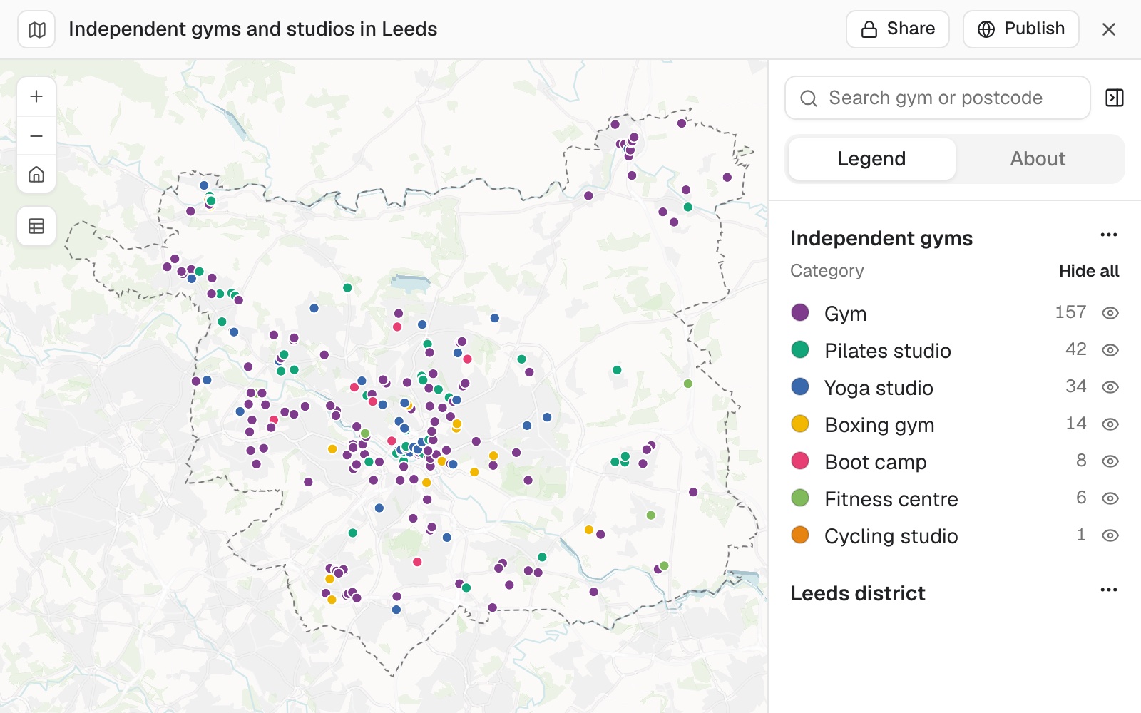 Example: 262 independent gyms and studios in the Leeds district, coloured by category: 157 gyms, 42 Pilates studios, 34 yoga studios and 29 in four smaller categories.
If a place is missing, has closed, or has a detail out of date, correct the row in the dataset: see Edit your data.
Find a chain, or the brands of one kind of business
Name the brand, or the kind of business, and an area. Asked for the brands of a kind, you get every branded place of that kind in one dataset, each under its brand, so the map can colour them by brand.
Find every Starbucks in Seattle
Which hotel brands are in Manchester, UK? Put them on a map coloured by brand
Find every place of a kind: points of interest
Say what counts. Mapstack judges every listing against what you describe, so a fuller description gets a better list. Places closed for good are left out unless you ask for them.
Find me every gym in Leeds, UK
Find the pharmacies in Leeds, UK, including pharmacy counters inside supermarkets
Find the cafes in Lyon, France, but not the bakeries
Find the cafes in Lyon, France. Include the ones that have closed for good
Population and census figures
Context for your own data, such as how many people live near each store. Each column is a statistic as the office released it, and the dataset comes with a note of the release, year and level.
To put census figures onto your own areas or catchments, see Count and summarise by area.
Get population and census figures by area
Name a measure in your own words and a place. You get the areas inside the place, each with the figures as the statistics office published them. How to name the level and year, and what Mapstack tells you about the figures: Get census and official statistics.
How many people aged 18 to 24 live in each part of Leeds, UK?
Get household income by census tract for Denver, Colorado
Boundaries: wards, counties and census areas
Areas to report by: shading a table of figures by county, reporting your own records by ward, checking everything you mapped sits inside the area it should.
Boundaries for a table come from the best set Mapstack can find, in this order.
- The Community Library's boundary sets. These have been checked, and include areas that are not tiers of government: constituencies, wards and census areas. A table covering the whole world is matched to one set of all countries.
- A live open source, only when the Library has nothing that fits and your table is one tier of one country's government (its provinces, states or districts). The shapes come from geoBoundaries or the UN OCHA common operational datasets, whichever has a number of areas closer to your table's, and carry a note that they were fetched live and not checked by the Library.
- A boundary file in your session, one you attached or one a search found. For wards, postcode areas or census areas the Library does not hold, this is the way: ask a search to find the set, or attach your own.
You get a dataset of shapes with your columns on each, and an account of how many of your areas matched.
The edition matters. Boundaries are redrawn, and codes and names change with them, so figures published for one year's areas belong on that year's boundaries. When some rows of a table do not match, Mapstack lists them: a run of unmatched names or codes is often the sign of a different edition or level.
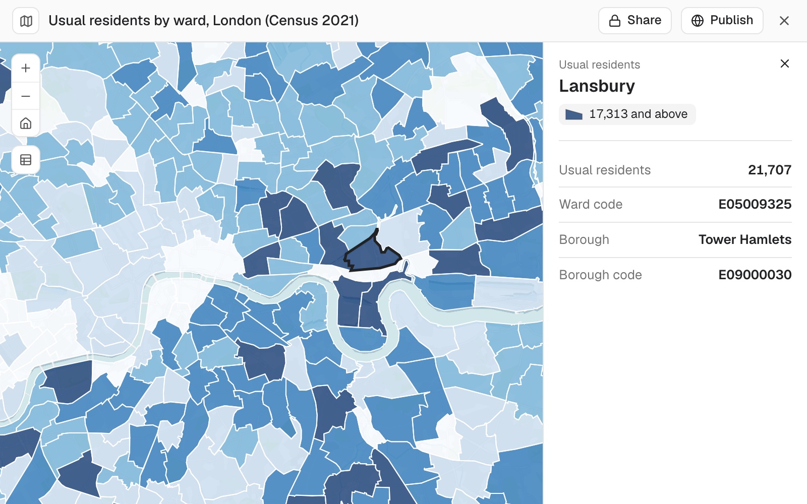 Example: London's 2022 wards, the edition the ONS published Census 2021 ward figures for, coloured by usual residents, with Lansbury in Tower Hamlets selected: ward code E05009325, borough code E09000030.
A search looks for whoever publishes the set. For areas no checked set holds (a council's own wards or neighbourhoods, postcode districts, a conservation area, US census blocks or ZIP code areas), Mapstack goes to the publisher: a national statistics or census service, a state mapping office, a regional body, or the council's own open-data service. The dataset names the source and the edition it used.
It never guesses a shape. When no boundary set fits a table, it describes the boundaries that would, and you can attach them or take one point per area.
Get official boundaries: wards, counties, census areas
Ask for a set of boundaries as a dataset, naming the year if it matters. Or attach a table with one row per area and a column of names or codes: Mapstack finds the boundaries to draw it on (more in Map a spreadsheet). It also fetches an area's outline itself to check your data against it.
Find the electoral ward boundaries for Birmingham, UK
Map this spreadsheet of sales by US state as areas, not points
Are any of the food businesses placed outside the Liverpool council area?
Open datasets on any subject
Flood risk areas to check your sites against, reported incidents to count by area, and anything else someone publishes: land parcels and assessments, road networks, protected areas, published election results, a city's own sea-level-rise scenarios.
It looks again when the first answer is thin. If a places search returns far fewer than the place should hold, Mapstack goes on to open data for the fuller set and says which it used. Where what you asked for is not the kind of thing a places search carries at all (every bus stop, park boundaries as areas), it says so before it runs, names where the data would come from, and fetches it when you say yes.
If a file you attached will not open, it looks for the publisher's own copy of the same layer, and tries the formats that publisher offers until one reads.
Some data is only worth having as it stands now: which warnings are out, where a fire is burning, what a river gauge is reading. For these Mapstack can query a public service directly instead of looking for a published file, so the answer is today's. The dataset carries the service and the moment it was read on its Details. What the service holds is the limit: a feed of current records cannot tell you about last month.
The Community Library first, then the open web. The Community Library is Mapstack's public catalogue of datasets. When an entry fits, Mapstack copies it into your workspace as your own copy; when the nearest covers less than you asked for (England when you asked for the UK), it adds it and tells you what is missing. Only when the Library has nothing on the subject does it go to the open web, preferring official sources: open-data portals, files published by statistics offices, open boundary sets, and published lists of facilities, sites or events.
It reads a file before it trusts it. Open data is published by many bodies, under many names, at many levels and editions, and a file's title does not always match what is in it. So Mapstack checks that the file holds what it claims, then checks it against what you asked for: the place, the level, the number of areas, the format and the year. A file for another place, level, year or kind of thing is named as a near miss, with the gap, and is not used. If it will do, say so. When the file it brings in departs from what you stated (a workbook when you named CSV, say), the departure is listed. A different measure is never swapped in.
What a search brings in is one checked file, ready to map, join or analyse: a file that is ready to map, or a table with a location to join on (an area code or name, or coordinates). Check the year before you rely on it. A list of addresses, an old-format .xls file, or a table that repeats each area by a category such as age band, is something to download and attach yourself: Mapstack looks up addresses from a file you attach. See Map a spreadsheet.
Find an open dataset on a subject
Say three things: what the data is about, the place, and what one row is. "One row per incident" and "one row per ward" are different datasets on the same subject. To see what exists first, ask.
Find reported crime incidents for Chicago in 2023, one row per incident
Find the flood risk areas for England
Is there a dataset of flood risk areas for England?
Use data as it stands now
Which flood warnings are active in Florida right now?
Get the current wildfire perimeters and check which of our sites they reach
Find the river level stations within 25 km of this catchment and their status
Hold a search to a level, a year or a source
Anything you name is a requirement, so name it only if it matters: the level ("by county", "NUTS 2"), the year, the number of areas ("all 254 counties"), the format, or the source ("an official source", a named publisher). A file that misses it is reported to you, not used.
Find median rent by county for Texas, from an official source
Find the electoral ward boundaries for Birmingham, UK, as they were in 2022
Data from a link you have
A link is a requirement. Given a link, Mapstack fetches that address and nothing else, with no search first, and checks the file in the same way as a file it found. It fetches data files: it does not read an article or a report for you.
If the file is in your Google Drive, OneDrive or Dropbox, connect it instead: see Use files from Google Drive, OneDrive or Dropbox.
Bring in data from a link you have
Paste the link and say what the data is. The link can be the file itself or the dataset's page on an open-data portal: Mapstack finds the download behind it. If the page offers several releases, say which one. The links below are placeholders.
Use the school locations at https://data.example.org/schools-2024.csv and map them
Bring in the hospital list from this page, the 2023 release: https://opendata.example.org/dataset/hospitals
Data you download yourself
Some data it hands to you. When a file sits behind an export form, or exists only as a table on a web page, Mapstack gives you the exact page and the steps to download it yourself. Then upload the file.
When nothing fits, it says what it tried and suggests the next step: relax a requirement, give it a link, or attach a file you have. It never makes data up.
Where in the world, and what you bring yourself
Most of it works anywhere. Address lookup, travel times and routes, and places and businesses from Overture Maps cover the whole world, though Overture Maps lists more in some countries than others. Boundaries for one tier of a country's government can come from the open sources above, for any country.
Census figures depend on the country. Mapstack holds official statistics for most of Europe and North America, Australia and New Zealand, and a selection of other countries. Ask for a measure in the place you want and it tells you whether it holds it: see Get census and official statistics.
Some data it does not hold, so you bring it. Footfall, consumer spending, mobile coverage, rents and your own sales are not among the data Mapstack holds. Attach them as a table by area or a list of places, or, where someone publishes them openly (a regulator's coverage figures, say), ask Mapstack to find the dataset. From then on they map, join and analyse like anything else.
Reference
| Places | Overture Maps only. One release is used, and the result names it. Categories are Overture Maps' own, read from those used in your area. Coverage is not the same everywhere |
| Closed places | Places closed for good are left out unless you ask. Places closed for a while are kept |
| Census and statistics | Each country's official statistics. See Get census and official statistics |
| Area of a places or statistics request | One city, county, state or country |
| Boundary sets | The Community Library's checked sets; geoBoundaries and the UN OCHA common operational datasets, live, for one tier of one country's government; or a search for the body that publishes the set |
| Open datasets | The Community Library, then the open web, including a publisher's own data service |
| Map-ready files from a search or link | GeoJSON, Shapefile, GeoPackage, KML or KMZ |
| Tables from a search or link | CSV or Excel workbook (.xlsx), with a location to join on: an area code or name, or coordinates |
| Portals it can resolve to a download | CKAN, Socrata, ArcGIS, OpenDataSoft, Eurostat and udata |
| Files per search | One. An ask can hold several searches |
Each search has a fixed allowance of web searches and page fetches. When it is spent, Mapstack stops and tells you what it tried. When a places search finds too many places, nothing is made, and Mapstack asks you to narrow the area or the request. Very large files: see Sizes and limits.
What the Community Library holds, including which boundary sets, changes as people publish to it, so this page does not list it.
What it can't do
- Promise a list of places is complete or current. Overture Maps can miss places, and can still list places that have closed.
- Use place results from map providers, or individual property listings.
- Read a web page, an article or a report for you. It fetches data files.
- Guess the shape of an area when no boundary set fits.
- Find data from a Viewer seat.
Common questions
Is this every gym in the city?
It is every gym Overture Maps lists there that Mapstack judged to be one. Open data like this misses some places and keeps some that have closed, more in some countries and categories than others. For a list you will act on, look at the low-confidence places and ask what was left out.
Can I map my competitors against my own stores?
Yes. Attach your list of stores, ask for the competitor brand in the same area, and ask for both on one map. To count what lies near each store, see Find who and what is within reach.
Which boundaries do you have for my country?
It changes as sets are added, so ask: "Is there a dataset of ward boundaries for Birmingham, UK?" You can always attach your own boundary file, and Mapstack matches a table to it.
The file it found is close, but not what I asked for. Can I use it?
Yes, say it will do. Or ask again with a different requirement, such as the year: "Find the electoral ward boundaries for Birmingham, UK, as they were in 2022."
Can I use the data however I like?
That depends on its licence, which is set by whoever published it, not by Mapstack. Check the source's terms before you publish or share what you make with it.