

Upload a file
Attach a spreadsheet, GIS file, imagery or 3D scan to a message, or paste a few rows, say what you want, and Mapstack reads it in and gets on with the job.
Every file comes in the same way: attach it to a message and say what you want done with it. Mapstack works out what kind of file it is and reads it into one of three things:
- a dataset, from a spreadsheet or a GIS file: records you can map, query and edit;
- imagery, from a satellite or aerial image, an elevation model or another grid;
- a scene, from a LiDAR point cloud or a 3D model.
From then on it is in your Library, ready for any session. There is nothing to save. A customer list, an export from another system, a council's boundary layer, a drone survey, a LiDAR scan: most jobs start here, and most go on in the same message: the map, the count, the comparison.
- Who can use it
- Free, Creator and Creator Max. Imagery and scenes need Creator or Creator Max.
- You provide
- A file, or a few pasted rows, and what you want done with it
- You get
- A dataset, imagery or a scene, and whatever you asked for next
Attach a file and say what you want
It reads the file before it acts. Mapstack works out what the file holds (rows of addresses, coordinates or area names; GIS layers; image bands; points in 3D) and reads it the way that kind of data needs. How each kind is read is on its own page: spreadsheets, imagery and LiDAR and 3D models. A spreadsheet needs something that says where each row is: an address, coordinates, or an area name or code. Then say what you want done. Even "put it on a map" is enough.
It asks only when the choice is yours. Which sheet of a workbook, which layer of a GIS file, which coordinate system when two fit, which shapes to keep when a layer mixes points, lines and areas and no one kind makes up 95% or more, whether a table of area names should be drawn as areas or as points. Every question includes None of these. Everything else it decides, and tells you what it did.
A card for each thing made. Each dataset, imagery or scene gets a card in the conversation: open it to check what came in. Imagery and scenes are converted once in the background, and their card updates when they are ready. If you asked for more in the same message (a map, a count, a comparison), that follows. To get data back out as a GeoPackage, GeoJSON or CSV, see Download and export.
On our own walk through the product, two public files were attached in one message: Merseyside's bus stops as a CSV (from the Department for Transport's NaPTAN register) and Liverpool's 64 wards as GeoJSON (from the ONS). Each became a dataset, and the same request counted the stops in each ward and shaded the wards by the count. The asks in this section fit those files; the asks elsewhere on the page are examples of the kind of thing to say.
Bring a file in and use it straight away
Attach the file and say what you want in the same message. Mapstack reads the file first, then does what you asked with it. You do not say what kind of file it is.
Count the active bus stops in each ward and shade the wards by the count
Bring in several files at once
Attach them together. Each one becomes its own dataset, and your request can use them all.
Map the bus stops and the ward boundaries together, with the wards as outlines
Use something you brought in before
You do not upload a file twice. Name what is in your Library, or choose Add from library from the + in the message box.
Put the Liverpool wards from my library on top
Shapefiles, GeoPackages and other GIS files
A file that comes in parts needs all its parts: a shapefile's parts picked together, or zipped, with its .prj (that is what declares the coordinate system); a File Geodatabase or MapInfo TAB zipped; an image with its .prj or world file picked together, when its location is in the sidecar.
Anything it can open, it tries. The formats in the Reference table are the promised ones. Another GIS format is attempted; if it cannot be read, Mapstack says so and names its best guess at what the file is.
Bring in a shapefile, GeoPackage, GeoJSON or KML
A GIS file already holds shapes (points, lines or areas) and their attributes. For a shapefile, pick its parts together (.shp, .shx, .dbf, .prj, .cpg) and they are bundled into one zip in your browser, or attach them already zipped. Zip a File Geodatabase or MapInfo TAB before you attach it.
Show the conservation areas in this shapefile
Pick a layer from a file that holds several
A GeoPackage, File Geodatabase or zip can hold several layers. Name the one you want, and which shapes to keep if it mixes points, lines and areas. If you do not, Mapstack asks.
This zip is a file geodatabase. Map the parcels layer and keep only the polygons.
Coordinate systems
A wrong coordinate system puts every feature in the wrong place, so Mapstack settles a GIS file's system and shows its working. Each dataset says what system the file was in and how that was settled:
- Declared: the file states its system, and Mapstack uses it.
- Assumed: the file states none, and its numbers look like longitude and latitude, so WGS84 is assumed and reported as assumed.
- Checked from the location: the file states none (or one its numbers contradict), and the numbers look projected, in metres or feet. Mapstack tries the likely systems and keeps the one that puts the data inside that system's area of use. If two fit, it asks you. If none fits, the file is refused rather than placed in the wrong spot.
- Chosen by you: you named it.
Data is stored in longitude and latitude (WGS84), the system web maps use.
Say which coordinate system a file is in
When a file does not say, or what it says does not fit its numbers, tell Mapstack. An EPSG code is the surest way.
Map this file. It has no .prj, and the coordinates are British National Grid, EPSG:27700.
Repairs, and the account of each dataset
It repairs what it can prove, and says so. Shapes that cross themselves, curves (turned into short straight segments), single and multi-part shapes mixed in one layer, field names a dataset cannot use, garbled text (read again in another encoding), features with no shape, lines crossing the 180° meridian, and attributes hidden in KML descriptions. Each kind of fix is listed, with a count where there is one.
For a GIS file you are told, for each dataset, its name, how many records it has, its kind of shape, the area it covers, its coordinate system and how that was settled, and the fixes made.
A dataset's Details show what it holds: its records, its kind of shape, where it is, and every column with its type and statistics.
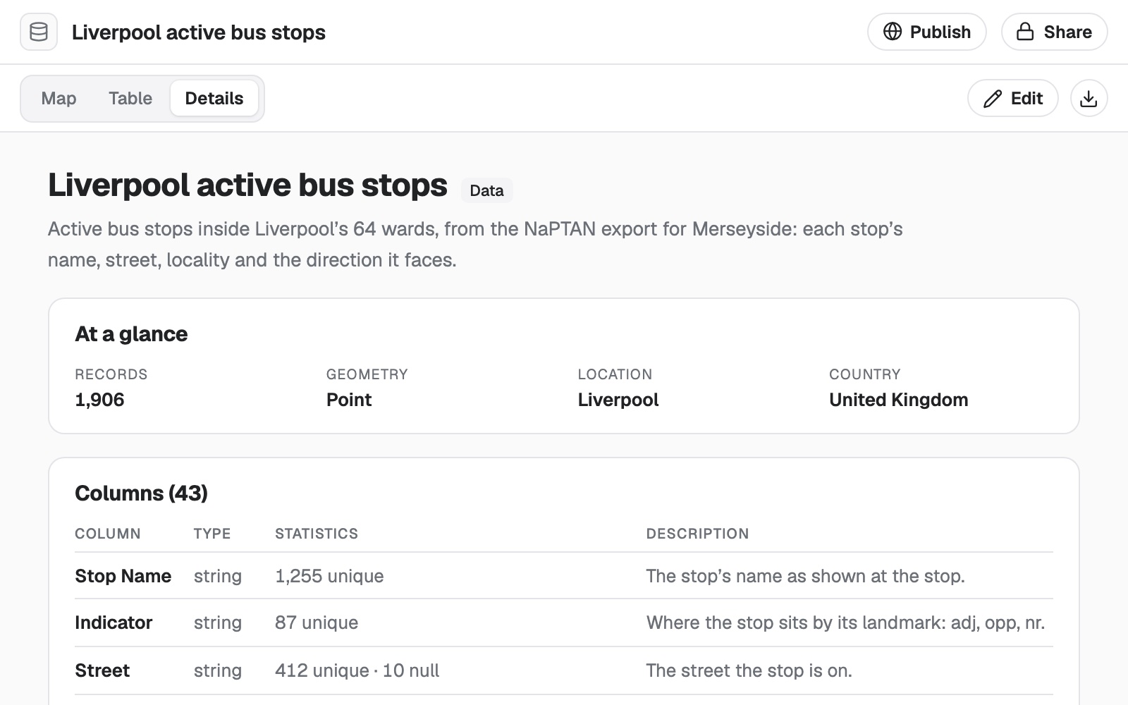 Example: the Details of a dataset made from the NaPTAN bus stop file: Liverpool's 1,906 active bus stops, as points, and the first of its 43 columns, each with its type, statistics and a description.
Paste rows instead of a file
Rows pasted with their heading row (at least two lines) are read like a spreadsheet. Pasted rows are kept exactly. Nothing is cleaned before they are saved, so what Mapstack reads is what you pasted. Tabs (what Excel and Google Sheets put on the clipboard), commas, semicolons and pipes are all recognised as separators.
Paste a few rows instead of a file
For a handful of rows there is no need to save a file. Copy them from Excel, Google Sheets or a CSV, with their heading row, paste them into your message and say what you want. Mapstack saves what you pasted, exactly as it is, as a CSV file in your session, and reads it as it reads any spreadsheet.
Here are our five depots with their postcodes. Put them on a map and label each one.
Map this table of visitor numbers by county as areas
Large files
Big files keep going. Imagery and scene files can run to gigabytes, so their upload shows progress and the time left, and you can cancel it. If the connection drops it pauses, and carries on from the parts already sent. After a page reload, pick the same file again and it continues. Spreadsheets and GIS files have a much smaller limit of their own: see Sizes and limits.
You hear straight away if a file will not go in, before anything uploads: a type it does not take, a file over the size limit, a 3D file with no location, or imagery or a scene on a Free seat. The message says why.
Your data arrives whole. A file is never trimmed to fit a limit, so a dataset always holds all of your file.
Reading files uses part of your allowance. See Your allowance.
Reference
Every kind of file
| Kind of file | Extensions | What you get | Seats |
|---|---|---|---|
| Spreadsheets | .csv, .xlsx, .xls | A dataset | Free, Creator, Creator Max |
| Pasted rows | Tab, comma, semicolon or pipe separated, with a heading row | A dataset | Free, Creator, Creator Max |
| GeoJSON, and line-delimited GeoJSON | .geojson, .json, .geojsonl, .ndjson | A dataset for each layer | Free, Creator, Creator Max |
| Shapefile | .zip, or .shp with .shx, .dbf, .prj and .cpg picked together | A dataset | Free, Creator, Creator Max |
| GeoPackage | .gpkg | A dataset for each layer | Free, Creator, Creator Max |
| KML and KMZ | .kml, .kmz | A dataset | Free, Creator, Creator Max |
| GPX | .gpx | A dataset | Free, Creator, Creator Max |
| File Geodatabase | .zip only | A dataset for each layer | Free, Creator, Creator Max |
| MapInfo TAB | .zip only | A dataset | Free, Creator, Creator Max |
| FlatGeobuf, TopoJSON, GML | .fgb, .topojson, .gml | A dataset | Free, Creator, Creator Max |
| GeoParquet | .parquet, .geoparquet | A dataset | Free, Creator, Creator Max |
| Imagery | .tif, .tiff, .geotiff, .jp2, .img, .asc, .dem, with sidecars .prj, .tfw, .tifw, .tiffw, .j2w, .wld | Imagery | Creator, Creator Max |
| Point clouds and 3D models | .las, .laz, .e57, .slpk, .3tz, .ifc, or a .zip of LAS or LAZ tiles | A scene | Creator, Creator Max |
The file picker also offers .tsv, .txt and .ods. Spreadsheets are read from .csv, .xlsx and .xls, so save those as CSV or Excel first.
GIS files
| Text encodings | UTF-8, Windows-1252, ISO-8859-1 |
| Coordinate systems checked for when the file does not say | EPSG:27700 (British National Grid), EPSG:9311 and EPSG:2163 (US National Atlas Equal Area), EPSG:3857 (Web Mercator), EPSG:4283 (GDA94) and EPSG:7844 (GDA2020). Any other system must be declared in the file or named by you |
Very large files: see Sizes and limits.
What it can't do
- Take time-series files: NetCDF, HDF or GRIB.
- Take 3D files that carry no location: glTF, GLB, OBJ, FBX, PLY, XYZ or PTS.
- Take CAD drawings (DWG, DXF), PDFs, ordinary pictures or web map services.
- Connect live to a database, a WMS or WFS service, or ArcGIS Online. Bring the layer as a file: see Take it into desktop GIS.
- Read a GIS file with no shapes in it.
- Take curved shapes it cannot turn into straight segments. Export the file again with curves converted.
- Guess a coordinate system it cannot check. Numbers that look like UTM metres with no zone it can confirm are refused rather than have a zone assumed.
- Split areas that cross the 180° meridian. They come through, with that stated.
- List every layer of some File Geodatabases. When it cannot, it reads the first layer and warns you.
- Take a MapInfo TAB or File Geodatabase that is not zipped.
- Treat a single pasted line as a table.
- Trim a file to fit a limit. It is refused whole.
- Take imagery or scenes on a Free seat.
- Take a file from a Viewer. A Viewer can open and ask about what is in the workspace, and cannot add to it.
Common questions
Can I upload a CAD drawing or a Google Sheet?
Not as they are. Export a CAD drawing as a GeoPackage or a zipped shapefile, and a Google Sheet as Excel or CSV, then attach that.
My shapefile is in several parts. Do I need to zip it?
No. Pick all the parts together, the .shp included, and they are zipped for you.
Does Mapstack keep my coordinate system?
Your data is converted to longitude and latitude (WGS84) to be stored and mapped, and Mapstack tells you which system it came in and how that was settled. If a dataset shows in the wrong place, name the right system and ask Mapstack to convert it: 'These are in British National Grid, EPSG:27700.'
Can I bring a file straight from Google Drive, OneDrive or Dropbox?
Yes, once the drive is connected. See Use files from Google Drive, OneDrive or Dropbox.
Is my original file changed?
No. What Mapstack makes is a new thing, read from your file.