

Clean up a messy file and hand it back in a format another GIS can open
Filter and tidy an export, find out why its points landed in the wrong place, keep a log of every change, and download the result for a GIS team.
Best for
Anyone handed an export that is not ready to use: a GIS officer fixing a colleague's file, a consultant tidying a client's register, anyone whose points showed up in the sea. You end up with a clean dataset on a map, a log of what was dropped and changed and why, and a file the next person's GIS can open.
The example in this guide is a real export: the Department for Education's register of schools (Get Information About Schools), cut to Manchester on 11 November 2026. It has 475 rows, open and closed schools together, with each location as British National Grid eastings and northings rather than latitude and longitude. Nine rows have no coordinates, and the phase of education reads "Not applicable" for special schools, independent schools and pupil referral units alike. Every ask below is written for that file. Results vary in the detail from one run to the next.
What you need
- The file, as a spreadsheet (.csv, .xlsx or .xls) or a GIS file. See Map a spreadsheet with coordinates and Upload a GIS file.
- To know what its coordinates are, if they are not latitude and longitude: say it in your ask, as "eastings and northings" or by the system's name or EPSG code.
- Any seat. Viewers can open the result but not change it.
Before you start
- Say what clean means for you. Which rows to keep, what to do with rows that have no location, and the exact values a field should end up with. Mapstack follows what you state and reports what it did; anything you leave open, it decides and tells you.
- Everything is kept in latitude and longitude. Mapstack converts other coordinate systems on the way in, so mixed files line up. Downloads are in latitude and longitude too (WGS 84, EPSG:4326).
The prompt
This is the DfE schools register export for Manchester. The locations are eastings and northings. Clean it up for me: open schools only, drop anything with no location and tell me how many you dropped and why, and put what's left on a map.
What to expect
Your rows are placed, and what cannot be placed is reported
Mapstack converts the eastings and northings to latitude and longitude and keeps the file as a dataset. Rows with no location are left out, not put at zero, and it tells you how many and why: in the example, 7 of the 475 rows had neither coordinates nor a postcode, all of them schools that closed between 1987 and 1997. Two open schools had no coordinates but did have a full address, and stayed in, placed from it.
It filters, and makes the map
Each cleaning step gives a dataset you can open and check. In the example the open-schools dataset holds 222 rows, which matches the register's count of schools marked Open. The other 244 closed schools went, and so did the two rows for a school becoming an academy next April, one marked open but proposed to close and one proposed to open; say so if you want rows like those kept. The map is coloured by the phase of education, with a search by school name.
You check where things landed
Look for points far from the rest: it is the quickest check that the coordinates were read the right way. In the example the furthest are about 10 km south of the others, in Wythenshawe, and they are right: Manchester's boundary runs south through Wythenshawe to the airport. A point far away is either a fact about the place like this, or a wrong coordinate; the row's address tells you which.
You find out why it went wrong elsewhere
A colleague mapped the original file in another tool and some schools ended up in the sea off Africa. Why would that happen, and is it sorted here?
Mapstack explains the cause and what it did differently. In the example: the other tool most likely read the empty coordinates as 0, 0, a point in the Atlantic off West Africa that GIS people call Null Island, or read the eastings and northings as if they were degrees. Here, rows with no location were left out and the rest were converted from British National Grid.
You tidy a field, with a log
Tidy the phase field so it reads Nursery, Primary, Secondary, All-through, 16 plus or Special/other, and give me a log of every change you made with counts.
Name the values you want and ask for the log. Mapstack changes the dataset, and the map follows straight away because it is drawn from it. The log lists each original value, its new value and the number of rows changed: in the example, 48 rows from "Not applicable" to "Special/other" and every other value kept, which matches a count of the file.
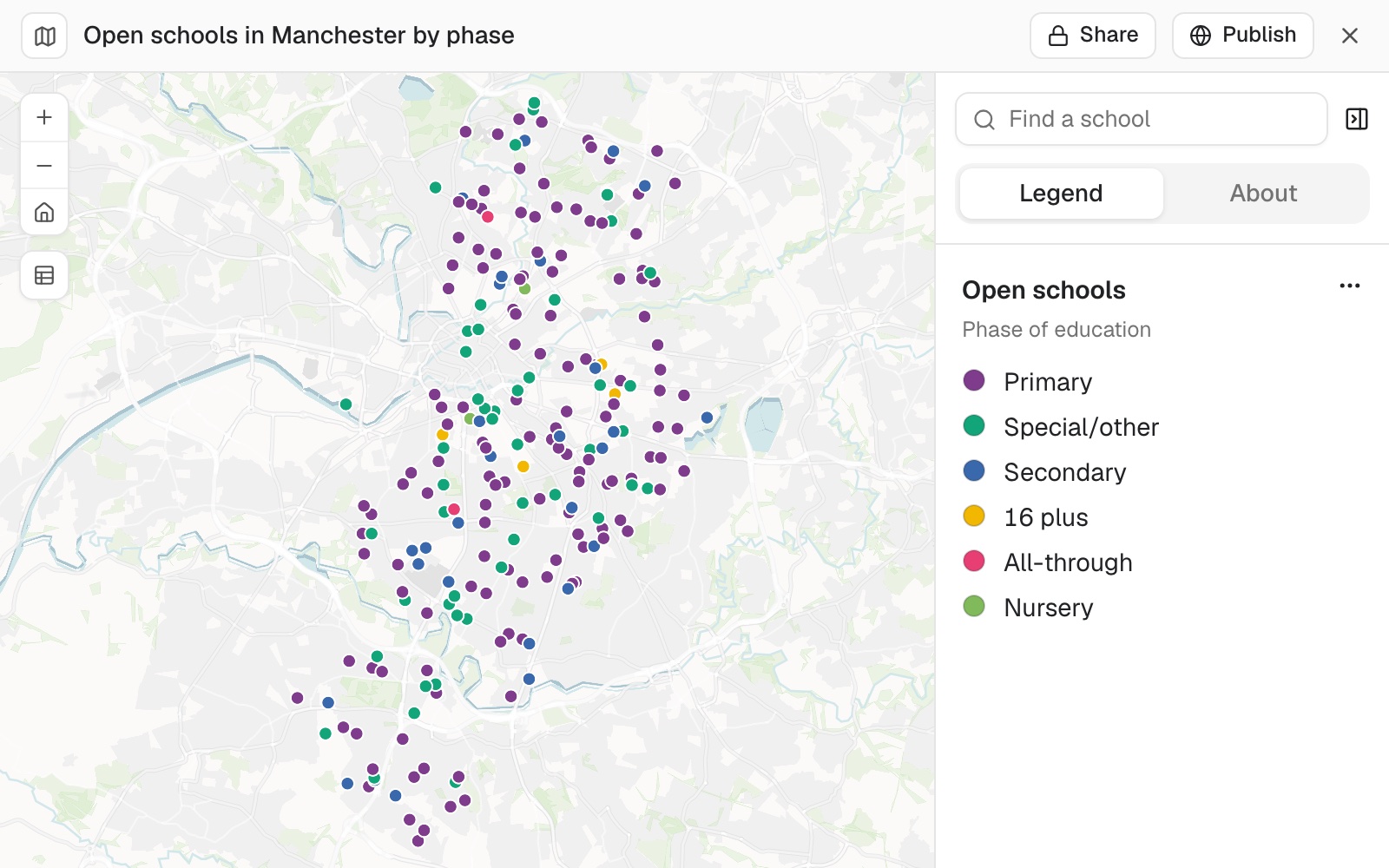 Example: the 222 open schools on Manchester's register, coloured by the tidied phase of education.
You hand it back as a file
The client's GIS team wants this back as a GeoPackage in British National Grid (EPSG:27700). Can you do that?
Download it yourself: open the dataset, select Download, then GeoPackage. Mapstack does not make the file in the conversation, and it says where to go. The GeoPackage is in latitude and longitude, not British National Grid; Mapstack does not reproject to another system. The original Easting and Northing columns are still in it, so the receiving team can reproject the layer in their own GIS or plot the points from those columns. See Download and export.
Make it your own
How many open schools and how many pupils are there in each phase? Give me a table.
Common questions
What if my coordinates aren't latitude and longitude?
Say what they are, as "eastings and northings" or by the system's name or EPSG code, and Mapstack converts them on the way in. Points in the sea or in the wrong country usually mean the coordinates were read in the wrong system: say which it is and ask Mapstack to place them again.
Can I see what was dropped, and why?
Yes. Ask "How many rows did you drop at each step, and why?" Rows with neither coordinates nor an address cannot be placed; add what is missing to the file and attach it again.
How do I check where things landed?
Look for points far from the rest, and read that row's address. A far point is either a fact about the data, like Manchester's schools in Wythenshawe, or a wrong coordinate to correct in the dataset (see Edit a dataset).
Can I hand it back in British National Grid, or as a shapefile?
No. Downloads are .csv, GeoPackage or GeoJSON, in latitude and longitude (WGS 84, EPSG:4326). Keep the original coordinate columns, and the receiving team can reproject or convert the file in their own GIS.