

Make a map figure to a standard for a report or committee pack
Turn a map into a print-ready figure at a set paper size, with a title block, scale, north arrow, key and credits.
Best for
Anyone who has to put a map into a document that follows a standard: a committee pack, a planning submission, a consultancy report, an evidence base. You end up with a one-page figure, designed for the paper size, that you download as a PDF or a picture and reissue when something changes.
The example in this guide continues Find what share of residents can walk to a bus stop: a map of active bus stops in each of Liverpool's 64 wards, made from the Department for Transport's NaPTAN stop list and the ONS May 2024 ward boundaries. It counts 1,906 stops, from 6 in the emptiest ward to 97 in the busiest.
What you need
- A map, or the datasets to make one, in the session.
- A Creator or Creator Max seat. Prints are made on paid seats.
- The standard you are working to: the paper size and orientation, and what must be on the page.
Before you start
- Name everything the page must carry. Title block, figure number, revision, date, scale bar and scale statement, north arrow, key, labels, sources and copyright. What you name is put on the page; what you leave out, Mapstack decides.
- One figure is one page. A large set of numbered labels can carry its list on a second page; there are no map books or series of sheets.
The prompt
Now a print for the committee pack: an A3 landscape GIS sheet of active bus stops by ward. Title block with figure number 1, revision 0 and today's date, scale bar and scale statement, north arrow, legend, ward labels, and a sources and copyright note.
What to expect
Mapstack designs the page to the paper
The map, the key and the title block are laid out for the paper size you named, and the scale is worked out for it: in the example, 1:70,000 at A3, with the note "Print at 100%". The key explains what the colours show, and a note says what the values mean: in the example, "Stops counted per ward."
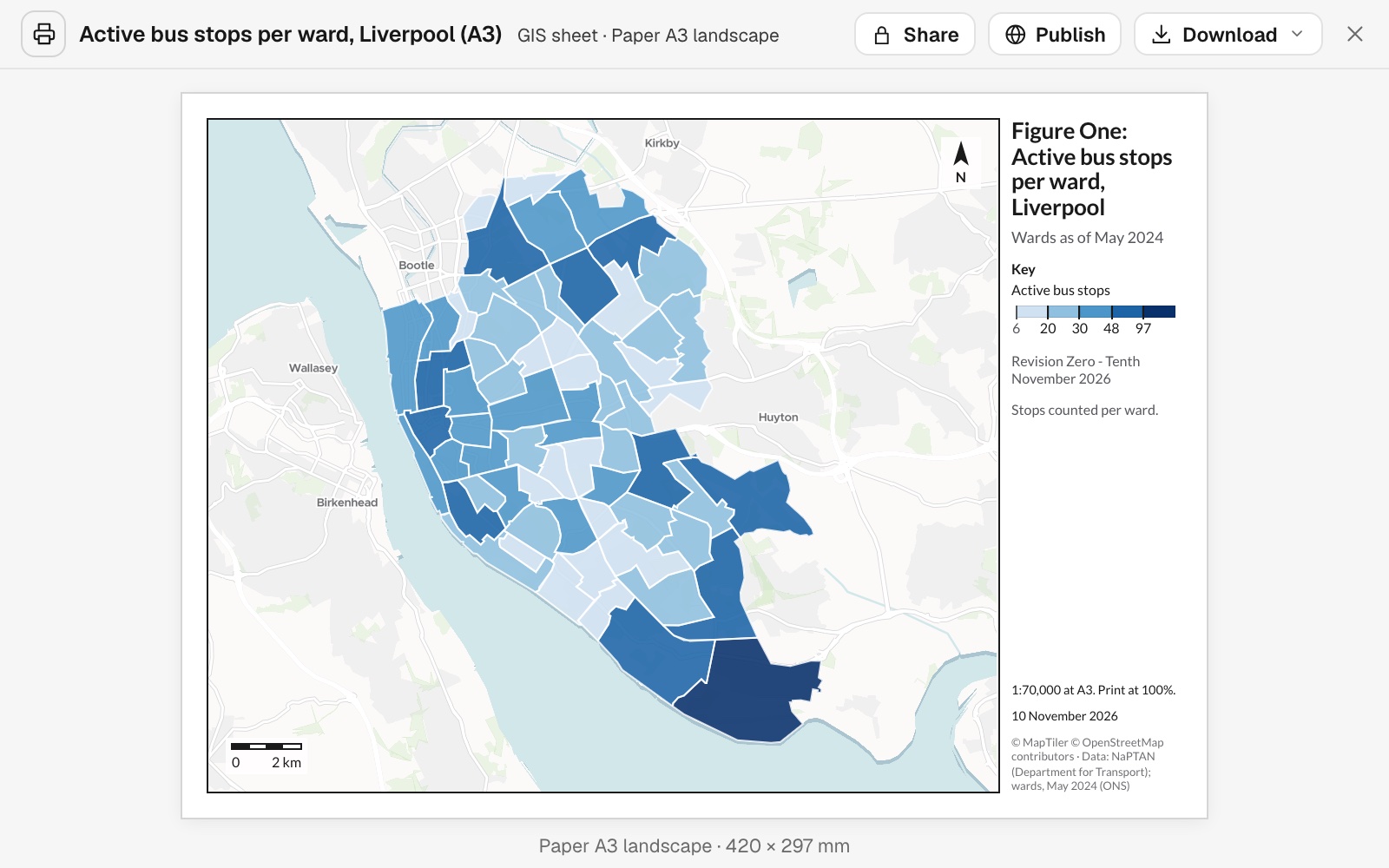 Example: the A3 landscape GIS sheet of active bus stops per ward, with its title block, key, north arrow, scale bar, scale statement and credits.
It tells you where it departed from the brief
If an item you asked for would harm the page, Mapstack says so and says what it did instead. In the example it left the 64 ward labels off because they would overlap in the smaller wards, and pointed to the map and the report, where every name can be read.
You check it against your standard
Read it as you would a colleague's draft, against the checklist you work to. Check the wording of the title block, the credits and the scale statement: in the example the revision and date were written out in words ("Revision Zero - Tenth November 2026") rather than in the house style "Rev 0".
You change it by asking, and reissue it
A print is changed by asking, never by editing the picture. Say what should change, and anything you do not mention stays as it was. When the data changes, ask for the next revision and the figure is made again from the current datasets.
Common questions
Can I have labels on the areas?
Yes: ask for labels on a few named areas, or for numbered labels with their list on a second page. Mapstack leaves labels off where they would collide, and says so.
Can I set the scale?
Yes. Ask for the scale or the paper size you need, and the page is designed again around it. Left open, Mapstack works the scale out for the paper: 1:70,000 at A3 in the example.
Can I set the exact wording of the title block?
Yes. Say the exact wording and Mapstack uses the words you give, with one exception: a figure number, revision or date is written out in words ("Revision Zero"), not digits. Check the title block, the credits and the scale statement against your standard, as you would a colleague's draft.
Can I make a series of sheets, or a map book?
No. One figure is one page. For several figures on one layout, see Make a set of figures in one style.
How do I reissue it when the data changes?
Ask for the next revision. The figure is made again from the current datasets, and anything you do not mention stays as it was.