

Your first map
How Mapstack turns your data and one sentence into a map, and the habits that get you a good result.
You give Mapstack some data and say what you want, and it gives you back a map you can explore, change and share. This page explains what happens in between, so you know what to expect and how to get the best out of it.
The example throughout is the site list of Pretzel Hatch, the kiosk chain these docs return to: 149 sites, each with its name (the London station it trades at), its postcode, its format (Kiosk, Counter or Unit) and its weekday covers. The stations and postcodes are real; the company and its figures are made up for the example.
Start with your file and one sentence
You can begin on mapstack.io before you have an account. Attach your spreadsheet, say what you want, and send it. Mapstack asks you to sign up at that point, then carries on with what you asked.
Map our sites and colour them by format
Say what the map is for and what matters. The more exactly you say it, the less Mapstack has to ask. See How to ask for things.
Your data becomes a dataset first
Mapstack does not draw your spreadsheet. It first turns it into a dataset: your rows, each with a place on the earth. Then it makes the map from that dataset.
The two are separate on purpose. The dataset is where your data lives: you open it to check a value, fix a row or download it. A map is one way of showing it, and you can make several from the same data. Change the dataset and the maps made from it change too.
Giving a place to each row is a judgement
How a row gets its place depends on what your file holds:
- Coordinates (latitude and longitude) are used as they are. There is nothing to decide.
- Addresses are looked up with a geocoding service, which finds the place whose name best matches. This is geocoding.
- Area names or codes (postcodes, districts, counties) are matched to their boundaries.
Coordinates are exact. The other two are a matter of reading: a geocoder reading "5 Bold Street, Liverpool" does what you would do, and like you it can be misled when the same street name exists in another town. A postcode on every row, as in the example, narrows each match a long way.
So every row also gets a Geocode Match Quality (premises, street or area), which says how precise the match was. It does not say whether it was right.
The map does more than you asked
You say what the map is for, and Mapstack designs the rest. Asked only to colour by format, it also adds a legend, a search box for site names, filters, and the full record for anything you select.
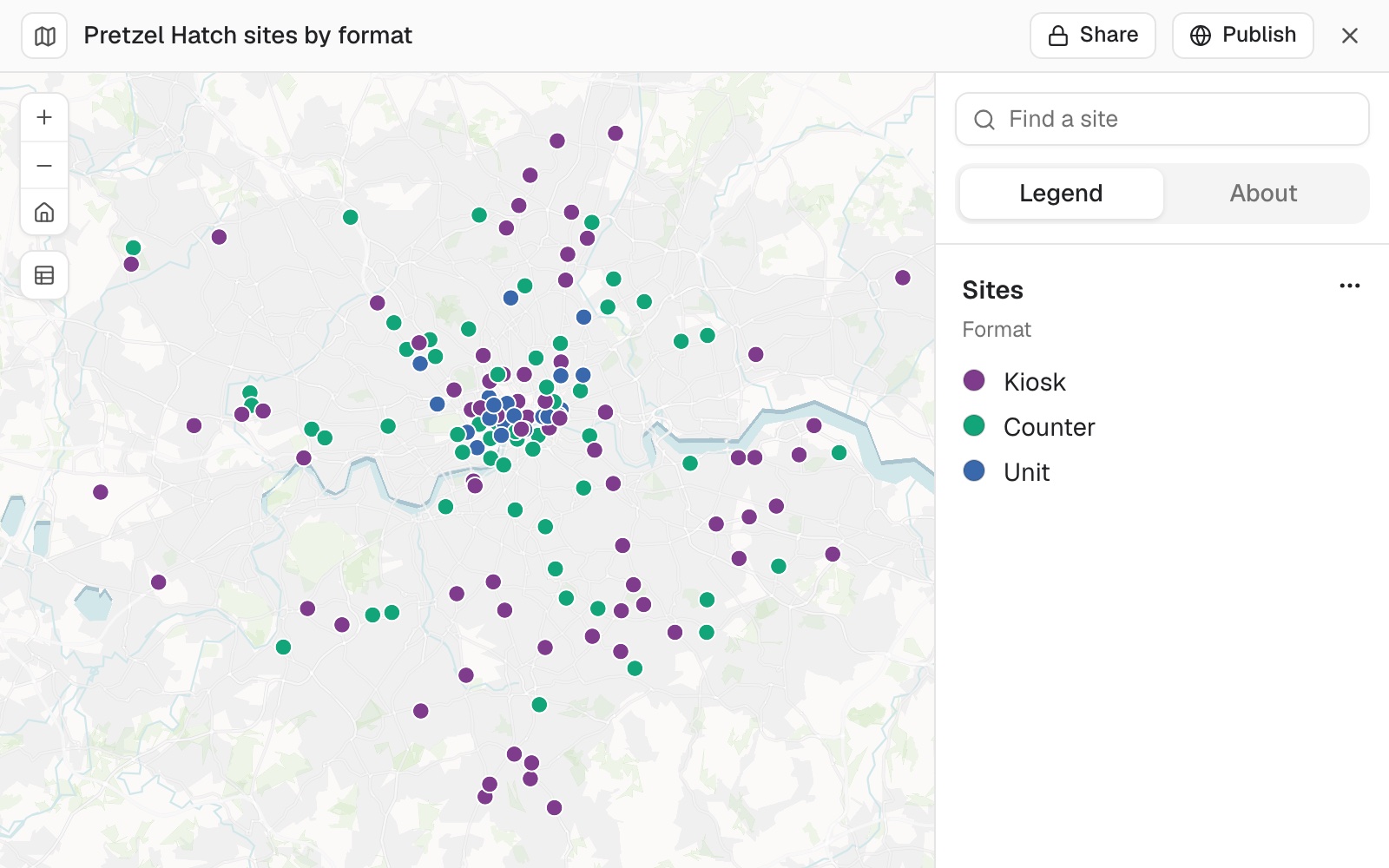 Example: the map Mapstack made from the one sentence above: 71 kiosks, 56 counters and 22 units.
Ask for the same thing twice and the two maps will not be identical. Each is a fresh piece of design.
Check it like a colleague's work
Before you use a map or send it on, check it as you would a colleague's first draft. Mapstack tells you what it did; look for yourself as well.
- Look for points far from the rest. In the picture above, the one at the bottom, Whyteleafe.
- Ask it to check against where they should be. Mapstack fetches the boundary and tests every point. In the example it finds one site outside Greater London, Whyteleafe, just over the line in Surrey, which is where that station really is: a point outside is a question to answer, and here the answer is that it is right.
Are any of our sites placed outside Greater London?
- Ask which were only placed roughly.
Which of our sites were only matched to an area, not to the premises or the street?
When something is wrong, the fix is usually in the data: add the town or postcode and attach the file again, or move the point yourself in the dataset. See Map a spreadsheet of addresses.
Change it by asking
Say what should change. Anything you do not mention stays as it was.
On the map, make the Units red so they stand out
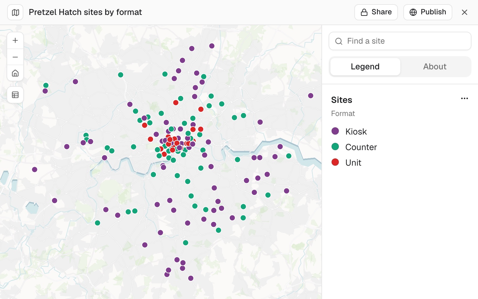 Example: the same map after that one request: the 22 units in red, the rest unchanged.
When Mapstack cannot do something, it says so and tells you what to do instead. Asked to move a point, it explains that you move points yourself in the dataset, and how.
Share it
A map starts private: only people with a seat in your workspace can open it. Share gives you a link for them. Publish makes it public, so anyone with the link can open it without signing in. See Make something public.
Find it again
There is nothing to save. The dataset and the map are in your Library, and the conversation is in the sidebar under Recents. Open either one later and carry on.
Work like this uses part of your allowance. See Your allowance.